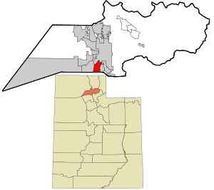
Country:
 USA
USARegion:
City:
Latitude and Longitude:
Time Zone:
Postal Code:
IP information under different IP Channel
ip-api
Country
Region
City
ASN
Time Zone
ISP
Blacklist
Proxy
Latitude
Longitude
Postal
Route
IPinfo
Country
Region
City
ASN
Time Zone
ISP
Blacklist
Proxy
Latitude
Longitude
Postal
Route
MaxMind
Country
Region
City
ASN
Time Zone
ISP
Blacklist
Proxy
Latitude
Longitude
Postal
Route
Luminati
Country
USRegion
pa
City
pittsburgh
ASN
Time Zone
America/New_York
ISP
DATABANK-DFW
Latitude
Longitude
Postal
db-ip
Country
Region
City
ASN
Time Zone
ISP
Blacklist
Proxy
Latitude
Longitude
Postal
Route
ipdata
Country
Region
City
ASN
Time Zone
ISP
Blacklist
Proxy
Latitude
Longitude
Postal
Route
Popular places and events near this IP address
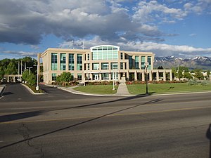
Clearfield, Utah
City in Utah, United States
Distance: Approx. 5635 meters
Latitude and longitude: 41.10638889,-112.02416667
Clearfield (Shoshone: Gu-ta-nu-a-de, “Place where the wind blows hard”) is a city in Davis County, Utah, United States. The population was 31,909 at the 2020 census. The city grew rapidly during the 1940s, with the formation of Hill Air Force Base, and in the 1950s with the nationwide increase in suburb and "bedroom" community populations and has been steadily growing since then.

Clinton, Utah
City in Utah, United States
Distance: Approx. 1500 meters
Latitude and longitude: 41.13944444,-112.05333333
Clinton is a city in Davis County, Utah, United States. It is part of the Ogden–Clearfield, Utah Metropolitan Statistical Area. The population was 23,386 at the 2020 United States census, up from 20,426 in 2010 census.

Sunset, Utah
City in Utah, United States
Distance: Approx. 2245 meters
Latitude and longitude: 41.14055556,-112.02972222
Sunset is a city in Davis County, Utah, United States. It is part of the Ogden–Clearfield, Utah Metropolitan Statistical Area. The population was 5,122 at the 2010 census.

West Point, Utah
City in Utah, United States
Distance: Approx. 4693 meters
Latitude and longitude: 41.12138889,-112.08833333
West Point is a city in Davis County, Utah, United States. It is part of the Ogden–Clearfield, Utah Metropolitan Statistical Area. The population was 9,511 at the 2010 census, up from 6,033 in 2000.
Riverdale, Utah
City in Utah, United States
Distance: Approx. 4864 meters
Latitude and longitude: 41.17861111,-112.00416667
Riverdale is a city in southern Weber County, Utah, United States. The population was 8,426 at the 2010 census. It is part of the Ogden–Clearfield, Utah Metropolitan Statistical Area.

Roy, Utah
City in Utah, United States
Distance: Approx. 1987 meters
Latitude and longitude: 41.17055556,-112.04861111
Roy is a city in Weber County, Utah, United States, on the west side of Interstate 15. The population in 2020 was 39,306, an increase of 6.6% from 36,884 at the 2010 census. Roy is part of the Ogden−Clearfield Metropolitan Statistical Area, and is considered a suburb of nearby Ogden, although some small businesses are present in Roy.

West Haven, Utah
City in Utah, United States
Distance: Approx. 5600 meters
Latitude and longitude: 41.20277778,-112.05861111
West Haven is a city in Weber County, Utah, United States. The population was 10,272 at the 2010 census. It was incorporated on July 1, 1991, combining the unincorporated communities of Kanesville and Wilson.
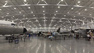
Hill Aerospace Museum
Military aviation museum in Roy, Utah
Distance: Approx. 2834 meters
Latitude and longitude: 41.16194444,-112.01944444
Hill Aerospace Museum is a military aviation museum located at Hill Air Force Base in Roy, Utah. It is dedicated to the history of the base and aviation in Utah.

Syracuse High School (Syracuse, Utah)
Public high school in Syracuse, Utah, United States
Distance: Approx. 5473 meters
Latitude and longitude: 41.10444444,-112.06277778
Syracuse High School (also called Syracuse High or SHS) is a public high school in Syracuse, Utah, United States. It is part of the Davis School District. Syracuse High School offers many Advanced Placement, concurrent enrollment and honors courses.
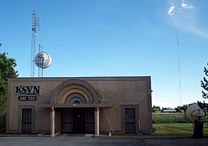
KSVN (AM)
Radio station in Utah, United States
Distance: Approx. 4704 meters
Latitude and longitude: 41.18805556,-112.08194444
KSVN (730 AM) is a radio station broadcasting a Regional Mexican format. Licensed to Ogden, Utah, United States, it serves the Ogden and Salt Lake City area. The station is currently owned by Azteca Broadcasting Corporation.

Roy station
Commuter rail station in Roy, Utah, US
Distance: Approx. 4138 meters
Latitude and longitude: 41.18888889,-112.03916667
Roy station is a FrontRunner commuter rail station in Roy, Utah, United States. It is operated by the Utah Transit Authority (UTA).
Davis–Weber Canal
Distance: Approx. 3623 meters
Latitude and longitude: 41.15916667,-112.00861111
The Davis–Weber Canal (also known as the Davis and Weber Counties Canal) is a canal in southern Weber and northern Davis counties in northern Utah, United States, that flows around the north and west sides of Hill Air Force Base (Hill AFB), supplying water from the Weber River to the area.
Weather in this IP's area
clear sky
27 Celsius
26 Celsius
25 Celsius
28 Celsius
1014 hPa
23 %
1014 hPa
873 hPa
10000 meters
3.09 m/s
300 degree
07:31:34
18:59:51