Country:
Region:
City:
Latitude and Longitude:
Time Zone:
Postal Code:
IP information under different IP Channel
ip-api
Country
Region
City
ASN
Time Zone
ISP
Blacklist
Proxy
Latitude
Longitude
Postal
Route
IPinfo
Country
Region
City
ASN
Time Zone
ISP
Blacklist
Proxy
Latitude
Longitude
Postal
Route
MaxMind
Country
Region
City
ASN
Time Zone
ISP
Blacklist
Proxy
Latitude
Longitude
Postal
Route
Luminati
Country
Region
pa
City
pittsburgh
ASN
Time Zone
America/New_York
ISP
DATABANK-DFW
Latitude
Longitude
Postal
db-ip
Country
Region
City
ASN
Time Zone
ISP
Blacklist
Proxy
Latitude
Longitude
Postal
Route
ipdata
Country
Region
City
ASN
Time Zone
ISP
Blacklist
Proxy
Latitude
Longitude
Postal
Route
Popular places and events near this IP address

Civic Arena (Pittsburgh)
Arena in Pittsburgh
Distance: Approx. 374 meters
Latitude and longitude: 40.44166667,-79.99
The Civic Arena, formerly the Civic Auditorium and later Mellon Arena, was an arena located in Downtown Pittsburgh, Pennsylvania. The Civic Arena primarily served as the home to the Pittsburgh Penguins, the city's National Hockey League (NHL) franchise, from 1967 to 2010. Constructed in 1961 for use by the Pittsburgh Civic Light Opera (CLO), it was the brainchild of department store owner Edgar J. Kaufmann.

UPMC Cooper Fieldhouse
Indoor arena in Pittsburgh
Distance: Approx. 432 meters
Latitude and longitude: 40.4374,-79.9879
UPMC Cooper Fieldhouse, originally known as A.J. Palumbo Center, is a 3,500-seat multi-purpose arena in the Uptown area of Pittsburgh, Pennsylvania. The arena originally opened in 1988 and is part of Duquesne University. It is home to both the Duquesne Dukes basketball and volleyball programs.
Crawford Square
Distance: Approx. 202 meters
Latitude and longitude: 40.4427,-79.9854
Crawford Square is a New Urbanist apartment and townhome community located in Pittsburgh, Pennsylvania.

PPG Paints Arena
Multi-purpose indoor arena in Pittsburgh
Distance: Approx. 335 meters
Latitude and longitude: 40.43944444,-79.98916667
PPG Paints Arena is a multi-purpose indoor arena in Pittsburgh that serves as the home of the Pittsburgh Penguins of the National Hockey League (NHL). It previously was the home of the Pittsburgh Power of the Arena Football League (AFL) from 2011 to 2014. Construction was completed on August 1, 2010, and the arena opened in time for the 2010–11 NHL season.

City View (Pittsburgh)
Apartment block in Pittsburgh
Distance: Approx. 70 meters
Latitude and longitude: 40.44055556,-79.98638889
City View is a 300 ft (91m) residential highrise in Pittsburgh, Pennsylvania. It was completed in 1964 and has 26 floors. It is tied with the Commonwealth Building and The Carlyle for the 26th tallest building in Pittsburgh.
Saint Joseph's House of Hospitality (Pittsburgh)
Hostel for homeless men in Pennsylvania, US
Distance: Approx. 451 meters
Latitude and longitude: 40.44492,-79.98639
St. Joseph's House of Hospitality is a home for homeless men in Pittsburgh, Pennsylvania. It was founded in 1937 by the Catholic Radical Alliance on the principles of the Catholic Worker Movement, and is named for St.

Kaufmann's Department Store Warehouse
United States historic place
Distance: Approx. 327 meters
Latitude and longitude: 40.43805556,-79.98666667
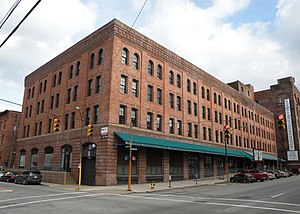
The Kaufmann's Department Store Warehouse (also known as the Forbes Stevenson Building, or Forbes Med-Tech Center) located in the Bluff neighborhood of Pittsburgh, Pennsylvania, is a building from 1901. It was listed on the National Register of Historic Places in 1997.

Reymer Brothers Candy Factory
United States historic place
Distance: Approx. 348 meters
Latitude and longitude: 40.43777778,-79.98555556
The Reymer Brothers Candy Factory (also known as the Forbes Pride Building, or Forbes Med-Tech Center) is located in the Bluff neighborhood of Pittsburgh, Pennsylvania. Built in 1906, it was designed in the Richardsonian Romanesque style. The building was listed on the National Register of Historic Places in 1997.

Energy Innovation Center
Building
Distance: Approx. 449 meters
Latitude and longitude: 40.44424444,-79.98866667
The Energy Innovation Center is a multi-disciplinary institution in Pittsburgh, Pennsylvania, United States, that integrates workforce development programs, green technology research laboratories, a business incubator and collaborative university-industry projects. It is housed in the former Clifford B. Connelley Trade School, which was renovated both to accommodate diverse uses and to serve as a case study for green adaptive reuse. In 2014 the renovated building received the Engineers' Society of Western Pennsylvania Project of the Year Award for Sustainability.

St. Benedict the Moor Catholic Church (Pittsburgh)
Historic site in Pennsylvania, USA
Distance: Approx. 59 meters
Latitude and longitude: 40.44141111,-79.98590278
St. Benedict the Moor Catholic Church is a Black Catholic parish in the Hill District neighborhood of Pittsburgh, Pennsylvania. It was built in 1894 and became a personal parish for African-Americans in June 2020.

Church of the Epiphany (Pittsburgh)
Roman Catholic church in Pittsburgh, Pennsylvania
Distance: Approx. 432 meters
Latitude and longitude: 40.44003333,-79.99066944
Church of the Epiphany located at Washington Place and Centre Avenue in the Hill District neighborhood of Pittsburgh, Pennsylvania, was built in 1902. The church was added to the List of Pittsburgh History and Landmarks Foundation Historic Landmarks in 1998. It is situated next to PPG Paints Arena.

Irene Kaufmann Settlement
Distance: Approx. 405 meters
Latitude and longitude: 40.4429,-79.9817
Irene Kaufmann Settlement (IKS), known as the Columbian School and Settlement from 1895 to 1910, was a settlement house located in Pittsburgh, Pennsylvania, US, at 1835 Center Avenue. It was the idea of Pauline Hanauer Rosenberg and established by the Columbian Council (now known as the National Council of Jewish Women - Pittsburgh Section) for moral, educational, and religious training. "The special purposes of the Settlement is the advancement of the civic, intellectual and social welfare of the surrounding community.
Weather in this IP's area
clear sky
11 Celsius
10 Celsius
9 Celsius
12 Celsius
1018 hPa
84 %
1018 hPa
984 hPa
10000 meters
0.45 m/s
0.45 m/s
344 degree
7 %
06:53:38
19:42:20