208.46.169.42 - IP Lookup: Free IP Address Lookup, Postal Code Lookup, IP Location Lookup, IP ASN, Public IP
Country:
Region:
City:
Location:
Time Zone:
Postal Code:
IP information under different IP Channel
ip-api
Country
Region
City
ASN
Time Zone
ISP
Blacklist
Proxy
Latitude
Longitude
Postal
Route
Luminati
Country
Region
nv
City
lasvegas
ASN
Time Zone
America/Los_Angeles
ISP
LA-ENC-ASN1
Latitude
Longitude
Postal
IPinfo
Country
Region
City
ASN
Time Zone
ISP
Blacklist
Proxy
Latitude
Longitude
Postal
Route
IP2Location
208.46.169.42Country
Region
california
City
encino
Time Zone
America/Los_Angeles
ISP
Language
User-Agent
Latitude
Longitude
Postal
db-ip
Country
Region
City
ASN
Time Zone
ISP
Blacklist
Proxy
Latitude
Longitude
Postal
Route
ipdata
Country
Region
City
ASN
Time Zone
ISP
Blacklist
Proxy
Latitude
Longitude
Postal
Route
Popular places and events near this IP address

Coast to Coast AM
American radio talk show
Distance: Approx. 1410 meters
Latitude and longitude: 34.15333333,-118.46555556
Coast to Coast AM is an American late-night radio talk show that deals with a variety of topics. Most frequently the topics relate to either the paranormal or conspiracy theories. It was hosted by creator Art Bell from its inception in 1988 until 2003, and is currently hosted by George Noory.

Sepulveda Dam
Dam in San Fernando Valley, California
Distance: Approx. 894 meters
Latitude and longitude: 34.1671,-118.4732
The Sepulveda Dam is a dry dam constructed by the U.S. Army Corps of Engineers to withhold winter flood waters along the Los Angeles River. Completed in 1941, at a cost of $6,650,561 (equivalent to $137,766,000 in 2023), it is located south of center in the San Fernando Valley, approximately eight miles (13 km) east of the river's source in the western end of the Valley, in Los Angeles, California. Sepulveda Dam, along with Hansen Dam located in the north San Fernando Valley, was constructed in response to the historic 1938 floods which killed 144 people.

Sherman Oaks Galleria
Shopping mall in California, U.S.
Distance: Approx. 1336 meters
Latitude and longitude: 34.15416667,-118.46666667
Sherman Oaks Galleria is an open-air shopping mall and business center located in the Sherman Oaks neighborhood of Los Angeles, California, United States, at the corner of Ventura and Sepulveda Boulevards in the San Fernando Valley. The teenage mall culture which formed around it and nearby malls formed the basis of the 1982 satirical song "Valley Girl" by Frank Zappa and daughter Moon Zappa, which mentions the Galleria by name, though it misattributes its location as Encino, which it abuts. The mall has been a shooting location for many films, most notably the seminal 1982 film Fast Times at Ridgemont High as well as the 1983 film Valley Girl, both of which focused on the early 1980s San Fernando Valley youth culture.

Sepulveda station
Los Angeles Metro Busway station
Distance: Approx. 1737 meters
Latitude and longitude: 34.1809,-118.4688
Sepulveda station is a station on the G Line of the Los Angeles Metro Busway system. It is named after nearby Sepulveda Boulevard, which travels north-south and crosses the east-west busway route. Unique among G Line stations, Sepulveda's platforms are not located at the cross street, but rather about a block west of it.
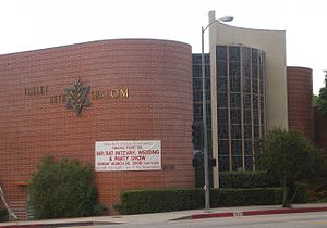
Valley Beth Shalom
Conservative synagogue in Los Angeles, California, United States
Distance: Approx. 1674 meters
Latitude and longitude: 34.15560833,-118.47685556
Valley Beth Shalom (informally called VBS) is a Conservative synagogue at 15739 Ventura Boulevard in Encino, Los Angeles, California, in the United States. With approximately 1,500 member families, it is one of the largest synagogues in Los Angeles and one of the largest Conservative synagogues in the United States.

St. Cyril of Jerusalem Church and School
Catholic Church in California, United States
Distance: Approx. 1517 meters
Latitude and longitude: 34.15442,-118.47247
St. Cyril of Jerusalem Church and School is a Catholic church and elementary school located in Encino, Los Angeles. Founded in 1949, St.
Proto-Cathedral of St. Mary
Ruthenian Greek Catholic church in the US
Distance: Approx. 326 meters
Latitude and longitude: 34.16748056,-118.466575
The Proto-Cathedral of St. Mary or Proto-Cathedral of St. Mary Byzantine Catholic Church is a parish church and proto-cathedral of the Byzantine Catholic Eparchy of Phoenix, serving the Ruthenian Eastern Catholic population of Los Angeles, California, United States.

Leo Magnus Cricket Complex
Cricket ground
Distance: Approx. 2054 meters
Latitude and longitude: 34.18142778,-118.47565556
The Leo Magnus Cricket Complex (LMCC) or Sepulveda Basin Cricket Fields, aka Woodley Park, is a group of four cricket grounds located in the Van Nuys neighborhood of Los Angeles, California, United States. The facility is also called Woodley Cricket Field(s) or Woodley Cricket Complex due to its location in Woodley Park.

Woodley Park (Los Angeles)
Distance: Approx. 2062 meters
Latitude and longitude: 34.1795,-118.4788
Woodley Park is a recreation area managed by the City of Los Angeles and located along Woodley Avenue between Victory and Burbank Boulevards in the Lake Balboa neighborhood of Los Angeles, California. The area is located within the large Sepulveda Basin Recreation Area in the central San Fernando Valley. The Tillman Water Reclamation Plant is adjacent to the park and surrounded by The Japanese Garden, a large Japanese garden open to the public.

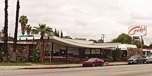
Corky's
Restaurant in California, United States
Distance: Approx. 1400 meters
Latitude and longitude: 34.16244,-118.448989
Corky's was a restaurant in Los Angeles, California's Sherman Oaks neighborhood. It was designed by Armet & Davis and built in 1958. It has a sweeping roofline characteristic of Googie architecture.

1977 Encino helicopter crash
Crash killing Francis Gary Powers
Distance: Approx. 1821 meters
Latitude and longitude: 34.16694444,-118.48333333
On August 1, 1977, a Bell 206 news helicopter piloted by American pilot Francis Gary Powers ran out of fuel and crashed into a field near Encino, Los Angeles, California, killing Powers and the aircraft's only passenger, cameraman George Spears.
Anajak Thai
Thai restaurant in Los Angeles, California, U.S.
Distance: Approx. 1859 meters
Latitude and longitude: 34.15152778,-118.45333333
Anajak Thai is a Thai restaurant in Sherman Oaks, California. The business earned Justin Pichetrungsi a James Beard Foundation Award in the Best Chef: California category.
Weather in this IP's area
clear sky
16 Celsius
15 Celsius
14 Celsius
18 Celsius
1017 hPa
53 %
1017 hPa
993 hPa
10000 meters
3.6 m/s
140 degree

