208.21.170.209 - IP Lookup: Free IP Address Lookup, Postal Code Lookup, IP Location Lookup, IP ASN, Public IP
Country:
Region:
City:
Location:
Time Zone:
Postal Code:
ISP:
ASN:
language:
User-Agent:
Proxy IP:
Blacklist:
IP information under different IP Channel
ip-api
Country
Region
City
ASN
Time Zone
ISP
Blacklist
Proxy
Latitude
Longitude
Postal
Route
db-ip
Country
Region
City
ASN
Time Zone
ISP
Blacklist
Proxy
Latitude
Longitude
Postal
Route
IPinfo
Country
Region
City
ASN
Time Zone
ISP
Blacklist
Proxy
Latitude
Longitude
Postal
Route
IP2Location
208.21.170.209Country
Region
california
City
agoura hills
Time Zone
America/Los_Angeles
ISP
Language
User-Agent
Latitude
Longitude
Postal
ipdata
Country
Region
City
ASN
Time Zone
ISP
Blacklist
Proxy
Latitude
Longitude
Postal
Route
Popular places and events near this IP address

Agoura Hills, California
City in California, United States
Distance: Approx. 2225 meters
Latitude and longitude: 34.15333333,-118.76166667
Agoura Hills ( ) is a city situated in the Santa Monica Mountains region of Los Angeles County, California, United States. With a population of 20,330 as of the 2010 census, which decreased to 20,299 in 2020. Agoura Hills lies in the eastern Conejo Valley, nestled between the Simi Hills and the Santa Monica Mountains.
Peter Strauss Ranch
Regional park in Los Angeles County, CA operated by the National Park Service
Distance: Approx. 2617 meters
Latitude and longitude: 34.11333333,-118.78
The Peter Strauss Ranch is a regional park unit of the Santa Monica Mountains National Recreation Area - and operated by the National Park Service as Peter Strauss Ranch Park. It is located in the central Santa Monica Mountains — on Mulholland Highway near Agoura Hills, Southern California, in the Western United States. The ranch is named after the actor Peter Strauss, who was the last private owner-resident of the property.
Church of the Holy Family (Agoura Hills, California)
Catholic church in Agoura Hills, California, United States
Distance: Approx. 2886 meters
Latitude and longitude: 34.112062,-118.785292
Holy Family is a private, independent traditionalist Catholic chapel located behind a guarded gate at 30188 W. Mulholland Highway, Agoura Hills, California, United States. It is not affiliated with the Archdiocese of Los Angeles. Its 70 or so members are traditional Catholics, including some that hold a sedevacantism position.

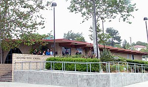
Agoura High School
Public school in Agoura Hills, California, United States
Distance: Approx. 2842 meters
Latitude and longitude: 34.15027778,-118.74861111
Agoura High School is a public high school in Agoura Hills, California, United States. It is the largest high school in the Las Virgenes Unified School District.
Indian Hills High School (Agoura Hills, California)
School in Agoura Hills, CA
Distance: Approx. 2824 meters
Latitude and longitude: 34.15034722,-118.74890278
Indian Hills High School is an alternative/continuation education high school in Agoura Hills, California, United States, serving students in grades 10–12. It is in the Las Virgenes Unified School District. Originally the school was located in an old church building, in then Agoura, today Agoura Hills California.

Agoura, California
Unincorporated community in California, United States
Distance: Approx. 3539 meters
Latitude and longitude: 34.14305556,-118.73694444
Agoura () is an unincorporated community in Los Angeles County, California, United States. Located southeast of the city of Agoura Hills and adjacent to the city of Calabasas, Agoura was the historical name of the area before much of the area was developed and before the incorporation of the city of Agoura Hills. There are a few nearby pockets of unincorporated areas that contain a handful of houses.

Rancho Las Vírgenes
Historic land grant in Southern California, United States
Distance: Approx. 2795 meters
Latitude and longitude: 34.15,-118.8
Rancho Las Vírgenes was a 17,760-acre (71.9 km2) land grant in the Santa Monica Mountains and Simi Hills, in present day western Los Angeles County, California. The lands of the Rancho Las Vírgenes included present day Agoura Hills, Oak Park, and Westlake Village and part of the Santa Monica Mountains. It was given in 1802 by Spanish Governor José Joaquín de Arrillaga to Miguel Ortega, but was abandoned after his death in 1809.

The Rock Store
Restaurant in California, United States
Distance: Approx. 3240 meters
Latitude and longitude: 34.109585,-118.788173
The Rock Store is a restaurant in Cornell, on Mulholland Highway in the Santa Monica Mountains, Los Angeles, California. It is popular with motorcyclists and celebrities.
Cornell, Los Angeles County, California
Unincorporated community in California, United States
Distance: Approx. 2463 meters
Latitude and longitude: 34.11444444,-118.77777778
Cornell is an unincorporated community in the Santa Monica Mountains, within western Los Angeles County, California. It is located 5 miles (8.0 km) west of Agoura Hills and around 2.5 miles (4.0 km) north of Malibu. Cornell's heyday was the 1910s to the 1950s, and the settlement is now essentially a ghost town but a handful of buildings and one functioning restaurant persisted circa 2007.

Seminole Hot Springs, California
Unincorporated community in California, United States
Distance: Approx. 3569 meters
Latitude and longitude: 34.10722222,-118.79055556
Seminole Hot Springs is an unincorporated community in Los Angeles County, California, United States. Seminole Hot Springs is located in the Santa Monica Mountains near Cornell, 3.6 miles (5.8 km) south-southeast of Agoura Hills at an elevation of 932 feet (284 m).
Paramount Ranch Racetrack
Distance: Approx. 2524 meters
Latitude and longitude: 34.121,-118.7544
Paramount Ranch Racetrack (sometimes called Paramount Ranch Raceway) was a motorsports racetrack located at Paramount Ranch in the Santa Monica Mountains in Agoura Hills, California. A total of seven events were held at Paramount Ranch from 1956-1957. After a series of fatalities in short proximity to each other, the track gained a reputation for being a dangerous circuit.
Valley Oaks Memorial Park
Cemetery, mortuary and crematory in Westlake Village, California
Distance: Approx. 2860 meters
Latitude and longitude: 34.1514,-118.7997
Valley Oaks Memorial Park is a cemetery, mortuary and crematory located at 5600 Lindero Canyon Road, in Westlake Village, California, United States. Viguen, the sultan of Iranian jazz music and an old Iranian actor who has been in exile for many years, is buried in this cemetery.
Weather in this IP's area
clear sky
19 Celsius
18 Celsius
18 Celsius
20 Celsius
1026 hPa
8 %
1026 hPa
993 hPa
10000 meters
3.58 m/s
6.71 m/s
32 degree