Country:
 USA
USARegion:
City:
Latitude and Longitude:
Time Zone:
Postal Code:
IP information under different IP Channel
ip-api
Country
Region
City
ASN
Time Zone
ISP
Blacklist
Proxy
Latitude
Longitude
Postal
Route
IPinfo
Country
Region
City
ASN
Time Zone
ISP
Blacklist
Proxy
Latitude
Longitude
Postal
Route
MaxMind
Country
Region
City
ASN
Time Zone
ISP
Blacklist
Proxy
Latitude
Longitude
Postal
Route
Luminati
Country
USASN
Time Zone
America/Chicago
ISP
SBT-NET
Latitude
Longitude
Postal
db-ip
Country
Region
City
ASN
Time Zone
ISP
Blacklist
Proxy
Latitude
Longitude
Postal
Route
ipdata
Country
Region
City
ASN
Time Zone
ISP
Blacklist
Proxy
Latitude
Longitude
Postal
Route
Popular places and events near this IP address
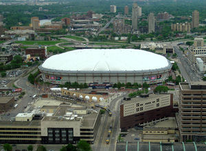
Hubert H. Humphrey Metrodome
Former stadium in Minneapolis, Minnesota
Distance: Approx. 391 meters
Latitude and longitude: 44.97388889,-93.25805556
The Hubert H. Humphrey Metrodome (commonly called the Metrodome) was a domed sports stadium located in downtown Minneapolis, Minnesota. It opened in 1982 as a replacement for Metropolitan Stadium, the former home of the National Football League's (NFL) Minnesota Vikings and Major League Baseball's (MLB) Minnesota Twins, and Memorial Stadium, the former home of the Minnesota Golden Gophers football team. The Metrodome was the home of the Vikings from 1982 to 2013, the Twins from 1982 to 2009, the National Basketball Association's (NBA) Minnesota Timberwolves in their 1989–90 inaugural season, the Golden Gophers football team from 1982 to 2008, and the occasional home of the Golden Gophers baseball team from 1985 to 2010 and their full-time home in 2012.
Mixed Blood Theatre Company
Distance: Approx. 421 meters
Latitude and longitude: 44.97093056,-93.249375
The Mixed Blood Theatre Company is a professional multiracial theatre company in Minneapolis, Minnesota. It was founded in 1976 by artistic director Jack Reuler, to explore race via the use of theater.

Cedar–Riverside station
Distance: Approx. 430 meters
Latitude and longitude: 44.9684,-93.2511
Cedar–Riverside station is a light rail station on the Blue Line in Minneapolis, Minnesota. The station is located between 15th and 16th Avenues South, near the interchange of Interstate 35W, Interstate 94, and Minnesota State Highway 55. It is a center-platform station and is one of a few stations where there are no designated bus routes to transfer to or from, though buses run along Cedar Avenue a few blocks away.
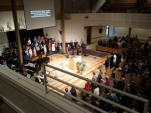
Bethlehem Baptist Church (Minneapolis)
Church in Minnesota, United States
Distance: Approx. 239 meters
Latitude and longitude: 44.96916667,-93.255
Bethlehem Baptist Church is a Baptist Evangelical megachurch based in Minneapolis, Minnesota. It is affiliated with Converge North Central and Converge.

Riverside Plaza
United States historic place
Distance: Approx. 480 meters
Latitude and longitude: 44.97,-93.24888889
Riverside Plaza is a modernist and brutalist apartment complex designed by Ralph Rapson that opened in Minneapolis, Minnesota in 1973. Situated on the edge of downtown Minneapolis in the Cedar-Riverside neighborhood, and next to both the University of Minnesota's West Bank and Augsburg University, the site contains the 39-story McKnight Building, the tallest structure outside of the city's central business district. Initially known as Cedar Square West, the complex was renamed when an investor group bought it out of receivership in 1988.

Downtown East, Minneapolis
Neighborhood in Hennepin, Minnesota, United States
Distance: Approx. 512 meters
Latitude and longitude: 44.9759,-93.2545
Downtown East is an official neighborhood in Minneapolis, Minnesota, United States. It is in Ward 3, currently represented by council member Michael Rainville. Its boundaries are the Mississippi River to the north, Interstate 35W to the east, 5th Street South to the south, and Portland Avenue to the west.
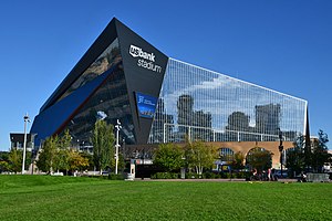
U.S. Bank Stadium
Multi-purpose stadium in Minneapolis, Minnesota, U.S.
Distance: Approx. 397 meters
Latitude and longitude: 44.974,-93.258
U.S. Bank Stadium is an enclosed stadium located in downtown Minneapolis, Minnesota. Built on the former site of the Hubert H. Humphrey Metrodome, the indoor stadium opened in 2016 and is the home of the Minnesota Vikings of the National Football League (NFL); it also hosts early season college baseball games of the University of Minnesota Golden Gophers. The Vikings played at the Metrodome from 1982 until its closure in 2013; during construction, the Vikings played two seasons (2014, 2015) at the open-air Huntington Bank Stadium on the campus of the University of Minnesota.
Minnesota Center for Book Arts
Largest and most comprehensive center and studio for the book arts in the United States
Distance: Approx. 460 meters
Latitude and longitude: 44.975414,-93.254176
Minnesota Center for Book Arts (MCBA) is the largest and most comprehensive independent nonprofit book arts center in the United States. Located in Minneapolis, Minnesota, MCBA is a nationally recognized leader in the celebration and preservation of traditional crafts, including hand papermaking, letterpress printing and hand bookbinding, as well as the use of these traditional techniques by contemporary artists in creating new artists' books and artwork.

Minnesota Technology Center
Buildings and structures in Minneapolis
Distance: Approx. 50 meters
Latitude and longitude: 44.97175,-93.25472222
The Minnesota Technology Center, formerly called the BTC/Bunker and also known as the 511 Building in reference to its address, is a colocation center located in downtown Minneapolis, Minnesota, near U.S. Bank Stadium and the West Bank campus of the University of Minnesota. The 511 Building has been referred to as "the most wired building in Minnesota" and is a major source of fiber optic data transmission and reception. It is operated by Timeshare Systems Inc.
Day Block Building
Distance: Approx. 436 meters
Latitude and longitude: 44.97505556,-93.25311111
The Day Block Building is a historic building located in the Mill City District of Downtown Minneapolis, Minnesota at 1103 Washington Ave S. The property was built in 1883 by Leonard Day, a local businessman of the lumber and flour milling trade, who settled in Minneapolis in 1851. Between 1880 and 1930, Minneapolis led the world's flour production, which resulted in the milling district being nicknamed "Mill City", a name still used today. It is unknown what the purpose the building served before it became occupied by Peter O Melby, also known as P.O. Melby, who used the basement and ground floor for his furniture-making business, as well as his undertaking services.

Philly Special
Notable American football play in Super Bowl LII
Distance: Approx. 304 meters
Latitude and longitude: 44.97334,-93.25726
The Philly Special, also known as Philly Philly, was an American football trick play between Philadelphia Eagles players Corey Clement, Trey Burton, and Nick Foles on fourth-down-and-goal toward the end of the second quarter of Super Bowl LII on February 4, 2018 at U.S. Bank Stadium in Minneapolis. On the play, quarterback Nick Foles moved up to behind his offensive line and Jason Kelce snapped the ball directly to running back Corey Clement. Clement went on to pitch the ball to Trey Burton, who passed the ball to a wide open Foles to score a touchdown.

Augustana Lutheran Church (Minneapolis)
Church in Minneapolis, Minnesota
Distance: Approx. 268 meters
Latitude and longitude: 44.97027778,-93.25777778
Augustana Lutheran Church is a church in the Elliot Park neighborhood of Minneapolis, built in the Gothic Revival style. Architect William H. Dennis built the church in 1883. The church building, located 704 11th Ave.
Weather in this IP's area
few clouds
29 Celsius
30 Celsius
27 Celsius
30 Celsius
1015 hPa
53 %
1015 hPa
987 hPa
10000 meters
4.63 m/s
160 degree
20 %
06:53:34
19:21:59