208.117.222.2 - IP Lookup: Free IP Address Lookup, Postal Code Lookup, IP Location Lookup, IP ASN, Public IP
Country:
Region:
City:
Location:
Time Zone:
Postal Code:
ISP:
ASN:
language:
User-Agent:
Proxy IP:
Blacklist:
IP information under different IP Channel
ip-api
Country
Region
City
ASN
Time Zone
ISP
Blacklist
Proxy
Latitude
Longitude
Postal
Route
db-ip
Country
Region
City
ASN
Time Zone
ISP
Blacklist
Proxy
Latitude
Longitude
Postal
Route
IPinfo
Country
Region
City
ASN
Time Zone
ISP
Blacklist
Proxy
Latitude
Longitude
Postal
Route
IP2Location
208.117.222.2Country
Region
louisiana
City
slidell
Time Zone
America/Chicago
ISP
Language
User-Agent
Latitude
Longitude
Postal
ipdata
Country
Region
City
ASN
Time Zone
ISP
Blacklist
Proxy
Latitude
Longitude
Postal
Route
Popular places and events near this IP address
Eden Isle, Louisiana
Census-designated place in Louisiana, United States
Distance: Approx. 5970 meters
Latitude and longitude: 30.22416667,-89.80027778
Eden Isle is a census-designated place (CDP) in St. Tammany Parish, Louisiana, United States, on the northeast shore of Lake Pontchartrain. The population was 7,041 at the 2010 census, and 7,782 in 2020.

Slidell, Louisiana
City in Louisiana, United States
Distance: Approx. 551 meters
Latitude and longitude: 30.27916667,-89.77777778
Slidell is a city on the northeast shore of Lake Pontchartrain in St. Tammany Parish, Louisiana, United States. The population was 28,781 at the 2020 census, making it the sixteenth-most populous city in Louisiana.

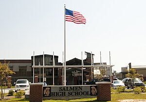
Salmen High School
Public secondary school in the United States
Distance: Approx. 3202 meters
Latitude and longitude: 30.24755,-89.79038
Salmen High School is a public high school in Slidell, Louisiana, United States, under the St. Tammany Parish School Board. The school serves southern Slidell and Eden Isle.

Slidell station
Train station in Slidell, Louisiana, US
Distance: Approx. 380 meters
Latitude and longitude: 30.27833333,-89.78277778
Slidell station is an Amtrak intercity train station in Slidell, Louisiana, served by the daily Crescent train. It was built in 1913 for the use of the New Orleans and Northeastern and the New Orleans Great Northern Railroads. Slidell was first established in 1881 as a construction camp for the NO&NE. The station is served by one daily Amtrak train.

St. Genevieve Church
Distance: Approx. 6174 meters
Latitude and longitude: 30.26888889,-89.845
St. Genevieve Church is a parish of the Roman Catholic Archdiocese of New Orleans located along the northeastern edge of Lake Pontchartrain in Slidell, Louisiana, United States. St.

Pope John Paul II Catholic High School (Louisiana)
Private school in Slidell, Louisiana, United States
Distance: Approx. 3648 meters
Latitude and longitude: 30.27972222,-89.74361111
Pope John Paul II Catholic High School is a private, Roman Catholic high school in Slidell, Louisiana, United States. It is located in the Roman Catholic Archdiocese of New Orleans.
North Shore Square
Shopping mall in Louisiana, United States
Distance: Approx. 5400 meters
Latitude and longitude: 30.30747,-89.82315
North Shore Square was a 621,192-square-foot (57,710.6 m2) shopping mall located in Slidell, Louisiana, United States. It was the largest mall on the north shore of Lake Pontchartrain, the 5th largest mall in the New Orleans area, and the 11th largest mall in Louisiana. The mall was home to three anchor stores: two Dillard's locations (One was originally a D. H. Holmes, and the second was originally a Maison Blanche, which opened in 1990.) At Home and Conn’s were with six other stores in the interior shortly before its closure.
Camp Salmen House
Historic house in Louisiana, United States
Distance: Approx. 4510 meters
Latitude and longitude: 30.29067,-89.82456
The Camp Salmen House is located on the shores of Bayou Liberty in St. Tammany Parish, west of Slidell, Louisiana, USA. It is a French Creole cottage, circa 1830. The house was built with a brick core, wood frame post rooms, a cabinet/loggia, and front gallery.
Francois Cousin House (Slidell, Louisiana)
Historic house in Louisiana, United States
Distance: Approx. 5207 meters
Latitude and longitude: 30.27118889,-89.83516111
The Francois Cousin House near Slidell is located in eastern St. Tammany Parish, Louisiana, west of the City of Slidell, Louisiana. The house is a French Creole Cottage, likely built between 1778 and 1790, by Jean Francois Cousin.
Bonfouca, Louisiana
Unincorporated community in Louisiana
Distance: Approx. 6117 meters
Latitude and longitude: 30.26916667,-89.84444444
Bonfouca (also Bonfonca, Boucffouca, Bouefuka, Boukfouca) is an unincorporated community in St. Tammany Parish, Louisiana, United States. It is on Louisiana Highway 433 adjacent to Liberty Bayou two miles west of Slidell.
Colt, Louisiana
Unincorporated community in Louisiana, United States
Distance: Approx. 5829 meters
Latitude and longitude: 30.30194444,-89.83333333
Colt (also Bonfouca Station) is an unincorporated community in St. Tammany Parish, Louisiana, United States.
Alton, Louisiana
Unincorporated community in Louisiana
Distance: Approx. 6464 meters
Latitude and longitude: 30.33083333,-89.76194444
Alton is an unincorporated community in St. Tammany Parish, Louisiana, United States. The community is located 3 mi (4.8 km) north of Slidell on U.S. Route 11, 1.25 miles (2.01 km) north of I-12.
Weather in this IP's area
overcast clouds
16 Celsius
15 Celsius
16 Celsius
17 Celsius
1028 hPa
71 %
1028 hPa
1027 hPa
10000 meters
3.6 m/s
140 degree
100 %


