Country:
 USA
USARegion:
City:
Latitude and Longitude:
Time Zone:
Postal Code:
IP information under different IP Channel
ip-api
Country
Region
City
ASN
Time Zone
ISP
Blacklist
Proxy
Latitude
Longitude
Postal
Route
IPinfo
Country
Region
City
ASN
Time Zone
ISP
Blacklist
Proxy
Latitude
Longitude
Postal
Route
MaxMind
Country
Region
City
ASN
Time Zone
ISP
Blacklist
Proxy
Latitude
Longitude
Postal
Route
Luminati
Country
USRegion
ca
City
oakland
ASN
Time Zone
America/Los_Angeles
ISP
LLNW
Latitude
Longitude
Postal
db-ip
Country
Region
City
ASN
Time Zone
ISP
Blacklist
Proxy
Latitude
Longitude
Postal
Route
ipdata
Country
Region
City
ASN
Time Zone
ISP
Blacklist
Proxy
Latitude
Longitude
Postal
Route
Popular places and events near this IP address

Paramount Theatre (Oakland, California)
Concert hall in Oakland, California
Distance: Approx. 407 meters
Latitude and longitude: 37.81,-122.26777778
The Paramount Theatre is a 3,040-seat Art Deco concert hall located at 2025 Broadway in Downtown Oakland. When it was built in 1931, it was the largest multi-purpose theater on the West Coast, seating 3,476. Today, the Paramount is the home of the Oakland East Bay Symphony and the Oakland Ballet.
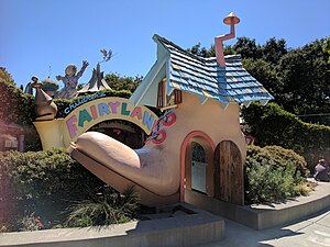
Children's Fairyland
Amusement park in Oakland, California
Distance: Approx. 430 meters
Latitude and longitude: 37.809,-122.2599
Children's Fairyland, U.S.A. is an amusement park, located in Oakland, California, on the shores of Lake Merritt. It was one of the earliest "themed" amusement parks in the United States. Fairyland includes 10 acres (4.0 ha) of play sets, small rides, and animals.

Cathedral of Christ the Light (Oakland, California)
Church in California, United States
Distance: Approx. 353 meters
Latitude and longitude: 37.8105,-122.2631
The Cathedral of Christ the Light, also called Oakland Cathedral, is the cathedral of the Roman Catholic Diocese of Oakland in Oakland, California. It is the seat of the Bishop of Oakland. Christ the Light was the first cathedral built entirely in the 21st century and replaced the Cathedral of Saint Francis de Sales, irreparably damaged in the Loma Prieta earthquake of 1989.

19th Street Oakland station
Metro station in Oakland, California, US
Distance: Approx. 405 meters
Latitude and longitude: 37.807869,-122.26898
19th Street Oakland station (signed as 19th St/Oakland) is an underground Bay Area Rapid Transit (BART) station located under Broadway between 17th Street and 20th Street in the Uptown District of Oakland, California. It is a timed transfer point between northbound trains to Richmond and to Antioch. The station has three underground levels, with tracks on the second and third levels.
Oaksterdam, Oakland
Cultural district in Oakland, California
Distance: Approx. 421 meters
Latitude and longitude: 37.80721,-122.26917
Oaksterdam is a cultural district on the north end of Downtown Oakland, California, where medical cannabis is available for purchase in cafés, clubs, and patient dispensaries. Oaksterdam is located between downtown proper, the Lakeside, and the financial district. It is roughly bordered by 14th Street on the southwest, Harrison Street on the southeast, 19th Street on the northeast, and Telegraph Avenue on the northwest.

Ordway Building
Skyscraper in Oakland, California
Distance: Approx. 269 meters
Latitude and longitude: 37.8099,-122.264
The Ordway Building (also known as One Kaiser Plaza) is a skyscraper located in downtown Oakland, California. The building lies close to Oakland's Lake Merritt and the tower contains 28 stories of office space. There are eight corner offices per floor, since the skyscraper has a H-shaped floor plan.
Kaiser Center
Commercial offices in Oakland, California
Distance: Approx. 145 meters
Latitude and longitude: 37.8088,-122.2644
Kaiser Center, also called the Kaiser Building, is a 28-story office building located at 300 Lakeside Drive, adjacent to Lake Merritt, in downtown Oakland, California, designed by the architectural firm of Welton Becket & Associates of Los Angeles. The property is bounded by Lakeside Drive, which terminates and joins Harrison Street at the site, 20th-, 21st-, and Webster-streets. When completed in 1960, it was Oakland's tallest building, as well as the largest office tower west of the Rocky Mountains.

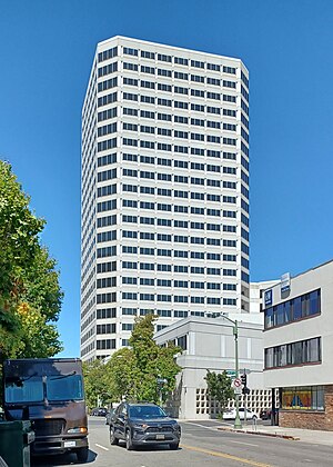
Lake Merritt Plaza
Office in Harrison Street, Oakland
Distance: Approx. 63 meters
Latitude and longitude: 37.80778333,-122.26502222
The Lake Merritt Plaza is a high-rise located in downtown Oakland, California, United States. It has 27 stories and stands at 371 ft (113 m) tall. The building, developed by Transpacific Development Co., is designed by architect Bill Valentine.
Kaiser Engineering Building
Office in Harrison Street, Oakland
Distance: Approx. 185 meters
Latitude and longitude: 37.80598611,-122.26525833
The Kaiser Engineering Building, also called the Raymond Kaiser Engineering Building, is a high-rise located in downtown Oakland, California. It has 25 stories and stands 336 ft (102 m) tall.

I. Magnin Building
Distance: Approx. 393 meters
Latitude and longitude: 37.809189,-122.268324
The I. Magnin Building is a former I. Magnin department store in Oakland, California located at 2001 Broadway. It was built in 1931 and designed by architecture firm Weeks and Day. It housed the upscale department store until it closed in 1995.

Glen Echo Creek
River in California, United States
Distance: Approx. 421 meters
Latitude and longitude: 37.81062,-122.26169
Glen Echo Creek (also known as Cemetery Creek) is a creek that runs from the Oakland Hills to Lake Merritt in Oakland, California. Although most of it is underground, the creek does surface in several locations. It has two branches, the Rockridge Branch and the Broadway Branch.

Harrison and Fifteenth Streets Historic District
Historic place in Oakland, California
Distance: Approx. 438 meters
Latitude and longitude: 37.803889,-122.266389
Harrison and Fifteenth Streets Historic District is a group of seven historical buildings in downtown Oakland, California, United States. The Harrison and Fifteenth Street Historic District buildings were built between 1914 and 1929. The buildings were listed on the National Register of Historic Places on November 7, 1996.
Weather in this IP's area
broken clouds
20 Celsius
19 Celsius
18 Celsius
22 Celsius
1012 hPa
65 %
1012 hPa
1011 hPa
10000 meters
3.13 m/s
6.71 m/s
299 degree
75 %
06:52:18
19:15:17