208.100.182.7 - IP Lookup: Free IP Address Lookup, Postal Code Lookup, IP Location Lookup, IP ASN, Public IP
Country:
 USA
USARegion:
City:
Location:
Time Zone:
Postal Code:
ISP:
ASN:
language:
User-Agent:
Proxy IP:
Blacklist:
IP information under different IP Channel
ip-api
Country
Region
City
ASN
Time Zone
ISP
Blacklist
Proxy
Latitude
Longitude
Postal
Route
db-ip
Country
Region
City
ASN
Time Zone
ISP
Blacklist
Proxy
Latitude
Longitude
Postal
Route
IPinfo
Country
Region
City
ASN
Time Zone
ISP
Blacklist
Proxy
Latitude
Longitude
Postal
Route
IP2Location
208.100.182.7Country
usRegion
oregon
City
bend
Time Zone
America/Los_Angeles
ISP
Language
User-Agent
Latitude
Longitude
Postal
ipdata
Country
Region
City
ASN
Time Zone
ISP
Blacklist
Proxy
Latitude
Longitude
Postal
Route
Popular places and events near this IP address

Mountain View High School (Bend, Oregon)
Public school in Bend, Oregon, United States
Distance: Approx. 3119 meters
Latitude and longitude: 44.077,-121.265
Mountain View High School (MVHS) is a public high school in the northwest United States, located in Bend, Oregon.

KRCO-FM
Radio station in Prineville–Bend, Oregon
Distance: Approx. 3909 meters
Latitude and longitude: 44.07777778,-121.33027778
KRCO-FM (95.7 MHz) is an American commercial radio station in Prineville, Oregon, broadcasting to the Bend, Oregon, area.
KMGX
Radio station in Bend, Oregon
Distance: Approx. 3909 meters
Latitude and longitude: 44.07777778,-121.33027778
KMGX (100.7 FM) is a radio station broadcasting a classic rock format. Licensed to Bend, Oregon, United States, the station serves the Bend area. The station is currently owned by Gcc Bend, LLC. On January 30, 2023 at 6 am, KMGX changed its format from adult contemporary to classic rock, branded as "The X 100.7".
KBND
Radio station in Bend, Oregon
Distance: Approx. 3830 meters
Latitude and longitude: 44.10694444,-121.24416667
KBND (1110 AM) is a radio station broadcasting a News Talk Information format. Licensed to Bend, Oregon, United States, the station serves the Bend area. The station is currently owned by Combined Communications and features programing from Fox News Radio, Compass Media Networks, Premiere Networks, Salem Radio Network, and Westwood One.

Trinity Lutheran School (Bend, Oregon)
Private school in Bend, Deschutes County, Oregon, United States
Distance: Approx. 2456 meters
Latitude and longitude: 44.08493,-121.265953
Trinity Lutheran School (TLS) is a private Lutheran school in Bend, Oregon, United States. It is owned and operated by Trinity Lutheran Church of the Lutheran Church – Missouri Synod. TLS serves approximately 645 students from pre-kindergarten through high school.
KBNW
Radio station in Bend, Oregon
Distance: Approx. 2148 meters
Latitude and longitude: 44.07972222,-121.28277778
KBNW (1340 AM) signed on the air August 29, 2008, broadcasting a News Talk Information format. Licensed to Bend, Oregon, United States, the station is owned by Summit Broadcasting Group, LLC (operated under a local marketing agreement by Horizon Broadcasting Group, LLC) and features programming from ABC News Radio, Compass Media Networks, Premiere Networks, and Westwood One, and is known as "News Radio KBNW".

Charles Boyd Homestead Group
United States historic place
Distance: Approx. 1884 meters
Latitude and longitude: 44.08396,-121.30324
The Charles Boyd Homestead is a group of three buildings that make up a pioneer ranch complex. It is located in Deschutes County north of Bend, Oregon, United States. The ranch buildings were constructed by Charles Boyd between 1905 and 1909.

St. Charles Medical Center – Bend
Hospital in Bend, Oregon, US
Distance: Approx. 3855 meters
Latitude and longitude: 44.0672,-121.269
St. Charles Medical Center – Bend is a hospital in Bend, Oregon, United States. It is the largest hospital in Central Oregon, and a level 2 trauma center.

Rock O' the Range Bridge
Bridge
Distance: Approx. 2704 meters
Latitude and longitude: 44.122345,-121.286861
The Rock O' the Range Bridge, also called the Swalley Canal Bridge, is a bridge located north of Bend, Oregon, U.S., on a street adjacent to U.S. Route 97. It is the only covered span in the state of Oregon on the east side of the Cascade Range. It is also one of very few privately owned covered bridges in Oregon.

Swalley Irrigation District
Irrigation district near Bend, Oregon, US
Distance: Approx. 1632 meters
Latitude and longitude: 44.11277778,-121.28833333
The Swalley Irrigation District supplies water to irrigators through a network of pipes and canals fed by the Deschutes River near Bend in the U.S. state of Oregon. The network, begun in 1899, is a closed system with an intake behind North Canal Dam in Bend and a main canal, the Swalley Canal, that runs north from the city for about 13 miles (21 km). The only covered bridge east of the Cascade Range in Oregon crosses the Swalley Canal.
Bend Gate (Kelly)
1998 sculpture by Lee Kelly in Bend, Oregon, U.S.
Distance: Approx. 3547 meters
Latitude and longitude: 44.068778,-121.307522
Bend Gate is an outdoor 1998 Cor-ten steel sculpture by Lee Kelly, installed in Bend, Oregon, United States. The work was acquired by the nonprofit organization Art in Public Places.
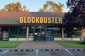
Blockbuster (Bend, Oregon)
Blockbuster video store in Bend, Oregon, U.S.
Distance: Approx. 3604 meters
Latitude and longitude: 44.06722222,-121.30361111
Blockbuster, colloquially known as the Last Blockbuster, is a video rental store in Bend, Oregon. In 2018, it became the last Blockbuster store in the United States, and in 2019, it became the world's last remaining retail store using the Blockbuster brand.
Weather in this IP's area
clear sky
-14 Celsius
-14 Celsius
-19 Celsius
-13 Celsius
1026 hPa
87 %
1026 hPa
890 hPa
10000 meters
0.89 m/s
1.34 m/s
317 degree
5 %