Country:
 USA
USARegion:
City:
Latitude and Longitude:
Time Zone:
Postal Code:
IP information under different IP Channel
ip-api
Country
Region
City
ASN
Time Zone
ISP
Blacklist
Proxy
Latitude
Longitude
Postal
Route
IPinfo
Country
Region
City
ASN
Time Zone
ISP
Blacklist
Proxy
Latitude
Longitude
Postal
Route
MaxMind
Country
Region
City
ASN
Time Zone
ISP
Blacklist
Proxy
Latitude
Longitude
Postal
Route
Luminati
Country
USRegion
mi
City
farmingtonhills
ASN
Time Zone
America/Detroit
ISP
123NET
Latitude
Longitude
Postal
db-ip
Country
Region
City
ASN
Time Zone
ISP
Blacklist
Proxy
Latitude
Longitude
Postal
Route
ipdata
Country
Region
City
ASN
Time Zone
ISP
Blacklist
Proxy
Latitude
Longitude
Postal
Route
Popular places and events near this IP address
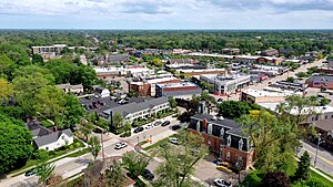
Farmington, Michigan
City in Michigan, United States
Distance: Approx. 1906 meters
Latitude and longitude: 42.46444444,-83.37638889
Farmington is a city in Oakland County in the U.S. state of Michigan. A northwestern suburb of Detroit, Farmington is located roughly 20 miles (32.2 km) from downtown Detroit, and is surrounded on most sides by the larger city of Farmington Hills. As of the 2020 census, the city had a population of 11,594.

Farmington Hills, Michigan
City in Michigan, United States
Distance: Approx. 3162 meters
Latitude and longitude: 42.48527778,-83.37694444
Farmington Hills is a city in Oakland County in the U.S. state of Michigan. A northwestern suburb of Detroit, Farmington Hills is located roughly 22 miles (35.4 km) from downtown Detroit. As of the 2020 census, the city's population was 83,986, making it the second-largest community in Oakland County.
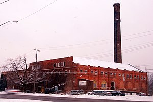
Farmington Winery (Michigan)
Winery
Distance: Approx. 3488 meters
Latitude and longitude: 42.45643,-83.35766
The Farmington Winery was the former LaSalle Winery which was operated in the converted Detroit United Railway Powerhouse in Farmington, Michigan. Production ceased in the late 1960s and the building was used primarily as a distribution center. Later, the St Julian Winery purchased the LaSalle brand.
William Tyndale College
Distance: Approx. 4087 meters
Latitude and longitude: 42.49888889,-83.40111111
William Tyndale College was a private nondenominational Christian college located in Farmington Hills, Michigan, United States. Named after 16th-century Protestant scholar William Tyndale, the college was founded as the Detroit Bible Institute in 1945, and became accredited by the American Association of Bible Colleges in 1954 and North Central Association of Colleges and Schools in 1988. William Tyndale College closed on December 31, 2004.
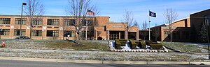
Farmington High School (Michigan)
Public high school in Farmington, Michigan, United States
Distance: Approx. 3127 meters
Latitude and longitude: 42.46388889,-83.36138889
Farmington High School is a public high school located in Farmington, Michigan. The school was established in 1888, and the first sections of the current building were built in 1953, with several renovations and additions occurring since then. As of the 2022–2023 school year, the school educates a student body of 1,400.
Waza FC
Indoor soccer team
Distance: Approx. 3636 meters
Latitude and longitude: 42.43,-83.392
The Waza FC (also known as Detroit Waza) is an American professional arena soccer team based in Metro Detroit competing as a charter member of the Major League Indoor Soccer (MLIS). The team's nickname, "Waza", is both a Japanese word that means "good technique" (技) and a Swahili word meaning "to think clearly".

Glen Eden Lutheran Memorial Park
Cemetery in Michigan
Distance: Approx. 2855 meters
Latitude and longitude: 42.43655556,-83.39966667
Glen Eden Lutheran Memorial Park is a non-profit cemetery in Livonia, Michigan and Macomb Township. Glen Eden began serving the community when a small group of investors started the cemetery in 1929. In 1932, a twist of fate transferred ownership and operation of the cemetery to four Lutheran churches.

Farmington Historic District (Farmington, Michigan)
Historic district in Michigan, United States
Distance: Approx. 1792 meters
Latitude and longitude: 42.46555556,-83.37805556
Farmington Historic District is the town center of Farmington, Michigan. It was listed on the National Register of Historic Places in 1976. The area roughly corresponds to the section of Grand River Avenue and Shiawassee Avenue from Warner Street to junction of Grand River and Shiawassee.

Greenmead Farms
Historic house in Michigan, United States
Distance: Approx. 3094 meters
Latitude and longitude: 42.43805556,-83.41805556
Greenmead Historical Park, also known as Greenmead Farms, is a 3.2-acre (1.3 ha) historic park located at 38125 Base Line Rd., Livonia, Michigan. It includes the 1841 Greek Revival Simmons House, six other structures contributing to the historic nature of the property, and additional buildings moved from other locations. Greenmead Farms was designated a Michigan State Historic Site in 1971 and listed on the National Register of Historic Places in 1972.
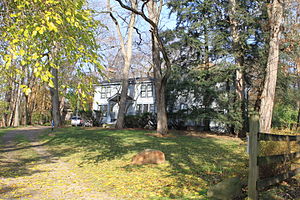
Botsford-Graser House
United States historic place
Distance: Approx. 1522 meters
Latitude and longitude: 42.47027778,-83.38444444
The Botsford-Graser House is a single-family home located at 24105 Locust Drive in Farmington Hills, Michigan. It was listed on the National Register of Historic Places in 2002. The house is significant in part as the home of Earle Graser, the voice of the Lone Ranger for some 13,000 performances on radio, and is also known as The Lone Ranger's House.

First United Methodist Church (Farmington, Michigan)
United States historic place
Distance: Approx. 2129 meters
Latitude and longitude: 42.46416667,-83.37361111
The First United Methodist Church is a church located at 33112 Grand River Avenue in Farmington, Michigan. It was listed on the National Register of Historic Places in 2014.
St. Toma Syriac Catholic Cathedral
Church in Michigan, United States
Distance: Approx. 2277 meters
Latitude and longitude: 42.48263889,-83.39841667
St. Toma Cathedral is a Syriac Catholic cathedral located in Farmington Hills, Michigan, United States. It is the seat of the Eparchy of Our Lady of Deliverance in the United States.
Weather in this IP's area
clear sky
6 Celsius
6 Celsius
5 Celsius
8 Celsius
1020 hPa
93 %
1020 hPa
990 hPa
10000 meters
0.45 m/s
2.24 m/s
262 degree
3 %
07:06:44
19:55:50