Country:
 USA
USARegion:
City:
Latitude and Longitude:
Time Zone:
Postal Code:
IP information under different IP Channel
ip-api
Country
Region
City
ASN
Time Zone
ISP
Blacklist
Proxy
Latitude
Longitude
Postal
Route
IPinfo
Country
Region
City
ASN
Time Zone
ISP
Blacklist
Proxy
Latitude
Longitude
Postal
Route
MaxMind
Country
Region
City
ASN
Time Zone
ISP
Blacklist
Proxy
Latitude
Longitude
Postal
Route
Luminati
Country
USRegion
mi
City
annarbor
ASN
Time Zone
America/Detroit
ISP
123NET
Latitude
Longitude
Postal
db-ip
Country
Region
City
ASN
Time Zone
ISP
Blacklist
Proxy
Latitude
Longitude
Postal
Route
ipdata
Country
Region
City
ASN
Time Zone
ISP
Blacklist
Proxy
Latitude
Longitude
Postal
Route
Popular places and events near this IP address

Troy, Michigan
City in Michigan, United States
Distance: Approx. 1935 meters
Latitude and longitude: 42.58027778,-83.14305556
Troy is a city in Oakland County in the U.S. state of Michigan. A northern suburb of Detroit, Troy is located about 22 miles (35 km) north of downtown Detroit. As of the 2020 census, the city had a population of 87,294, making Troy the largest community in Oakland County, and the 13th-most-populous municipality in the state.
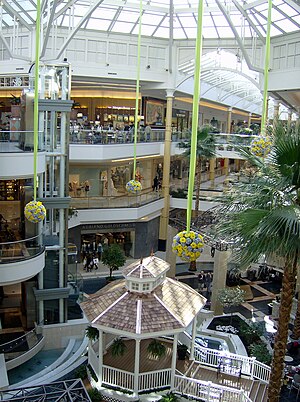
Somerset Collection
Luxury shopping mall in Michigan, U.S.
Distance: Approx. 3336 meters
Latitude and longitude: 42.56138889,-83.18388889
Somerset Collection is a shopping mall of more than 180 retailers located in Troy, Michigan, part of Metro Detroit. Somerset Collection is developed, managed, and co-owned by The Forbes Company, and is among the most profitable malls in the United States not owned by a real estate investment trust. (Of the 100 most profitable American malls, 76 are owned by real estate investment trusts.) The mall hosts the traditional mall retail anchor tenants Macy's, Nordstrom, Saks Fifth Avenue, and Neiman Marcus, along with specialty retailers like Allbirds, Altar'd State, and Vuori, and luxury brands including Dior, Saint Laurent, Versace, and Hermès.
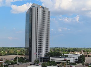
PNC Center (Troy, Michigan)
High-rise office building in Michigan, US
Distance: Approx. 3067 meters
Latitude and longitude: 42.56027778,-83.16083333
PNC Center, formerly National City Center and often still known by its original name, the Top of Troy, is a high-rise office building in Troy, Michigan. The complex consists of a 25-story triangular office tower and a two-floor atrium containing offices, retail, and a conference center. Completed in 1975, the International-style tower is the tallest building in Troy and among the tallest in Oakland County, standing 346 feet tall with 667,000 square feet of office space.
The Centennial (Troy)
Distance: Approx. 3211 meters
Latitude and longitude: 42.5622,-83.1461
The Centennial, also known as the SBC Publishing Building or 100 North Center, is a tall office building in Troy, Michigan. It is located at 100 E. Big Beaver Road, North of I-75. The high-rise was built in 1981 and finished in 1983.
Columbia Center (Troy)
Pair of towers in Troy, Michigan, US
Distance: Approx. 3223 meters
Latitude and longitude: 42.5607,-83.1502
The Columbia Center is a pair of twin towers on Big Beaver Road in Troy, Michigan. Both buildings were designed by Minoru Yamasaki & Associates, designers of One Woodward Avenue and the now-destroyed World Trade Center. Both buildings stand 14 floors and are 193 ft (59m) tall.
Troy High School (Michigan)
Public secondary school in Troy, Michigan, United States
Distance: Approx. 2689 meters
Latitude and longitude: 42.566,-83.15
Troy High School (THS) is a public high school in Troy, Michigan, United States. It enrolls approximately 2,000 students in grades 9–12. It is one of four high schools in the Troy School District, along with Athens High School, Troy College and Career School, and International Academy East.
Troy School District (Michigan)
School district in Michigan
Distance: Approx. 1528 meters
Latitude and longitude: 42.58347222,-83.14666667
The Troy School District is a public school district in Metro Detroit in the U.S. state of Michigan, serving most of Troy and a small portion of Bloomfield Township.

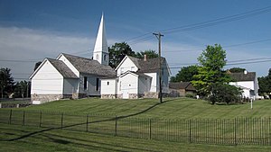
Barn Church (Troy, Michigan)
Church in Michigan
Distance: Approx. 1556 meters
Latitude and longitude: 42.58080556,-83.14788889
The Barn Church was built by William Lakie in Troy in Oakland County, Michigan in 1912 and was converted to a church when it stopped being used for its original function as a dairy barn. It is now a Michigan State Historic Site. Prior to its purchase by the Presbyterian Church in 1928, electric interurban cars would stop at the barn to pick up milk to take to market.
Troy Historic Village
Distance: Approx. 1630 meters
Latitude and longitude: 42.578,-83.1495
The Troy Historic Village is located in the city of Troy, Michigan. The establishment allows visitors to view the lifestyle of those who lived in Troy Township in the 1800s. The carefully restored buildings include the main building (City Hall), log cabin, a Greek Revival Home, a brick one-room school, print shop, wagon shop, a town hall, a general store, and a turn of the century church and parsonage.
Troy College and Career High School
Distance: Approx. 2129 meters
Latitude and longitude: 42.605,-83.15333333
Troy College and Career High School, formerly Niles Community High School, is a non-traditional public high school in Troy, Michigan. A part of Troy Public Schools, it is attended by approximately 150 students in and around Troy.

Caswell House (Troy, Michigan)
Historic house in Michigan, United States
Distance: Approx. 1567 meters
Latitude and longitude: 42.57777778,-83.15083333
The Caswell House is a single family house located at 60 W. Wattles Road in Troy, Michigan in the Troy Museum and Historic Village. It is an especially well-preserved example of Greek Revival architecture. It was designated a Michigan State Historic Site in 1969 and listed on the National Register of Historic Places in 1972.

Former Kmart headquarters
Former Kmart Headquarters
Distance: Approx. 3436 meters
Latitude and longitude: 42.5626,-83.1888
The former international headquarters of Kmart Corporation was located at 3100 W. Big Beaver Road in Troy, Michigan. The building, on the northwest side of the intersection of W. Big Beaver Road and Coolidge Highway, used to employ thousands of people, but had been vacant since 2006. The building was erected in 1969, designed by Smith, Hinchman, and Grylls, Inc.
Weather in this IP's area
clear sky
14 Celsius
13 Celsius
13 Celsius
16 Celsius
1031 hPa
62 %
1031 hPa
1005 hPa
10000 meters
1.96 m/s
2.92 m/s
171 degree
07:49:39
18:45:25