Country:
 USA
USARegion:
City:
Latitude and Longitude:
Time Zone:
Postal Code:
IP information under different IP Channel
ip-api
Country
Region
City
ASN
Time Zone
ISP
Blacklist
Proxy
Latitude
Longitude
Postal
Route
IPinfo
Country
Region
City
ASN
Time Zone
ISP
Blacklist
Proxy
Latitude
Longitude
Postal
Route
MaxMind
Country
Region
City
ASN
Time Zone
ISP
Blacklist
Proxy
Latitude
Longitude
Postal
Route
Luminati
Country
USASN
Time Zone
America/Chicago
ISP
123NET
Latitude
Longitude
Postal
db-ip
Country
Region
City
ASN
Time Zone
ISP
Blacklist
Proxy
Latitude
Longitude
Postal
Route
ipdata
Country
Region
City
ASN
Time Zone
ISP
Blacklist
Proxy
Latitude
Longitude
Postal
Route
Popular places and events near this IP address

Farmington Hills, Michigan
City in Michigan, United States
Distance: Approx. 1686 meters
Latitude and longitude: 42.48527778,-83.37694444
Farmington Hills is a city in Oakland County in the U.S. state of Michigan. A northwestern suburb of Detroit, Farmington Hills is located roughly 22 miles (35.4 km) from downtown Detroit. As of the 2020 census, the city's population was 83,986, making it the second-largest community in Oakland County.

The Zekelman Holocaust Center
Holocaust museum in the United States
Distance: Approx. 2357 meters
Latitude and longitude: 42.5024,-83.359
The Holocaust Memorial Center in Farmington Hills, Michigan, near Detroit, is Michigan's largest Holocaust museum.
William Tyndale College
Distance: Approx. 1143 meters
Latitude and longitude: 42.49888889,-83.40111111
William Tyndale College was a private nondenominational Christian college located in Farmington Hills, Michigan, United States. Named after 16th-century Protestant scholar William Tyndale, the college was founded as the Detroit Bible Institute in 1945, and became accredited by the American Association of Bible Colleges in 1954 and North Central Association of Colleges and Schools in 1988. William Tyndale College closed on December 31, 2004.
North Farmington High School
Public high school in Farmington Hills, Michigan, United States
Distance: Approx. 2021 meters
Latitude and longitude: 42.5144787,-83.3757669
North Farmington High School is a public high school located in Farmington Hills, Michigan. The school was established in 1961 and educates a student body of approximately 1,300. The principal is Joseph Greene.

Harrison High School (Michigan)
Former high school in Michigan, United States
Distance: Approx. 3374 meters
Latitude and longitude: 42.4975,-83.34611111
Harrison High School (also known as Farmington Harrison) was a four-year secondary institution located in Farmington Hills, Michigan. It was part of the Farmington Public School District serving students from the cities of Farmington, Farmington Hills, and a portion of West Bloomfield Township. The school closed in 2019, with the district citing declining enrollment.
Michigan School of Psychology
Private graduate school in Farmington Hills, Michigan, U.S.
Distance: Approx. 2413 meters
Latitude and longitude: 42.491482,-83.359344
The Michigan School of Psychology (MSP), formerly the Michigan School of Professional Psychology and the Center for Humanistic Studies, is a private graduate school in Farmington Hills, Michigan, which specializes in clinical psychology. It offers three programs of study: the Master of Arts (M.A.) in clinical psychology, which is offered in a one-year full-time or a two-year part-time format; the Doctor of Clinical Psychology (Psy.D.) degree, a full-time, minimum four-year, post-masters program; and a Certificate in Applied Behavior Analysis (ABA), a two-year certificate that can be completed concurrently with the MA program in clinical psychology.
Farmington Community Library
Distance: Approx. 1339 meters
Latitude and longitude: 42.498,-83.3709
Farmington Community Library is a public library system in Farmington Hills, Michigan in Greater Detroit. The main library is in Farmington Hills and one of the branches is in Farmington, Michigan.
Oakland Early College
Distance: Approx. 1577 meters
Latitude and longitude: 42.49261111,-83.36966667
Oakland Early College (OEC) is a five-year early college high school serving students throughout Oakland County, Michigan. It represents a partnership between the West Bloomfield School District and Oakland Community College's (OCC) Orchard Ridge campus. Newsweek's annual ranking of public schools in America ranked OEC as #159.
Quakertown North, Michigan
Former census-designated place & unincorporated community in Michigan, United States
Distance: Approx. 2473 meters
Latitude and longitude: 42.52027778,-83.38194444
Quakertown North was a census-designated place in Oakland County, Michigan during the 1970 United States Census. The population in recorded was 7,101. The census area, along with the neighboring communities merged to the newly created city Farmington Hills in 1973.

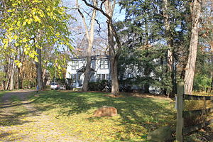
Royal Aldrich House
United States historic place
Distance: Approx. 2917 meters
Latitude and longitude: 42.485,-83.35666667
The Royal Aldrich House is a single-family house located at 31110 West 11 Mile Road in Farmington Hills, Michigan. It was listed on the National Register of Historic Places in 1994. It is one of a few remaining Greek Revival style houses in southeast Michigan still located on the site where built.
Botsford-Graser House
United States historic place
Distance: Approx. 3139 meters
Latitude and longitude: 42.47027778,-83.38444444
The Botsford-Graser House is a single-family home located at 24105 Locust Drive in Farmington Hills, Michigan. It was listed on the National Register of Historic Places in 2002. The house is significant in part as the home of Earle Graser, the voice of the Lone Ranger for some 13,000 performances on radio, and is also known as The Lone Ranger's House.
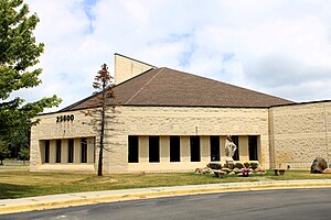
St. Toma Syriac Catholic Cathedral
Church in Michigan, United States
Distance: Approx. 1981 meters
Latitude and longitude: 42.48263889,-83.39841667
St. Toma Cathedral is a Syriac Catholic cathedral located in Farmington Hills, Michigan, United States. It is the seat of the Eparchy of Our Lady of Deliverance in the United States.
Weather in this IP's area
haze
13 Celsius
12 Celsius
12 Celsius
15 Celsius
1031 hPa
61 %
1031 hPa
1000 hPa
2816 meters
1.54 m/s
150 degree
07:50:26
18:46:25