Country:
 USA
USARegion:
City:
Latitude and Longitude:
Time Zone:
Postal Code:
IP information under different IP Channel
ip-api
Country
Region
City
ASN
Time Zone
ISP
Blacklist
Proxy
Latitude
Longitude
Postal
Route
IPinfo
Country
Region
City
ASN
Time Zone
ISP
Blacklist
Proxy
Latitude
Longitude
Postal
Route
MaxMind
Country
Region
City
ASN
Time Zone
ISP
Blacklist
Proxy
Latitude
Longitude
Postal
Route
Luminati
Country
USRegion
mi
City
grosseiletownship
ASN
Time Zone
America/Detroit
ISP
123NET
Latitude
Longitude
Postal
db-ip
Country
Region
City
ASN
Time Zone
ISP
Blacklist
Proxy
Latitude
Longitude
Postal
Route
ipdata
Country
Region
City
ASN
Time Zone
ISP
Blacklist
Proxy
Latitude
Longitude
Postal
Route
Popular places and events near this IP address

Grosse Ile Township, Michigan
Civil township in Michigan, United States
Distance: Approx. 573 meters
Latitude and longitude: 42.13,-83.16027778
Grosse Ile Township is a civil township of Wayne County in the U.S. state of Michigan. The population was 10,777 at the 2020 census. The township encompasses several islands in the Detroit River, of which the largest is named as Grosse Ile.

Trenton, Michigan
City in Michigan, United States
Distance: Approx. 1644 meters
Latitude and longitude: 42.13944444,-83.17833333
Trenton is a city in Wayne County, Michigan, United States. At the 2010 census, the city population was 18,853. A Shawnee village was built in the area by war chief Blue Jacket after the 1795 Treaty of Greenville.

Battle of Maguaga
Distance: Approx. 1947 meters
Latitude and longitude: 42.13609,-83.18285
The Battle of Maguaga (also known as the Battle of Monguagon or the Battle of the Oakwoods) was a small battle between British troops, Canadian militia and Tecumseh's natives against a larger force of American troops, Ohio Volunteers and Michigan Legion near the Wyandot village of Maguaga which become The Township of Monguagon Township, Michigan in what is now The City of Riverview, Michigan.

Wayne County Bridge
Bridge in Wayne County, Michigan
Distance: Approx. 1568 meters
Latitude and longitude: 42.12755556,-83.17533333
The Wayne County Bridge is a swing bridge that crosses the Trenton Channel in the Detroit River. Located in Wayne County, Michigan, it connects Grosse Ile Township to mainland Trenton and is one of two bridges connecting the island of Grosse Ile to the mainland — the other being the tolled Grosse Ile Toll Bridge to the north. Locally, it is also known as "The Free Bridge".
Riverside Osteopathic Hospital
Hospital in Michigan, United States
Distance: Approx. 2018 meters
Latitude and longitude: 42.149,-83.175
Riverside Osteopathic Hospital was an osteopathic hospital located in Trenton, Michigan. The hospital was closed in 2002. As of August 2023, the building is currently being demolished.
Grosse Ile (Michigan)
Distance: Approx. 573 meters
Latitude and longitude: 42.13,-83.16027778
Grosse Ile ( grows-EEL) is an American island in Wayne County in the U.S. state of Michigan. Located just west of the Canada–United States border in the Detroit River, it is the largest island in the river and the most-populated island in the state of Michigan. The island is administered by Grosse Ile Township.

Elizabeth Park (Michigan)
Distance: Approx. 1761 meters
Latitude and longitude: 42.13222222,-83.18027778
Elizabeth Park is a county-owned public park in southeast Wayne County in the U.S. state of Michigan. The park is located in the city of Trenton along West Jefferson Avenue and the Detroit River just north of the Wayne County Bridge leading to Grosse Ile. Under private ownership until it was given to the county in 1919, Elizabeth Park is recognized as the first county park established in the state of Michigan.
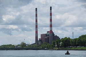
Trenton Channel Power Plant
Distance: Approx. 2320 meters
Latitude and longitude: 42.12222222,-83.18138889
The Trenton Channel Power Plant, also known as the Trenton Stacks, was a coal-burning power station located in Trenton, Michigan. Completed in 1924, it is owned by Detroit Edison, a subsidiary of DTE Energy.

St. James Episcopal Church (Grosse Ile, Michigan)
Historic church in Michigan, United States
Distance: Approx. 1805 meters
Latitude and longitude: 42.12472222,-83.1425
The St. James Episcopal Church is a church located at 25150 East River Road in Grosse Ile, Michigan, United States. It was listed on the National Register of Historic Places designated a Michigan State Historic Site in 1971.

Ferry Street–Thorofare Canal bridge
United States historic place
Distance: Approx. 407 meters
Latitude and longitude: 42.13805556,-83.15638889
The Ferry Street Bridge or Ferry Street–Thorofare Canal bridge is a bridge located at Ferry Street over the Thorofare Canal in Grosse Ile, Michigan. It was listed on the National Register of Historic Places in 2000.

East River Road Historic District
Historic house in Michigan, United States
Distance: Approx. 1784 meters
Latitude and longitude: 42.12583333,-83.14166667
The East River Road Historic District is a historic district located along East River Road near the Grosse Ile Parkway in Grosse Ile, Michigan. The district is a small island community composed of eleven structures, including seven houses, two outbuildings, St. James Episcopal Church, and the Michigan Central Railroad depot.

Stony Island (Michigan)
Island in the Detroit River, Michigan
Distance: Approx. 2462 meters
Latitude and longitude: 42.12583333,-83.13222222
Stony Island is an island in the Detroit River, in southeast Michigan. It has been used for hunting and fishing as long as humans have inhabited the region; from the mid-19th century to the mid-20th century, it was the site of a small settlement and served as a central location for the construction of the Livingstone Channel, as well as various civil engineering projects involving the Detroit River. By the 1990s, it had become completely uninhabited; it is now open to the public and administered by the Michigan Department of Natural Resources.
Weather in this IP's area
clear sky
7 Celsius
5 Celsius
5 Celsius
8 Celsius
1020 hPa
91 %
1020 hPa
998 hPa
10000 meters
3.09 m/s
260 degree
07:06:01
19:54:37