Country:
 USA
USARegion:
City:
Latitude and Longitude:
Time Zone:
Postal Code:
IP information under different IP Channel
ip-api
Country
Region
City
ASN
Time Zone
ISP
Blacklist
Proxy
Latitude
Longitude
Postal
Route
IPinfo
Country
Region
City
ASN
Time Zone
ISP
Blacklist
Proxy
Latitude
Longitude
Postal
Route
MaxMind
Country
Region
City
ASN
Time Zone
ISP
Blacklist
Proxy
Latitude
Longitude
Postal
Route
Luminati
Country
USASN
Time Zone
America/Chicago
ISP
AHOSTING
Latitude
Longitude
Postal
db-ip
Country
Region
City
ASN
Time Zone
ISP
Blacklist
Proxy
Latitude
Longitude
Postal
Route
ipdata
Country
Region
City
ASN
Time Zone
ISP
Blacklist
Proxy
Latitude
Longitude
Postal
Route
Popular places and events near this IP address

Clawson, Michigan
City in Michigan, United States
Distance: Approx. 2540 meters
Latitude and longitude: 42.53333333,-83.14638889
Clawson is a city in Oakland County in the U.S. state of Michigan. A northern suburb of Detroit, Clawson is located about 19 miles (31 km) north of downtown Detroit. As of the 2020 census, the city had a population of 11,389.
Shrine Catholic Schools
Private, coeducational school
Distance: Approx. 2084 meters
Latitude and longitude: 42.5183,-83.1898
Shrine Catholic Schools is a private, co-educational Catholic school serving preschool through grade 12. It is located in Royal Oak, Michigan,and affiliated with National Shrine of the Little Flower. The school consists of Shrine Catholic Grade School on one campus and Shrine Catholic Academy (middle school) and Shrine Catholic High School on another campus.
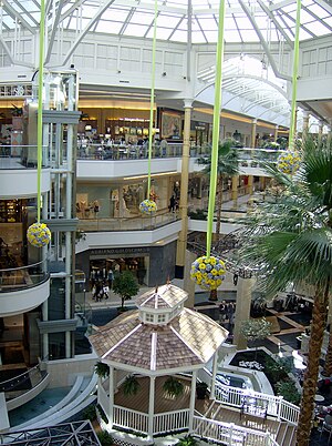
Somerset Collection
Luxury shopping mall in Michigan, U.S.
Distance: Approx. 3031 meters
Latitude and longitude: 42.56138889,-83.18388889
Somerset Collection is a shopping mall of more than 180 retailers located in Troy, Michigan, part of Metro Detroit. Somerset Collection is developed, managed, and co-owned by The Forbes Company, and is among the most profitable malls in the United States not owned by a real estate investment trust. (Of the 100 most profitable American malls, 76 are owned by real estate investment trusts.) The mall hosts the traditional mall retail anchor tenants Macy's, Nordstrom, Saks Fifth Avenue, and Neiman Marcus, along with specialty retailers like Allbirds, Altar'd State, and Vuori, and luxury brands including Dior, Saint Laurent, Versace, and Hermès.
Oakland/Troy Airport
Airport in Michigan, United States
Distance: Approx. 942 meters
Latitude and longitude: 42.54305556,-83.17777778
Oakland/Troy Airport (ICAO: KVLL, FAA LID: VLL) is a county-owned public-use airport located two miles (3.2 km) east of the central business district of Troy, a city in Oakland County, Michigan, United States. It is included in the Federal Aviation Administration (FAA) National Plan of Integrated Airport Systems for 2017–2021, in which it is categorized as a regional reliever airport facility. The Oakland/Troy Airport is considered the county's "executive" airport.
Royal Oak High School
High school in Michigan, United States
Distance: Approx. 1775 meters
Latitude and longitude: 42.52277778,-83.16277778
Royal Oak High School (ROHS) is a public high school located in Royal Oak, Michigan. The interim principal is Angela Ashburn. It is a part of Royal Oak Neighborhood Schools.

Birmingham station (Michigan)
Distance: Approx. 1844 meters
Latitude and longitude: 42.54555556,-83.19416667
Birmingham was an Amtrak train station in Birmingham, Michigan, served by the Wolverine service. The station was located on an embankment at the eastern end of Villa Road, and consisted of a concrete platform with a small shelter and wheelchair lift. On October 13, 2014, the station was closed and replaced by the Troy Transit Center, located about 1,200 feet (370 m) southeast on Doyle Drive in Troy, Michigan.

Corewell Health William Beaumont University Hospital
Hospital in Royal Oak, Michigan, US
Distance: Approx. 2556 meters
Latitude and longitude: 42.5146,-83.1926
Corewell Health William Beaumont University Hospital is a nationally ranked, 1131 bed non-profit, acute care teaching hospital located in Royal Oak, Michigan, providing tertiary care and healthcare services to the Royal Oak region and Metro Detroit. Corewell Health William Beaumont University Hospital is the flagship facility of Corewell Health. The hospital is affiliated with the Oakland University William Beaumont School of Medicine, as the primary teaching affiliate.

Troy Transit Center
Train station
Distance: Approx. 1434 meters
Latitude and longitude: 42.5425,-83.19111111
The Troy Transit Center is an unstaffed train station in Troy, Michigan, United States, that is served by Amtrak's Wolverine, which runs thrice daily between Chicago, Illinois, and Pontiac, Michigan (via Kalamazoo, Ann Arbor, and Detroit, Michigan). It is also served by Suburban Mobility Authority for Regional Transportation (SMART). The transit center replaced the nearby Birmingham Amtrak station in October 2014.
Clarence M. Kimball High School
Public school
Distance: Approx. 1800 meters
Latitude and longitude: 42.52305556,-83.16194444
Clarence M. Kimball High School was a secondary educational facility located in Royal Oak, Michigan, in Greater Detroit and had 1,10 students at the time of its consolidation with Dondero High School following the 2005-06 school year to form Royal Oak High School, which occupies the former Kimball High School building. The final principal was Michael Greening. It was a part of Royal Oak Neighborhood Schools.

Grand Trunk Western Railroad Depot (Birmingham, Michigan)
United States historic place
Distance: Approx. 1978 meters
Latitude and longitude: 42.54666667,-83.195
The Grand Trunk Western Railroad Birmingham Depot is a former railroad train station located at 245 South Eton Street in Birmingham, Michigan. It was listed on the National Register of Historic Places in 1985. As of 2022, the building is unoccupied.

Derby Street-Grand Trunk Western Railroad Bridge
United States historic place
Distance: Approx. 3034 meters
Latitude and longitude: 42.55416667,-83.20305556
The Derby Street-Grand Trunk Western Railroad Bridge is a bridge carrying Derby Street over the Grand Trunk Western Railroad in Birmingham, Michigan. It was listed on the National Register of Historic Places in 2000.
Noori Pocha
Restaurant in Clawson, Michigan, U.S.
Distance: Approx. 2580 meters
Latitude and longitude: 42.5333,-83.1459
Noori Pocha is a restaurant in Clawson, Michigan. It was included in The New York Times's 2024 list of the 50 best restaurants in the United States.
Weather in this IP's area
clear sky
11 Celsius
10 Celsius
9 Celsius
12 Celsius
1016 hPa
56 %
1016 hPa
991 hPa
10000 meters
2.57 m/s
280 degree
07:36:54
19:03:34