Country:
Region:
City:
Latitude and Longitude:
Time Zone:
Postal Code:
IP information under different IP Channel
ip-api
Country
Region
City
ASN
Time Zone
ISP
Blacklist
Proxy
Latitude
Longitude
Postal
Route
Luminati
Country
Region
de
City
wilmington
ASN
Time Zone
America/New_York
ISP
INTERNAP-BLK3
Latitude
Longitude
Postal
IPinfo
Country
Region
City
ASN
Time Zone
ISP
Blacklist
Proxy
Latitude
Longitude
Postal
Route
db-ip
Country
Region
City
ASN
Time Zone
ISP
Blacklist
Proxy
Latitude
Longitude
Postal
Route
ipdata
Country
Region
City
ASN
Time Zone
ISP
Blacklist
Proxy
Latitude
Longitude
Postal
Route
Popular places and events near this IP address

Episcopal Diocese of Delaware
Diocese of the Episcopal Church in the United States
Distance: Approx. 388 meters
Latitude and longitude: 39.752833,-75.542178
The Episcopal Church in Delaware, formerly known as the Episcopal Diocese of Delaware, is one of 108 dioceses making up the Episcopal Church in the United States of America. It consists of 33 congregations or parishes in an area the same as the State of Delaware. The diocese is led by a bishop and staff and provides episcopal supervision and some administrative assistance for its parishes.

1201 North Market Street
Building in Wilmington, Delaware, USA
Distance: Approx. 294 meters
Latitude and longitude: 39.748,-75.547
1201 North Market Street is a 110 m (360 ft), 23-story high rise building or skyscraper in Wilmington, Delaware. It is the tallest building in Wilmington and the state of Delaware. The tower was designed by the architectural firm of Skidmore, Owings & Merrill and opened in 1988.

Corporation Trust Center
Building in Delaware, United States
Distance: Approx. 286 meters
Latitude and longitude: 39.74847,-75.54764
The Corporation Trust Center is operated by CT Corporation, a subsidiary of Dutch information services firm Wolters Kluwer. The company provides "registered agent services" and, as such, is not responsible for the business or legal affairs of the customers it serves. In 2012, it was the registered agent address of at least 285,000 separate American and foreign businesses who operate or trade in the United States.
Old First Presbyterian Church (Wilmington, Delaware)
Historic church in Delaware, United States
Distance: Approx. 193 meters
Latitude and longitude: 39.750772,-75.547472
Old First Presbyterian Church of Wilmington is a historic Presbyterian church located on West Street on Brandywine Park Drive in Wilmington, New Castle County, Delaware. Built in 1740, the one-story brick structure measures 30 feet by 40 feet and has a gambrel roof. Originally located on the east side of Wilmington's Market Street between 9th and 10th Streets, the building was used during the American Revolution by British troops as a prison and hospital during the occupation of Wilmington after the Battle of Brandywine, September 12, 1777.

United States Post Office, Courthouse, and Customhouse (Wilmington, Delaware)
United States historic place
Distance: Approx. 421 meters
Latitude and longitude: 39.74666667,-75.54666667
The U.S. Post Office, Courthouse, and Customhouse, also known as Main Post Office and the Wilmington Trust Headquarters, is a historic post office, courthouse, and custom house, located on Rodney Square in Wilmington, New Castle County, Delaware. It was designed by Irwin & Leighton in 1933–1935, and building was completed in 1937. It is in the Classical Revival.
Starr House (Wilmington, Delaware)
Historic house in Delaware, United States
Distance: Approx. 245 meters
Latitude and longitude: 39.748141,-75.544741
Starr House, also known as the Michael VanKirk House, is a historic home located at Wilmington, New Castle County, Delaware. It was built between 1801 and 1806, and is 2+1⁄2-story, brick dwelling with a gable roof. The house was restored in 1946 and considered the last example of colonial architecture in the city of Wilmington.
Wilmington Club
United States historic place
Distance: Approx. 418 meters
Latitude and longitude: 39.74694444,-75.5475
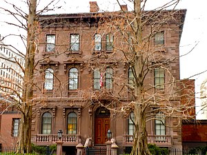
Wilmington Club, also known as the John Merrick House, is a historic clubhouse located at Wilmington, New Castle County, Delaware, United States. It was designed by architect Thomas Dixon and built in 1863, as a three-story, five bay "T"-plan brownstone dwelling in the Italianate style. The Wilmington Club purchased the building in 1900, and expanded it between 1936 and 1950 and in 1966.

Torbert Street Livery Stables
United States historic place
Distance: Approx. 401 meters
Latitude and longitude: 39.749234,-75.549773
Torbert Street Livery Stables, also known as Hercules Powder Company Printing Department, Charles Printing Co., Wilmington Motorcycle Club, Cann Bros & Kindig Printers, and Barclay Bros Printing, is a historic livery stable located at Wilmington, New Castle County, Delaware. It was built in 1887, and consists of two separately-built, two-story livery stables, joined and expanded through additions and internal alterations. A connecting hyphen was built during or after 1946.
Brandywine Village Historic District
Historic district in Delaware, United States
Distance: Approx. 347 meters
Latitude and longitude: 39.75111111,-75.54138889
Brandywine Village Historic District is a national historic district located along Brandywine Creek at Wilmington, New Castle County, Delaware. It encompasses 12 contributing buildings, 7 contributing sites, and 2 contributing structures. Brandywine Village developed in the late-18th century as a group of flour mills, the homes of prosperous millers, mill workers, shop keepers and artisans.
East Brandywine Historic District
Historic district in Delaware, United States
Distance: Approx. 343 meters
Latitude and longitude: 39.74861111,-75.54194444
East Brandywine Historic District is a national historic district located at Wilmington, New Castle County, Delaware. It encompasses 189 contributing buildings located east of the central business district of Wilmington dating from the late-18th to the early-20th century. The buildings reflect a mix of architectural types and styles include industrial buildings, churches, schools, semi-detached houses, rowhouses, apartment houses, restaurants, and stores.

Brandywine Village
Distance: Approx. 438 meters
Latitude and longitude: 39.75222222,-75.54083333
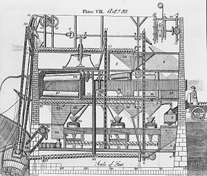
Brandywine Village was an early center of U.S. industrialization located on the Brandywine River in what is now Wilmington, Delaware. The Brandywine crosses the Fall Line just north of Wilmington, and descends from about 160 feet (49 m) above sea level in Chadds Ford to just a few feet above sea level in Wilmington. The river's descent allowed manufacturers — notably, of flour and gunpowder — to use high-powered machinery in the days before the steam engine, while its navigable channel to the Delaware River and Delaware Bay allowed them to load oceangoing ships.

I. M. Pei Building
Office in Wilmington, Delaware
Distance: Approx. 368 meters
Latitude and longitude: 39.7473,-75.5471
The I. M. Pei Building, also known as the Wilmington Tower, is a high-rise office building in Wilmington, Delaware. It is the third tallest building in Delaware, and the only building in the state designed by noted architect I. M. Pei. The building was completed in 1971 and is 282 feet (86 m) tall, with 23 floors.
Weather in this IP's area
clear sky
5 Celsius
3 Celsius
4 Celsius
6 Celsius
1019 hPa
68 %
1019 hPa
1018 hPa
10000 meters
2.57 m/s
290 degree
06:49:44
16:45:04


