Country:
 Israel
Region:
City:
Latitude and Longitude:
Time Zone:
Postal Code:
IP information under different IP Channel
ip-api
Country
Region
City
ASN
Time Zone
ISP
Blacklist
Proxy
Latitude
Longitude
Postal
Route
IPinfo
Country
Region
City
ASN
Time Zone
ISP
Blacklist
Proxy
Latitude
Longitude
Postal
Route
MaxMind
Country
Region
City
ASN
Time Zone
ISP
Blacklist
Proxy
Latitude
Longitude
Postal
Route
Luminati
Country
ILRegion
m
City
hodhasharon
ASN
Time Zone
Asia/Jerusalem
ISP
Cellcom Fixed Line Communication L.P
Latitude
Longitude
Postal
db-ip
Country
Region
City
ASN
Time Zone
ISP
Blacklist
Proxy
Latitude
Longitude
Postal
Route
ipdata
Country
Region
City
ASN
Time Zone
ISP
Blacklist
Proxy
Latitude
Longitude
Postal
Route
Popular places and events near this IP address

Battle of Arsuf
1191 battle of the Third Crusade
Distance: Approx. 3049 meters
Latitude and longitude: 32.2025,34.8125
The Battle of Arsuf took place on 7 September 1191, as part of the Third Crusade. It saw a multi-national force of Crusaders, led by Richard I of England, defeat a significantly larger army of the Ayyubid Sultanate, led by Saladin. Following the Crusaders' capture of Acre, Saladin moved to intercept Richard's advancing army just outside of the city of Arsuf (Arsur in Latin) as it moved along the coast from Acre towards Jaffa.
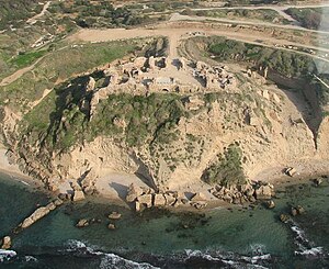
Apollonia–Arsuf
Ancient city in Tel Aviv District, Israel
Distance: Approx. 3967 meters
Latitude and longitude: 32.19527778,34.80666667
Apollonia (Ancient Greek: Ἀπολλωνία; Hebrew: אפולוניה), known in the Early Islamic period as Arsuf (Arabic: أرْسُوف, romanized: Arsūf) and in the Crusader Kingdom of Jerusalem as Arsur, was an ancient city on the Mediterranean coast of today's Israel. In Israeli archaeology it is known as Tel Arshaf (תֵּל אַרְשָׁף). Founded by the Phoenicians during the Persian period in the late sixth century BCE, it was inhabited continuously until the Crusader period, through the Hellenistic, Roman, and Byzantine periods, during the latter being renamed to Sozusa (Ancient Greek: Σώζουσα, or Sozusa in Palaestina to differentiate it from Sozusa in Libya).
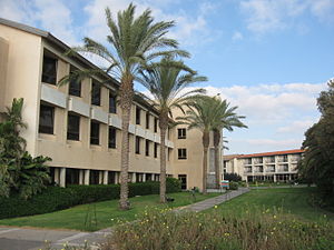
International Jewish Sports Hall of Fame
Sports hall of fame in Netanya, Israel
Distance: Approx. 3838 meters
Latitude and longitude: 32.26093611,34.83539444
The International Jewish Sports Hall of Fame (Hebrew: יד לאיש הספורט היהודי, romanized: Yad Le'ish HaSport HaYehudi) was opened July 7, 1981, in Netanya, Israel. It honors Jewish athletes and their accomplishments from anywhere around the world. It is located at the Wingate Institute for Physical Education and Sport.
Shefayim
Kibbutz in central Israel
Distance: Approx. 1432 meters
Latitude and longitude: 32.21722222,34.82444444
Shefayim (Hebrew: שְׁפָיִים, lit. High Hills) is a kibbutz in central Israel located 2.5 miles north of Herzliya along the Mediterranean coast. Shefayim falls under the jurisdiction of Hof HaSharon Regional Council.
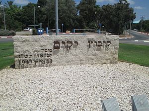
Yakum
Kibbutz in central Israel
Distance: Approx. 2986 meters
Latitude and longitude: 32.2475,34.8425
Yakum (Hebrew: יָקוּם, lit. "He (The People) shall rise") is a kibbutz in central Israel. Located in the central part of the Israeli coastal plain, about 30 km north of Tel Aviv, and only 5 km from the southern suburbs of Netanya, it falls under the jurisdiction of Hof HaSharon Regional Council.

Ga'ash
Kibbutz in central Israel
Distance: Approx. 625 meters
Latitude and longitude: 32.22916667,34.82583333
Ga'ash (Hebrew: גַּעַשׁ, lit. Storm) is a kibbutz in central Israel. Located in the coastal plain to the north of Tel Aviv, it falls under the jurisdiction of Hof HaSharon Regional Council.

Rishpon
Moshav in central Israel
Distance: Approx. 3070 meters
Latitude and longitude: 32.20194444,34.82333333
Rishpon (Hebrew: רִשְׁפּוֹן) is a moshav in the Central District of Israel. Located in the Sharon plain near Herzliya, it falls under the jurisdiction of Hof HaSharon Regional Council. In 2022 it had a population of 1,471.

Harutzim
Community settlement in central Israel
Distance: Approx. 4291 meters
Latitude and longitude: 32.2275,34.86472222
Harutzim (Hebrew: חָרוּצִים, lit. 'Diligents') is a community settlement in central Israel. Located in the Sharon plain near Ra'anana, it falls under the jurisdiction of Hof HaSharon Regional Council. In 2022 it had a population of 916.

Arsuf, Hof HaSharon
Village in central Israel
Distance: Approx. 4291 meters
Latitude and longitude: 32.2275,34.86472222
Arsuf (Hebrew: אַרְסוּף) is an affluent village in central Israel. Located on the Mediterranean coast near Herzliya, it falls under the jurisdiction of Hof HaSharon Regional Council. It was established in 1995, named after the medieval fortress city of Arsuf located nearby.

Khirbat al-Zababida
Place in Tulkarm, Mandatory Palestine
Distance: Approx. 3142 meters
Latitude and longitude: 32.25305556,34.83722222
Khirbat al-Zababida (Arabic: خربة الزبابدة, the Ruin of the People of Kafr Zibad) was a Palestinian Arab village in the Tulkarm Subdistrict. It was depopulated during the 1948 Arab–Israeli War on May 15, 1948. It was located 20 kilometres (12 mi) southwest of Tulkarm, south of Wadi al-Faliq.
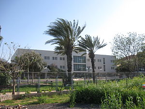
Kiryat Shlomo
Hospital in central Israel
Distance: Approx. 4009 meters
Latitude and longitude: 32.23416667,34.86138889
Kiryat Shlomo (Hebrew: קריית שלמה, lit. Place of Shlomo) is a psychiatric and geriatric hospital in Israel, that has the status of an institutional settlement. It falls within the jurisdiction of Hof HaSharon Regional Council and had a population of 374 in 2022.

First siege of Arsuf
Distance: Approx. 3972 meters
Latitude and longitude: 32.1952,34.8068
The first siege of Arsuf, originally Apollonia, took place in 1099, just after the First Crusade. It was carried out by Godfrey of Bouillon after the city failed to pay a previously agreed tribute. The attempt to capture the city failed for want of ships.
Weather in this IP's area
clear sky
21 Celsius
21 Celsius
21 Celsius
22 Celsius
1014 hPa
52 %
1014 hPa
1010 hPa
10000 meters
4.99 m/s
5.66 m/s
10 degree
06:47:15
18:03:42