Country:
Region:
City:
Latitude and Longitude:
Time Zone:
Postal Code:
IP information under different IP Channel
ip-api
Country
Region
City
ASN
Time Zone
ISP
Blacklist
Proxy
Latitude
Longitude
Postal
Route
Luminati
Country
ASN
Time Zone
America/Chicago
ISP
EXELA-25813
Latitude
Longitude
Postal
IPinfo
Country
Region
City
ASN
Time Zone
ISP
Blacklist
Proxy
Latitude
Longitude
Postal
Route
db-ip
Country
Region
City
ASN
Time Zone
ISP
Blacklist
Proxy
Latitude
Longitude
Postal
Route
ipdata
Country
Region
City
ASN
Time Zone
ISP
Blacklist
Proxy
Latitude
Longitude
Postal
Route
Popular places and events near this IP address

Clawson, Michigan
City in Michigan, United States
Distance: Approx. 1997 meters
Latitude and longitude: 42.53333333,-83.14638889
Clawson is a city in Oakland County in the U.S. state of Michigan. A northern suburb of Detroit, Clawson is located about 19 miles (31 km) north of downtown Detroit. As of the 2020 census, the city had a population of 11,389.

PNC Center (Troy, Michigan)
High-rise office building in Michigan, US
Distance: Approx. 4281 meters
Latitude and longitude: 42.56027778,-83.16083333
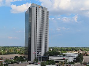
PNC Center, formerly National City Center and often still known by its original name, the Top of Troy, is a high-rise office building in Troy, Michigan. The complex consists of a 25-story triangular office tower and a two-floor atrium containing offices, retail, and a conference center. Completed in 1975, the International-style tower is the tallest building in Troy and among the tallest in Oakland County, standing 346 feet tall with 667,000 square feet of office space.
The Centennial (Troy)
Distance: Approx. 3658 meters
Latitude and longitude: 42.5622,-83.1461
The Centennial, also known as the SBC Publishing Building or 100 North Center, is a tall office building in Troy, Michigan. It is located at 100 E. Big Beaver Road, North of I-75. The high-rise was built in 1981 and finished in 1983.
Columbia Center (Troy)
Pair of towers in Troy, Michigan, US
Distance: Approx. 3717 meters
Latitude and longitude: 42.5607,-83.1502
The Columbia Center is a pair of twin towers on Big Beaver Road in Troy, Michigan. Both buildings were designed by Minoru Yamasaki & Associates, designers of One Woodward Avenue and the now-destroyed World Trade Center. Both buildings stand 14 floors and are 193 ft (59m) tall.
Royal Oak High School
High school in Michigan, United States
Distance: Approx. 3583 meters
Latitude and longitude: 42.52277778,-83.16277778
Royal Oak High School (ROHS) is a public high school located in Royal Oak, Michigan. The interim principal is Angela Ashburn. It is a part of Royal Oak Neighborhood Schools.
Troy High School (Michigan)
Public secondary school in Troy, Michigan, United States
Distance: Approx. 4187 meters
Latitude and longitude: 42.566,-83.15
Troy High School (THS) is a public high school in Troy, Michigan, United States. It enrolls approximately 2,000 students in grades 9–12. It is one of four high schools in the Troy School District, along with Athens High School, Troy College and Career School, and International Academy East.

Oakland Mall
Shopping mall in Michigan, U.S.
Distance: Approx. 952 meters
Latitude and longitude: 42.537,-83.111
Oakland Mall is an enclosed super-regional shopping mall located in the city of Troy, Michigan, a suburb of Detroit. It is located in the northwest corner of the intersection of 14 Mile and John R. roads, adjacent to Interstate 75 (Chrysler Freeway). The mall features 116 stores, including a food court, plus several big-box stores on the periphery.
Big Beaver Airport
Airport in Troy, Michigan
Distance: Approx. 3553 meters
Latitude and longitude: 42.564745,-83.108268
The Big Beaver Airport, formerly (IATA: 3BB), was a small suburban general aviation airport located at the corners of Big Beaver Road and John R Road in Troy, Michigan. It was created in 1946 as an auxiliary airfield with a 2,400 ft (220 m²) gravel runway. By the 1970s, the main airstrip was converted to asphalt and a 2,100 ft (200 m²) sod runway was added.
DMC Surgery Hospital
Hospital in Michigan, United States
Distance: Approx. 1860 meters
Latitude and longitude: 42.51785,-83.1202
DMC Surgery Hospital was one of the eight hospitals/Institutions composing the Detroit Medical Center. DMC Surgery Hospital was dedicated to the surgical needs of adults and children. Surgery for adults covered the full range of orthopaedic surgeries, neurosurgery relative to the spine and podiatric surgery.
Bishop Foley Catholic High School
Private school in Madison Heights, Michigan, United States
Distance: Approx. 719 meters
Latitude and longitude: 42.52833333,-83.12472222
Bishop Foley Catholic High School is a Catholic high school affiliated with the Roman Catholic Archdiocese of Detroit. Founded in 1965, it is named after the first American Bishop of Detroit, John Samuel Foley. It is located in Madison Heights, Michigan.
Clarence M. Kimball High School
Public school
Distance: Approx. 3508 meters
Latitude and longitude: 42.52305556,-83.16194444
Clarence M. Kimball High School was a secondary educational facility located in Royal Oak, Michigan, in Greater Detroit and had 1,10 students at the time of its consolidation with Dondero High School following the 2005-06 school year to form Royal Oak High School, which occupies the former Kimball High School building. The final principal was Michael Greening. It was a part of Royal Oak Neighborhood Schools.
Noori Pocha
Restaurant in Clawson, Michigan, U.S.
Distance: Approx. 1957 meters
Latitude and longitude: 42.5333,-83.1459
Noori Pocha is a Korean restaurant in Clawson, Michigan. It was included in The New York Times's 2024 list of the 50 best restaurants in the United States. Serena Maria Daniels incuded the restaurant in Eater Detroit's 2024 list of twelve "superb" restaurants for wings in Metro Detroit.
Weather in this IP's area
overcast clouds
11 Celsius
10 Celsius
10 Celsius
12 Celsius
1015 hPa
78 %
1015 hPa
991 hPa
10000 meters
2.57 m/s
90 degree
100 %
07:28:12
17:07:39