207.215.229.156 - IP Lookup: Free IP Address Lookup, Postal Code Lookup, IP Location Lookup, IP ASN, Public IP
Country:
Region:
City:
Location:
Time Zone:
Postal Code:
IP information under different IP Channel
ip-api
Country
Region
City
ASN
Time Zone
ISP
Blacklist
Proxy
Latitude
Longitude
Postal
Route
Luminati
Country
Region
md
City
hyattsville
ASN
Time Zone
America/New_York
ISP
NOWCOM-BGP
Latitude
Longitude
Postal
IPinfo
Country
Region
City
ASN
Time Zone
ISP
Blacklist
Proxy
Latitude
Longitude
Postal
Route
IP2Location
207.215.229.156Country
Region
california
City
los angeles
Time Zone
America/Los_Angeles
ISP
Language
User-Agent
Latitude
Longitude
Postal
db-ip
Country
Region
City
ASN
Time Zone
ISP
Blacklist
Proxy
Latitude
Longitude
Postal
Route
ipdata
Country
Region
City
ASN
Time Zone
ISP
Blacklist
Proxy
Latitude
Longitude
Postal
Route
Popular places and events near this IP address

Wilshire/Western station
Los Angeles Metro Rail station
Distance: Approx. 305 meters
Latitude and longitude: 34.0617,-118.3091
Wilshire/Western station is an underground rapid transit (known locally as a subway) station on the D Line of the Los Angeles Metro Rail system. It is located under Wilshire Boulevard at Western Avenue, after which the station is named, in the Mid-Wilshire and Koreatown districts of Los Angeles. It is the current western terminus of the D Line.

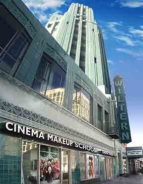
Pellissier Building and Wiltern Theatre
Los Angeles Historic-Cultural Monument
Distance: Approx. 428 meters
Latitude and longitude: 34.0611,-118.3078
The Pellissier Building and adjoining Wiltern Theatre is a 12-story, 155-foot (47 m) Art Deco landmark at the corner of Wilshire Boulevard and Western Avenue in Los Angeles, California. The entire complex is commonly referred to as the Wiltern Center. Clad in a blue-green glazed architectural terra-cotta tile and situated diagonal to the street corner, the complex is considered one of the finest examples of Art Deco architecture in the United States.

Getty House
Mayor's residence in California, United States
Distance: Approx. 617 meters
Latitude and longitude: 34.063272,-118.318779
The Getty House is the official residence of the mayor of Los Angeles, California. It is located at 605 South Irving Boulevard in Windsor Square, a historic district east of Hancock Park, about five miles west of the Los Angeles City Hall.
Le Privé
Distance: Approx. 398 meters
Latitude and longitude: 34.059012,-118.309422
Le Privé was a successful Korean club or "K-Club" in Los Angeles which was believed to be the largest Asian dance club in North America.

Cinema Makeup School
Private, for-profit makeup training school located in Los Angeles, USA
Distance: Approx. 301 meters
Latitude and longitude: 34.06194444,-118.30916667
Cinema Makeup School is a private, for-profit makeup training school located in Los Angeles. The school was founded in 1993. Specialties include beauty make-up for film and television as well as fashion and editorial purposes, hairstyling, airbrushing and bodypainting, character make-up, special make-up effects and prosthetics, creature maquette sculpture and digital makeup effects design, along with Advanced Lab Techniques and Advanced Beauty Techniques.

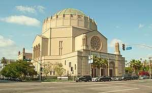
Wilshire Boulevard Temple
Reform Jewish synagogue in Los Angeles, California, US
Distance: Approx. 711 meters
Latitude and longitude: 34.06222222,-118.30472222
The Wilshire Boulevard Temple, known from 1862 to 1933 as Congregation B'nai B'rith, is a Reform Jewish congregation and synagogue, located at 3663 Wilshire Boulevard, in the Wilshire Center district of Los Angeles, California, in the United States. Founded in 1862, it is the oldest Jewish congregation in Los Angeles. The congregation's main building, with a sanctuary topped by a large Byzantine Revival dome and decorated with interior murals, was designated as a City of Los Angeles Historic Cultural Monument in 1973 and was listed on the National Register of Historic Places in 1981.
Los Altos Apartments
United States historic place
Distance: Approx. 471 meters
Latitude and longitude: 34.06205883,-118.31747783
The Los Altos Apartments is a Mission Revival-style apartment building on Wilshire Boulevard in Los Angeles, California.
Liberty Park (Los Angeles)
Private park in Los Angeles, California, United States
Distance: Approx. 481 meters
Latitude and longitude: 34.0613,-118.3072
Liberty Park is a private park in Los Angeles, CA. It is located on Wilshire Boulevard in the Koreatown Neighborhood. It is now considered a L.A. City Cultural Monument.

William O. Jenkins House
Residence in Central Los Angeles, USA
Distance: Approx. 603 meters
Latitude and longitude: 34.0622,-118.3189
The William O. Jenkins House— also known as the "Phantom House", the J. Paul Getty mansion and 641 South Irving Boulevard — was a Mediterranean-style property in Los Angeles, California, built for businessman William O. Jenkins (reputedly the "richest man in Mexico") in 1922 and '23. Although razed in 1957, it lives on in movie memory owing to its use in location shooting for two celebrated Hollywood films — Sunset Boulevard (1950) and Rebel Without a Cause (1955).

St. James' Episcopal Church (Los Angeles, California)
Church in California, United States
Distance: Approx. 66 meters
Latitude and longitude: 34.062096,-118.312015
St. James' Episcopal Church, or St. James' in-the-City, as it is commonly called, to distinguish it from the St.
SM Entertainment Square
Street intersection in Los Angeles
Distance: Approx. 474 meters
Latitude and longitude: 34.0635,-118.3078
SM Entertainment Square, also called SM Square, is the intersection of 6th Street and Oxford Avenue in the Koreatown district of Los Angeles. It was designated by Los Angeles City Council on October 28, 2020, in honor of SM Entertainment and its founder Lee Soo-man to recognize their achievement in the global music market by leading the K-pop industry.

Getty Building (Los Angeles)
Building in Los Angeles, California
Distance: Approx. 276 meters
Latitude and longitude: 34.06135,-118.309423
The Getty Building is a 22-story former office tower in Los Angeles, California. The building was a project of J. Paul Getty and upon completion served as the head office of Getty Oil. The architect for the structure was Claud Beelman whose design was in a New Formalist mode.
Weather in this IP's area
overcast clouds
15 Celsius
15 Celsius
13 Celsius
16 Celsius
1018 hPa
89 %
1018 hPa
1011 hPa
10000 meters
2.57 m/s
130 degree
100 %
