207.211.222.8 - IP Lookup: Free IP Address Lookup, Postal Code Lookup, IP Location Lookup, IP ASN, Public IP
Country:
Region:
City:
Location:
Time Zone:
Postal Code:
IP information under different IP Channel
ip-api
Country
Region
City
ASN
Time Zone
ISP
Blacklist
Proxy
Latitude
Longitude
Postal
Route
Luminati
Country
ASN
Time Zone
America/Chicago
ISP
NAVI-AS-CLEARBLUE
Latitude
Longitude
Postal
IPinfo
Country
Region
City
ASN
Time Zone
ISP
Blacklist
Proxy
Latitude
Longitude
Postal
Route
IP2Location
207.211.222.8Country
Region
ontario
City
toronto
Time Zone
America/Toronto
ISP
Language
User-Agent
Latitude
Longitude
Postal
db-ip
Country
Region
City
ASN
Time Zone
ISP
Blacklist
Proxy
Latitude
Longitude
Postal
Route
ipdata
Country
Region
City
ASN
Time Zone
ISP
Blacklist
Proxy
Latitude
Longitude
Postal
Route
Popular places and events near this IP address

Centre for Addiction and Mental Health
Hospital in Ontario, Canada
Distance: Approx. 533 meters
Latitude and longitude: 43.64455,-79.41761
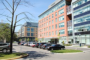
The Centre for Addiction and Mental Health (CAMH, pronounced KAM-aytch, French: Centre de toxicomanie et de santé mentale) is a psychiatric teaching hospital located in Toronto and ten community locations throughout the province of Ontario, Canada. It reports being the largest research facility in Canada for mental health and addictions. The hospital was formed in 1998 from the amalgamation of four separate institutions – the Queen Street Mental Health Centre, the Clarke Institute of Psychiatry, the Addiction Research Foundation, and the Donwood Institute.

Niagara, Toronto
Neighbourhood in Toronto, Ontario, Canada
Distance: Approx. 352 meters
Latitude and longitude: 43.643,-79.408
Niagara is a neighbourhood in Toronto, Ontario, Canada, located south of Queen Street West; it is usually bordered by Strachan Avenue to the west, Bathurst Street to the east, and the railway corridor to the south, and so named because Niagara Street runs through the centre of it. The eastern portion of this area (with what is now called the Fashion District) was first planned as the New Town Extension when Toronto was incorporated as a city. The area was developed as a residential area for the workers of industries located along the CN and CP railway corridors.

Grand Prix of Toronto
Annual car race in Canada
Distance: Approx. 590 meters
Latitude and longitude: 43.63722222,-79.41555556
The Ontario Honda Dealers Indy Toronto is an annual Indy Car race, held in Toronto, Ontario, Canada. Originally known as the Molson Indy Toronto, it was part of the Champ Car World Series from 1986 to 2007. After a one-year hiatus, it has been part of the NTT IndyCar Series schedule since 2009.

Queen's York Rangers (1st American Regiment)
Military unit
Distance: Approx. 647 meters
Latitude and longitude: 43.6369,-79.408
The Queen's York Rangers (1st American Regiment) (RCAC) is a Canadian Army Primary Reserve Royal Canadian Armoured Corps regiment based in Toronto and Aurora. The regiment is part of 4th Canadian Division's 32 Canadian Brigade Group. The regiment consists of one cavalry squadron (D Squadron), as well as the Headquarters and Training Squadron.

Toronto Central Prison
Men's prison
Distance: Approx. 397 meters
Latitude and longitude: 43.638789,-79.414503
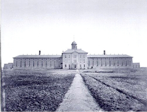
The Toronto Central Prison, also known as the Central Prison, Central Prison for Men, and more colloquially as The Toronto Jail (the third of four Toronto area jails to be given that nickname) was a prison in Toronto, Ontario, Canada. It was a 336-bed facility located near the intersection of King Street and Strachan Avenue. It opened in 1873, when the area was still well away from any residential development.

2005 Molson Indy Toronto
Motor car race
Distance: Approx. 590 meters
Latitude and longitude: 43.63722222,-79.41555556
The 2005 Molson Indy Toronto was the sixth round of the 2005 Bridgestone Presents the Champ Car World Series Powered by Ford season, held on July 10, 2005 on the streets of Exhibition Place in Toronto, Ontario, Canada. Sébastien Bourdais was the pole sitter and Justin Wilson won the race. It was the first American open wheel victory for the British driver.

2004 Molson Indy Toronto
Motor car race
Distance: Approx. 590 meters
Latitude and longitude: 43.63722222,-79.41555556
The 2004 Molson Indy Toronto was the sixth round of the 2004 Bridgestone Presents the Champ Car World Series Powered by Ford season, held on July 11, 2004 on the streets of Exhibition Place in Toronto, Ontario, Canada. Sébastien Bourdais swept the pole and the race win, his third consecutive win and fourth overall for the season. In doing so he also took over the lead in the drivers championship standings, a lead which he would not relinquish for the remainder of the season.
Trinity-Bellwoods
Neighbourhood in Toronto, Ontario, Canada
Distance: Approx. 611 meters
Latitude and longitude: 43.64666667,-79.40833333
Trinity-Bellwoods is an inner city neighbourhood in Toronto, Ontario, Canada. It is bounded on the east by Bathurst Street, on the north by College Street, on the south by Queen Street West, and by Dovercourt Road on the west. It has a large Portuguese (mostly originally from the Azores and Madeira islands) and Brazilian community, and many local Portuguese-Canadian businesses are located along Dundas Street West, continuing west into Little Portugal; this stretch further west along Dundas is known as Rua Açores.
Toronto Central Prison Chapel
Distance: Approx. 398 meters
Latitude and longitude: 43.63875,-79.41444444
The Toronto Central Prison Chapel is an 1877 former Roman Catholic prison chapel, located in Toronto, Ontario, Canada. The building is the last remaining building of the Toronto Central Prison complex which was located south of King Street and west of Strachan Avenue in Toronto. The other remaining portion of the prison is a wall of the prison's paint shop on the east side of the Liberty Storage Warehouse.

Massey Harris Lofts
Heritage building in Toronto, Canada
Distance: Approx. 79 meters
Latitude and longitude: 43.64154,-79.412939
The Massey Harris Lofts is a loft condominium in the Liberty Village area of downtown Toronto, Ontario, Canada. The building is the former head office of Massey-Harris Limited, later known as Massey Ferguson, a large agricultural implements manufacturer. It is the last building remaining from a large factory complex that Massey-Harris operated on King Street West from the 1870s until the 1980s.

Garrison Crossing
Bridge in Ontario, Canada
Distance: Approx. 479 meters
Latitude and longitude: 43.638928,-79.407793
The Garrison Crossing (formerly named Fort York Pedestrian and Cycle Bridge), located in downtown Toronto, provides a link between Stanley Park in the north and the Garrison Common of the Fort York grounds in the south. The crossing includes two stainless steel bridges over rail corridors. The bridges form an important pedestrian and cyclist link to the Waterfront that also connects three parks - Ordnance Park, South Stanley Park with the Fort York neighbourhood.
Edulis (restaurant)
Restaurant in Toronto, Ontario, Canada
Distance: Approx. 444 meters
Latitude and longitude: 43.64194444,-79.40658333
Edulis is a restaurant in Toronto, Ontario, Canada. The restaurant serves European and Mediterranean cuisine, and has received a Michelin star. Tobey Nemeth is the chef and co-owner.
Weather in this IP's area
overcast clouds
-8 Celsius
-15 Celsius
-9 Celsius
-7 Celsius
1019 hPa
67 %
1019 hPa
1006 hPa
10000 meters
5.14 m/s
280 degree
100 %

