Country:
 USA
USARegion:
City:
Latitude and Longitude:
Time Zone:
Postal Code:
IP information under different IP Channel
ip-api
Country
Region
City
ASN
Time Zone
ISP
Blacklist
Proxy
Latitude
Longitude
Postal
Route
IPinfo
Country
Region
City
ASN
Time Zone
ISP
Blacklist
Proxy
Latitude
Longitude
Postal
Route
MaxMind
Country
Region
City
ASN
Time Zone
ISP
Blacklist
Proxy
Latitude
Longitude
Postal
Route
Luminati
Country
USRegion
tx
City
roundrock
ASN
Time Zone
America/Chicago
ISP
TEXASNET-ASN
Latitude
Longitude
Postal
db-ip
Country
Region
City
ASN
Time Zone
ISP
Blacklist
Proxy
Latitude
Longitude
Postal
Route
ipdata
Country
Region
City
ASN
Time Zone
ISP
Blacklist
Proxy
Latitude
Longitude
Postal
Route
Popular places and events near this IP address

Round Rock, Texas
City in Texas, United States
Distance: Approx. 1372 meters
Latitude and longitude: 30.52694444,-97.66388889
Round Rock is a city in the U.S. state of Texas, in Williamson County (with a small part in Travis County), which is a part of the Greater Austin metropolitan area. Its population is 119,468 according to the 2020 census. The city straddles the Balcones Escarpment, a fault line in which the areas roughly east of Interstate 35 are flat and characterized by having black, fertile soils of the Blackland Prairie, and the west side of the Escarpment, which consists mostly of hilly, karst-like terrain with little topsoil and higher elevations and which is part of the Texas Hill Country.

Round Rock High School
High school in the United States
Distance: Approx. 2647 meters
Latitude and longitude: 30.509218,-97.695553
Round Rock High School is a public high school located in Round Rock, Texas, a suburb of North Austin. Founded in 1867, it is the oldest high school in the Round Rock Independent School District. As of 2021, it is the largest high school in the Greater Austin area by student enrollment.

Stony Point High School
Public school in Round Rock, Texas, United States
Distance: Approx. 1783 meters
Latitude and longitude: 30.53014,-97.66162
Stony Point High School is a high school in the Round Rock Independent School District (RRISD) in Round Rock, Texas, United States.

Round Rock Public Library
Library in Round Rock, Texas, U.S.
Distance: Approx. 1039 meters
Latitude and longitude: 30.5102,-97.6779
Round Rock Public Library (RRPL) is a public library located in Round Rock, Texas
Round Rock Christian Academy
Private christian school in Round Rock, Texas, United States
Distance: Approx. 2480 meters
Latitude and longitude: 30.509211,-97.693736
Round Rock Christian Academy is a private Christian PK-12th grade school in Round Rock, Texas, United States.

Round Rock Multipurpose Complex
Sports complex in Texas
Distance: Approx. 1243 meters
Latitude and longitude: 30.5083,-97.6789
Round Rock Multipurpose Complex is a multi-sports complex in Round Rock, Texas, United States and was the home of the Austin Elite of Major League Rugby. It was established in 2017 and serves people being a multi-sports complex in various sports like soccer, football, basketball. skill development training, one-on-one training, backyard sports, etc.
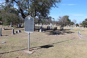
Round Rock Cemetery
Cemetery in Round Rock, Texas, U.S.
Distance: Approx. 2620 meters
Latitude and longitude: 30.5175,-97.69611111
Round Rock Cemetery is a cemetery in Round Rock, Williamson County, Texas, United States.

Koughan Memorial Water Tower Park
Park and water tower in Round Rock, Texas, U.S.
Distance: Approx. 1259 meters
Latitude and longitude: 30.50884,-97.6796
Koughan Memorial Water Tower Park is a park with a water tower in Round Rock, Texas, United States.
Immortal Ten Bridge
Bridge in Round Rock, Texas, U.S.
Distance: Approx. 1311 meters
Latitude and longitude: 30.506693,-97.678102
The Immortal Ten Bridge is a bridge in Round Rock, Texas, United States built at the intersection of Mays St and the railroad in response to the January 22, 1927 crash of a passenger train into a bus carrying the Baylor University basketball team headed to a game at The University of Texas, which killed 10 of the 22 passengers. The accident spurred the use of overpasses to improve safety with the bridge being the first railroad overpass in Texas. Union Pacific donated $100,000 (equivalent to $2,220,000 in 2023) toward the bridge, completed in 1935.

Chisholm Trail Crossing Park
Park in Round Rock, Texas, U.S.
Distance: Approx. 2004 meters
Latitude and longitude: 30.5119,-97.6894
Chisholm Trail Crossing Park, or simply Chisholm Trail Park, is a park in Round Rock, Texas, United States. The park was dedicated in 2003. Texas artist Jim Thomas has been commissioned to complete a series of bronze sculptures for the park, including one depicting a resting longhorn as well as The Pioneer Woman, The Pioneer Boy, The Bell Steer, and Goin' to Water.
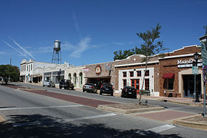
Round Rock Commercial Historic District
Historic district in Round Rock, Texas, U.S.
Distance: Approx. 1142 meters
Latitude and longitude: 30.5083,-97.6775
The Round Rock Commercial Historic District is an historic district in Round Rock, Texas, listed on the National Register of Historic Places.

Prete Main Street Plaza
Public square in Round Rock, Texas, U.S.
Distance: Approx. 1099 meters
Latitude and longitude: 30.50861111,-97.67722222
Sharon Prete Main Street Plaza (also known as Main Street Plaza, Prete Main Street Plaza, and Prete Plaza) is a public square with a fountain in Round Rock, Texas, United States. The plaza hosts the city-sponsored Music on Main concert series. Dale Watson was featured in 2021, following a break in the series because of the COVID-19 pandemic.
Weather in this IP's area
scattered clouds
33 Celsius
34 Celsius
32 Celsius
35 Celsius
1014 hPa
43 %
1014 hPa
990 hPa
10000 meters
4.63 m/s
70 degree
40 %
07:26:45
19:10:50