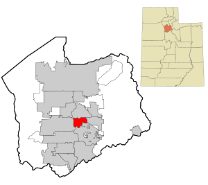
Country:
 USA
USARegion:
City:
Latitude and Longitude:
Time Zone:
Postal Code:
IP information under different IP Channel
ip-api
Country
Region
City
ASN
Time Zone
ISP
Blacklist
Proxy
Latitude
Longitude
Postal
Route
IPinfo
Country
Region
City
ASN
Time Zone
ISP
Blacklist
Proxy
Latitude
Longitude
Postal
Route
MaxMind
Country
Region
City
ASN
Time Zone
ISP
Blacklist
Proxy
Latitude
Longitude
Postal
Route
Luminati
Country
USRegion
tx
City
pflugerville
ASN
Time Zone
America/Chicago
ISP
TEXASNET-ASN
Latitude
Longitude
Postal
db-ip
Country
Region
City
ASN
Time Zone
ISP
Blacklist
Proxy
Latitude
Longitude
Postal
Route
ipdata
Country
Region
City
ASN
Time Zone
ISP
Blacklist
Proxy
Latitude
Longitude
Postal
Route
Popular places and events near this IP address
Little Cottonwood Creek Valley, Utah
CDP in Utah, United States
Distance: Approx. 2756 meters
Latitude and longitude: 40.60138889,-111.825
Little Cottonwood Creek Valley was a census-designated place (CDP) in Salt Lake County, Utah. The 2000 Census population was 7,221, an increase over the 1990 figure of 5,042. In 2005, the CDP became part of the newly incorporated city of Cottonwood Heights.
Midvale, Utah
City in Utah, United States
Distance: Approx. 2834 meters
Latitude and longitude: 40.61388889,-111.88833333
Midvale City is located in the heart of Salt Lake County, Utah, United States. It is part of the Salt Lake City metropolitan area. Midvale's population was 34,124 according to 2019 estimates from the U.S. Census Bureau.
Brighton High School (Cottonwood Heights, Utah)
School in Cottonwood Heights, Utah, United States
Distance: Approx. 2374 meters
Latitude and longitude: 40.61222222,-111.82694444
Brighton High School in Cottonwood Heights, Utah is located about ten miles (16 km) south of Salt Lake City. It serves students in grades 9-12 for the Canyons School District.

Henry J. Wheeler Farm
United States historic place
Distance: Approx. 2629 meters
Latitude and longitude: 40.63416667,-111.86166667
The Henry J. Wheeler Farm is a farmstead in Murray, Utah, United States, that is one of the few remaining late 19th century farmsteads in the Salt Lake Valley that has not been lost to expanding housing developments of metropolitan Salt Lake City. It has been listed on the National Register of Historic Places since 1976.
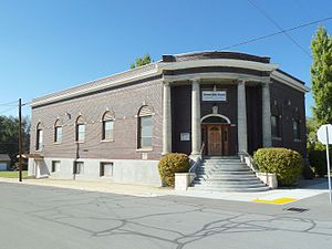
Sandy Second Ward Chapel
United States historic place
Distance: Approx. 2686 meters
Latitude and longitude: 40.59472222,-111.87833333
The Sandy Second Ward Chapel (formerly known as the Berean Baptist Church and the Anchor Baptist Church) is a location in Sandy, Utah listed on the National Register of Historic Places. It was designed by the architect Don Carlos Young, a son of Brigham Young. It was later sold by the Church of Jesus Christ of Latter-day Saints.

Fort Union (Utah)
Commercial area in Utah, United States
Distance: Approx. 1448 meters
Latitude and longitude: 40.62,-111.8675
Fort Union, historically Union, is a major commercial area and an early settlement in the Salt Lake Valley of Utah that is now split between the municipalities of Midvale, Cottonwood Heights, and Sandy. The fort after which the area was named was built early (1853) in the Salt Lake Valley's post-1847 history at a strategic point where escarpments on either side of the Little Cottonwood Creek valley create a narrow gateway to the upper valley and Little Cottonwood Canyon beyond. The effects of geography on travel through the area have also contributed to the area's much more recent success as a retail and employment destination.

Jordan and Salt Lake City Canal
Distance: Approx. 2483 meters
Latitude and longitude: 40.62638889,-111.87638889
The Jordan and Salt Lake City Canal is a 28-mile (45 km) historic waterway in Salt Lake County, Utah, United States.

East Jordan Canal
Distance: Approx. 1464 meters
Latitude and longitude: 40.6160589,-111.8710456
The East Jordan Canal is a historic waterway in Salt Lake County, Utah, United States.
FanX
Comic-book convention in Salt Lake City
Distance: Approx. 2610 meters
Latitude and longitude: 40.60217,-111.88354983
FanX Salt Lake (formerly Salt Lake Comic Con) is an annual multi-genre pop culture expo held in Salt Lake City, Utah, United States. It is produced by Dan Farr and Bryan Brandenburg under Dan Farr Productions and is Utah's most attended convention according to the Governor's Office of Economic Development. The first convention took place at the Salt Palace Convention Center in Salt Lake City.
St. James Episcopal Church (Midvale, Utah)
Parish in the Episcopal Diocese of Utah
Distance: Approx. 606 meters
Latitude and longitude: 40.615,-111.86
St. James Episcopal Church, named for James the Greater, is a parish in the Episcopal Diocese of Utah of the Episcopal Church located in Midvale, Utah.
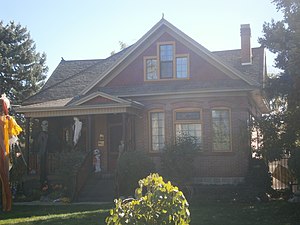
Emma Olive Dobbs House
Historic house in Utah, United States
Distance: Approx. 2650 meters
Latitude and longitude: 40.59194444,-111.87361111
The Emma Olive Dobbs House, at 578 E. Locust St. in Sandy, Utah, was built in the years around 1905–10. It was listed on the National Register of Historic Places in 1996.
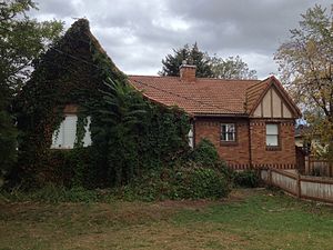
Brady-Brady House
United States historic place
Distance: Approx. 1471 meters
Latitude and longitude: 40.59888889,-111.86166667
The Brady-Brady House, at 8395 South 1000 East in Sandy, Utah, was built in 1930. It was listed on the National Register of Historic Places in 2004. The listing included two contributing buildings.
Weather in this IP's area
clear sky
25 Celsius
24 Celsius
24 Celsius
27 Celsius
1019 hPa
24 %
1019 hPa
872 hPa
10000 meters
5.14 m/s
360 degree
07:28:23
19:02:39