Country:
 USA
USARegion:
City:
Latitude and Longitude:
Time Zone:
Postal Code:
IP information under different IP Channel
ip-api
Country
Region
City
ASN
Time Zone
ISP
Blacklist
Proxy
Latitude
Longitude
Postal
Route
IPinfo
Country
Region
City
ASN
Time Zone
ISP
Blacklist
Proxy
Latitude
Longitude
Postal
Route
MaxMind
Country
Region
City
ASN
Time Zone
ISP
Blacklist
Proxy
Latitude
Longitude
Postal
Route
Luminati
Country
USRegion
tx
City
pflugerville
ASN
Time Zone
America/Chicago
ISP
TEXASNET-ASN
Latitude
Longitude
Postal
db-ip
Country
Region
City
ASN
Time Zone
ISP
Blacklist
Proxy
Latitude
Longitude
Postal
Route
ipdata
Country
Region
City
ASN
Time Zone
ISP
Blacklist
Proxy
Latitude
Longitude
Postal
Route
Popular places and events near this IP address

Austin–Bergstrom International Airport
Civilian airport serving Austin, Texas, United States
Distance: Approx. 4217 meters
Latitude and longitude: 30.19444444,-97.67
Austin–Bergstrom International Airport, or ABIA (IATA: AUS, ICAO: KAUS, FAA LID: AUS, formerly BSM), is an international airport in Austin, Texas, United States, serving the Greater Austin metropolitan area. Located about 5 miles (8 km; 4 nmi) southeast of downtown Austin, it covers 4,242 acres (1,717 ha) and has two runways and three helipads. The airport lies on the site of what was Bergstrom Air Force Base, named after Captain John August Earl Bergstrom, an officer who was the first person from Austin to be killed in World War II. The base was decommissioned in the early 1990s, and the land reverted to the city, which used it to replace Robert Mueller Municipal Airport as Austin's main airport in 1999.
Ushicon
Distance: Approx. 4097 meters
Latitude and longitude: 30.22305556,-97.74583333
Ushicon is an annual three day anime convention held during February at the Wyndham Garden Austin in Austin, Texas. The convention resumed operation in 2011 as an 18-and-older event. It was originally held in Austin, Texas, from 2002 to 2006 until ceasing operations due to changes in anime fandom and facility issues.
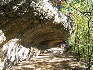
Smith Rock Shelter
United States historic place
Distance: Approx. 1932 meters
Latitude and longitude: 30.1842,-97.7238
The Smith Rock Shelter is a natural limestone overhang in McKinney Falls State Park near Austin, Texas. The shelter is believed to have been used by Native Americans from 500 BCE until the 18th century. The last known occupants were related to the Tonkawa.

McKinney Falls State Park
State park in Texas, United States
Distance: Approx. 2190 meters
Latitude and longitude: 30.18083333,-97.72194444
McKinney Falls State Park is a state park in Austin, Texas, United States at the confluence of Onion Creek and Williamson Creek. It is administered by the Texas Parks and Wildlife Department. The park opened on April 15, 1976 and is named after Thomas F. McKinney, a businessman, race horse breeder and rancher, who owned and lived on the land in the mid-to-late 19th century.

McKinney Homestead
Historic house in Texas, United States
Distance: Approx. 1245 meters
Latitude and longitude: 30.18972222,-97.72055556
The McKinney Homestead is a former limestone home built between 1850 and 1852 by Thomas F. McKinney, owner of the surrounding land. The two-story homestead was continuously occupied until it burned in the 1940s. Archaeological investigations in 1974 determined the house was built with limestone quarried from Onion Creek.

Pilot Knob (Austin, Texas)
Eroded core of an extinct volcano located 8 miles (13 km) south of central Austin, Texas
Distance: Approx. 4166 meters
Latitude and longitude: 30.16222222,-97.70611111
Pilot Knob is the eroded core of an extinct volcano located in Austin, Texas, United States. It is near Austin–Bergstrom International Airport and McKinney Falls State Park.
Williamson Creek Greenbelt
Park and greenbelt located in Austin, Texas
Distance: Approx. 4293 meters
Latitude and longitude: 30.1879,-97.7562
Williamson Creek Greenbelt is a park and greenbelt located in the south of Austin, Texas, running along Williamson Creek and its tributaries.
East Riverside-Oltorf, Austin, Texas
Distance: Approx. 3871 meters
Latitude and longitude: 30.23333333,-97.72055556
East Riverside-Oltorf is a neighborhood in Austin, Texas, located southeast of the city's urban core. The East Riverside, Parker Lane, and Pleasant Valley neighborhoods together form the East Riverside-Oltorf Combined Neighborhood Planning Area. The region is bounded on the north by Lake Lady Bird, to the east by Grove Boulevard and the Montopolis neighborhood, Texas State Highway 71 to the south, and Interstate 35 and South River City to the west.
National Black Deaf Advocates
U.S. non-profit organization
Distance: Approx. 3696 meters
Latitude and longitude: 30.217048,-97.7458165
The National Black Deaf Advocates (NBDA) is an advocacy organization for Black deaf and hard of hearing people in the United States.

Montopolis, Austin, Texas
Neighborhood in Austin, Texas, United States
Distance: Approx. 3651 meters
Latitude and longitude: 30.22861111,-97.69694444
Travis County has had two locations named Montopolis. The first was during the Republic of Texas period north of the Colorado River. The second is today's Montopolis neighborhood in Austin, Texas south of the river.
Austin ReBlend
Paint recycling program
Distance: Approx. 2788 meters
Latitude and longitude: 30.21346,-97.73724
Austin ReBlend is a paint recycling program administered by the City of Austin in Austin, Texas. In 2012, Austin ReBlend produced 12,767 US gal (48,330 L) of wholly recycled paint.
Travis Association for the Blind
Distance: Approx. 3063 meters
Latitude and longitude: 30.2129642,-97.7410068
Travis Association for the Blind, also known as the Austin Lighthouse, is a 501(c)(3) non-profit organization employing over 400 Texans of which approximately 200 are legally blind in four facilities in southeast Austin, Texas, as well as a facility in Taylor, Texas. Travis Association for the Blind warehouses, distributes, manufactures, and repairs a wide variety of merchandise for local, state, and federal government as well as private industry. The mission of the Austin Lighthouse is to enhance the opportunities for the economic and personal independence of people who are blind or visually impaired by creating, sustaining, and improving employment.
Weather in this IP's area
clear sky
33 Celsius
35 Celsius
32 Celsius
35 Celsius
1013 hPa
45 %
1013 hPa
994 hPa
10000 meters
1.79 m/s
4.02 m/s
315 degree
2 %
07:26:47
19:11:09