207.2.82.126 - IP Lookup: Free IP Address Lookup, Postal Code Lookup, IP Location Lookup, IP ASN, Public IP
Country:
Region:
City:
Location:
Time Zone:
Postal Code:
IP information under different IP Channel
ip-api
Country
Region
City
ASN
Time Zone
ISP
Blacklist
Proxy
Latitude
Longitude
Postal
Route
Luminati
Country
Region
mn
City
rogers
ASN
Time Zone
America/Chicago
ISP
C1-BGP
Latitude
Longitude
Postal
IPinfo
Country
Region
City
ASN
Time Zone
ISP
Blacklist
Proxy
Latitude
Longitude
Postal
Route
IP2Location
207.2.82.126Country
Region
minnesota
City
eagan
Time Zone
America/Chicago
ISP
Language
User-Agent
Latitude
Longitude
Postal
db-ip
Country
Region
City
ASN
Time Zone
ISP
Blacklist
Proxy
Latitude
Longitude
Postal
Route
ipdata
Country
Region
City
ASN
Time Zone
ISP
Blacklist
Proxy
Latitude
Longitude
Postal
Route
Popular places and events near this IP address

Brown College (Minnesota)
For-profit career college with campuses in Minnesota
Distance: Approx. 2229 meters
Latitude and longitude: 44.865,-93.16333333
Brown College was a private for-profit college in Mendota Heights, Minnesota. It merged with another college in March 2014, to form Sanford-Brown College. These campuses were part of a larger group of schools under the same general heading.
Saint Thomas Academy
Private military high school in Mendota Heights, Minnesota, United States
Distance: Approx. 2488 meters
Latitude and longitude: 44.86805556,-93.13722222
Saint Thomas Academy (abbr. STA), originally known as St. Thomas Aquinas Seminary and formerly known as St.
Visitation School
Private school in Mendota Heights, , Minnesota, United States
Distance: Approx. 2710 meters
Latitude and longitude: 44.86861111,-93.1325
Visitation School, also known as Visitation or Vis, is an independent, all-girls, Roman Catholic, college-preparatory, school in Minnesota. It is located in Mendota Heights near Saint Paul. Visitation is a coeducational school for grades Montessori PreK-grade 5, and all-girls for grades 6–12.
Big Rivers Regional Trail
Distance: Approx. 2914 meters
Latitude and longitude: 44.86722222,-93.17388889
Big Rivers Regional Trail is a paved 4.5-mile (7.2 km) rail trail that overlooks the confluence of the Minnesota and Mississippi rivers along the northern edge of Dakota County, Minnesota, United States. It runs between the cities of Eagan and Lilydale. The trail also links to the 72-mile (116 km) Mississippi National River and Recreation Area, hundreds of miles of trails throughout the greater Minneapolis–Saint Paul metropolitan area, and historic landmarks including Fort Snelling, Pike Island and the city of Mendota, one of Minnesota's oldest settlements.
Cereals & Grains Association
U.S. non-profit professional organization
Distance: Approx. 1877 meters
Latitude and longitude: 44.83555556,-93.16638889
Cereals & Grains Association (formerly AACC International, formerly the American Association of Cereal Chemists) is a non-profit professional organization of members who are specialists in the use of cereal grains in foods. Founded in 1916, they are headquartered in Eagan, Minnesota.

Eagan Transit Station
Distance: Approx. 2170 meters
Latitude and longitude: 44.83222222,-93.16666667
The Eagan Transit Station is a transit facility located in Eagan, Minnesota. Riders also hail from the nearby communities of Mendota Heights and Northern Rosemount. The Park & Ride lot has 750 parking spaces for bus passengers and retail employees.
Le Cordon Bleu College of Culinary Arts Minneapolis/St. Paul
Distance: Approx. 2257 meters
Latitude and longitude: 44.86638889,-93.16
Le Cordon Bleu College of Culinary Arts Minneapolis/Saint Paul was founded in 1999. The college is owned by Career Education Corporation under a licensing agreement with Le Cordon Bleu in Paris. It closed in 2017 along with all other Le Cordon Bleu colleges in the United States in the wake of changing federal loan guidelines.

Dakota County Library
Regional public library system in Dakota County, Minnesota
Distance: Approx. 3482 meters
Latitude and longitude: 44.81777778,-93.16333333
Dakota County Library is a public library in Dakota County, Minnesota, headquartered in the Wescott Library in Eagan. The system includes 10 locations.
Augusta Lake (Dakota County, Minnesota)
Lake in the state of Minnesota, United States
Distance: Approx. 3450 meters
Latitude and longitude: 44.87805556,-93.15694444
Augusta Lake is a lake in Dakota County, in the U.S. state of Minnesota. Augusta Lake was named for a daughter of Henry Hastings Sibley.
Rogers Lake (Minnesota)
Lake in the state of Minnesota, United States
Distance: Approx. 2777 meters
Latitude and longitude: 44.87138889,-93.13944444
Rogers Lake is a lake in Dakota County, in the U.S. state of Minnesota. Rogers Lake was named for E. G. Rogers, a pioneer farmer who settled there. Wagon Wheel Trail divides the two sections of the lake (the northern is sometimes referred to as "Mendakota Lake") which are connected by a culvert (a popular fishing spot).
St. Thomas Ice Arena
Ice hockey arena in Mendota Heights, Minnesota
Distance: Approx. 2131 meters
Latitude and longitude: 44.86453,-93.13726
St. Thomas Ice Arena is a 1,000-seat ice hockey arena in Mendota Heights, Minnesota. Opened in 2003, it is home to the University of St.

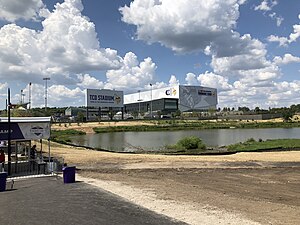
Twin Cities Orthopedics Performance Center
Minnesota Vikings headquarters, including a 6,000-seat outdoor stadium
Distance: Approx. 3024 meters
Latitude and longitude: 44.8613,-93.1166
Twin Cities Orthopedics Performance Center (commonly referred to as TCO Performance Center) is a 40-acre sports complex located in Eagan, Minnesota. Its main use is as the Minnesota Vikings' headquarters and practice facility. The facility includes a 6,000-seat outdoor stadium known as TCO Stadium, in addition to a fully-enclosed indoor practice field and several outdoor natural and synthetic turf practice fields.
Weather in this IP's area
clear sky
-12 Celsius
-19 Celsius
-13 Celsius
-11 Celsius
1031 hPa
54 %
1031 hPa
996 hPa
10000 meters
4.63 m/s
330 degree
