Country:
 USA
USARegion:
City:
Latitude and Longitude:
Time Zone:
Postal Code:
IP information under different IP Channel
ip-api
Country
Region
City
ASN
Time Zone
ISP
Blacklist
Proxy
Latitude
Longitude
Postal
Route
IPinfo
Country
Region
City
ASN
Time Zone
ISP
Blacklist
Proxy
Latitude
Longitude
Postal
Route
MaxMind
Country
Region
City
ASN
Time Zone
ISP
Blacklist
Proxy
Latitude
Longitude
Postal
Route
Luminati
Country
USRegion
ia
City
iowacity
ASN
Time Zone
America/Chicago
ISP
IMONC
Latitude
Longitude
Postal
db-ip
Country
Region
City
ASN
Time Zone
ISP
Blacklist
Proxy
Latitude
Longitude
Postal
Route
ipdata
Country
Region
City
ASN
Time Zone
ISP
Blacklist
Proxy
Latitude
Longitude
Postal
Route
Popular places and events near this IP address
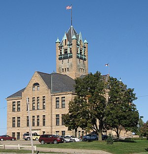
Johnson County, Iowa
County in Iowa, United States
Distance: Approx. 3178 meters
Latitude and longitude: 41.66666667,-91.58333333
Johnson County is located in the U.S. state of Iowa. As of the 2020 census, the population was 152,854, making it the fourth-most populous county in Iowa. The county seat is Iowa City, home of the University of Iowa.

Coralville, Iowa
City in Iowa, United States
Distance: Approx. 880 meters
Latitude and longitude: 41.68833333,-91.58666667
Coralville is a city in Johnson County, Iowa, United States. It is a suburb of Iowa City and part of the Iowa City Metropolitan Statistical Area. The population was 22,318 at the 2020 census.
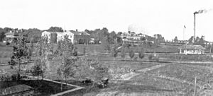
Oakdale, Iowa
Unincorporated community in Iowa, United States
Distance: Approx. 1565 meters
Latitude and longitude: 41.70638889,-91.60305556
Oakdale was an unincorporated rural residential village established in 1908 by the State of Iowa as a statewide treatment center for tuberculosis (TB) in rural Johnson County, located about five miles northwest of central Iowa City and now a part of Coralville, immediately adjacent to the community of North Liberty. The site was chosen for its remoteness, its location along a railroad, and its proximity to University of Iowa Hospitals and Clinics in Iowa City. As a partially self-sustaining community, Oakdale included a depot on the Cedar Rapids and Iowa City Railway (CRandIC) line, power plant, several residential patient and staff buildings, pharmacy, postal and administrative units, as well as associated facilities to support varied farming operations intended to help sustain the institution, including a large dairy.
Iowa Medical and Classification Center
Distance: Approx. 2493 meters
Latitude and longitude: 41.713,-91.61
The Iowa Medical and Classification Center (IMCC) is a medium security correctional facility located in the Johnson County community Oakdale in Coralville, Iowa. It currently houses about 900 inmates. The main role of the IMCC is to serve as a reception and classification center for adults being sent to prison.
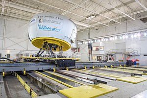
University of Iowa Driving Safety Research Institute
Distance: Approx. 1678 meters
Latitude and longitude: 41.708,-91.6017
The Driving Safety Research Institute (DSRI) at the University of Iowa College of Engineering houses the National Advanced Driving Simulator (NADS-1) and a fleet of instrumented on-road research vehicles. The NADS-1 is one of the largest ground vehicle driving simulators in the world. The National Highway Traffic Safety Administration (NHTSA) owns the NADS-1 simulator, while the University of Iowa takes responsibility for operation and maintenance.
AnimeIowa
Anime convention in Coralville, Iowa
Distance: Approx. 3239 meters
Latitude and longitude: 41.68180556,-91.55858333
AnimeIowa is an annual three-day anime convention held during July at the Hyatt Regency Coralville Hotel & Conference Center in Coralville, Iowa. The staff are all volunteers and the convention is run by the non-profit Mindbridge Foundation.

Edgewater Park Site
Late Archaic period Indian archaeological site in Iowa
Distance: Approx. 3350 meters
Latitude and longitude: 41.682,-91.557
The Edgewater Park Site is a 3,800-year-old Late Archaic campsite situated along the Iowa River in Coralville, Iowa, United States. Plant remains recovered from the site suggest the inhabitants were in the earliest stages of adapting domesticated plants. Excavations revealed a small encampment of two hearths and areas for faunal and stone tool production.
Clear Creek (Iowa River tributary)
Stream in Johnson and Iowa County, Iowa, U.S.
Distance: Approx. 3716 meters
Latitude and longitude: 41.670016,-91.562947
Clear Creek is a stream in Johnson and Iowa counties, Iowa, in the United States. It is a tributary of Iowa River. The name of Clear Creek originally referred to the clarity of its waters, which have since become muddied with the advent of intensive agriculture in the area.
Coralville Union Ecclesiastical Church
United States historic place
Distance: Approx. 2954 meters
Latitude and longitude: 41.67422222,-91.57036111
Coralville Union Ecclesiastical Church, also known as Coralville Town Hall, is a historic building located in Coralville, Iowa, United States. It was listed on the National Register of Historic Places in 1977.

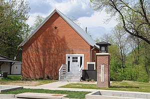
Coralville Public School
United States historic place
Distance: Approx. 3002 meters
Latitude and longitude: 41.67366667,-91.57033333
Coralville Public School, also known as the Fifth Street School, is a historic building located in Coralville, Iowa, United States. This two-story brick structure replaced Coralville's first school building, which was destroyed in a fire. It housed grades one through eight from 1876 to 1949, and it was the town's only school building during that time.
Xtream Arena
Multipurpose arena in Coralville, Iowa
Distance: Approx. 2971 meters
Latitude and longitude: 41.68136111,-91.5625
Xtream Arena powered by Mediacom is a multipurpose arena in Coralville, Iowa, that opened in September 2020.
Muddy Creek (Iowa River tributary)
Stream in Iowa, U.S.
Distance: Approx. 3696 meters
Latitude and longitude: 41.69472222,-91.54944444
Muddy Creek is a stream in the U.S. state of Iowa. It is a tributary to the Iowa River. Muddy Creek was so named due to the muddy character of its waters.
Weather in this IP's area
clear sky
31 Celsius
32 Celsius
30 Celsius
32 Celsius
1010 hPa
48 %
1010 hPa
986 hPa
10000 meters
7.2 m/s
10.29 m/s
180 degree
06:51:15
19:08:49