207.164.247.46 - IP Lookup: Free IP Address Lookup, Postal Code Lookup, IP Location Lookup, IP ASN, Public IP
Country:
 Canada
Region:
City:
Location:
Time Zone:
Postal Code:
ISP:
ASN:
language:
User-Agent:
Proxy IP:
Blacklist:
IP information under different IP Channel
ip-api
Country
Region
City
ASN
Time Zone
ISP
Blacklist
Proxy
Latitude
Longitude
Postal
Route
db-ip
Country
Region
City
ASN
Time Zone
ISP
Blacklist
Proxy
Latitude
Longitude
Postal
Route
IPinfo
Country
Region
City
ASN
Time Zone
ISP
Blacklist
Proxy
Latitude
Longitude
Postal
Route
IP2Location
207.164.247.46Country
caRegion
quebec
City
sainte-madeleine
Time Zone
America/Montreal
ISP
Language
User-Agent
Latitude
Longitude
Postal
ipdata
Country
Region
City
ASN
Time Zone
ISP
Blacklist
Proxy
Latitude
Longitude
Postal
Route
Popular places and events near this IP address

La Vallée-du-Richelieu Regional County Municipality
Regional county municipality in Quebec, Canada
Distance: Approx. 8629 meters
Latitude and longitude: 45.56666667,-73.2
La Vallée-du-Richelieu (French pronunciation: [la vale dy ʁiʃ(ə)ljø], The Valley of the Richelieu) is a regional county municipality in the Montérégie region in southwestern Quebec, Canada. Its seat is McMasterville. It surrounds the Richelieu River as the river flows north from Lake Champlain in the United States to the Saint Lawrence River northeast of Montreal at Sorel-Tracy, Quebec.

Beloeil, Quebec
City in Quebec, Canada
Distance: Approx. 8629 meters
Latitude and longitude: 45.56666667,-73.2
Beloeil (; French pronunciation: [bɛlœj]) is a city in Quebec, Canada. It is a suburb of Montreal, on the South Shore and is on the Richelieu River, 32 kilometres (20 mi) east of Montreal. According to the official Commission de toponymie du Québec, the name is written Belœil with an oe ligature; however, other sources avoid the ligature, including the Ministry of Municipal Affairs and the town's own official website.

Mont-Saint-Hilaire
City in Quebec, Canada
Distance: Approx. 8288 meters
Latitude and longitude: 45.56222222,-73.19166667
Mont-Saint-Hilaire (French pronunciation: [mɔ̃ sɛ̃t‿ilɛʁ]) is a suburb of Montreal on the South Shore of southeastern Quebec, Canada, on the Richelieu River in the Regional County Municipality of La Vallée-du-Richelieu. The population as of the Canada 2021 Census was 18,859. The city is named after the Mont Saint-Hilaire.

Mont Saint-Hilaire
Mountain in Montérégie, Quebec, Canada
Distance: Approx. 6631 meters
Latitude and longitude: 45.55222222,-73.15083333
Mont Saint-Hilaire (French pronunciation: [mɔ̃ sɛ̃t‿ilɛʁ]; English: Mount Saint-Hilaire; Western Abnaki: Wigwômadenek, Wigwômadensizek;, Western Abnaki: Wigwômaden; see § Names of Mont Saint-Hilaire for other names) is a mountain, 414 m (1,358 ft) high, in the Montérégie region of southern Quebec. It is about thirty kilometres east of Montreal, and immediately east of the Richelieu River. It is one of the Monteregian Hills.
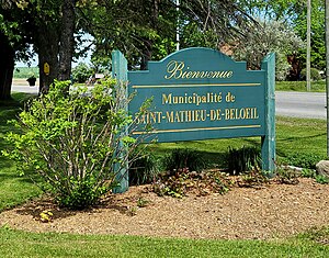
Saint-Mathieu-de-Beloeil
Municipality in Quebec, Canada
Distance: Approx. 8629 meters
Latitude and longitude: 45.56666667,-73.2
Saint-Mathieu-de-Beloeil (French pronunciation: [sɛ̃ matjø də bɛlœj]) is a municipality in southwestern Quebec, Canada, east of Montreal in the Regional County Municipality of La Vallée-du-Richelieu. The population as of the 2021 Canadian Census was 2,952.

Sainte-Marie-Madeleine, Quebec
Parish municipality in Quebec, Canada
Distance: Approx. 0 meters
Latitude and longitude: 45.6,-73.1
Sainte-Marie-Madeleine (French pronunciation: [sɛ̃t maʁi madlɛn]) is a parish municipality in southwestern Quebec, Canada, in Les Maskoutains Regional County Municipality. The population as of the Canada 2021 Census was 2,876.

Sainte-Madeleine, Quebec
Village municipality in Quebec, Canada
Distance: Approx. 0 meters
Latitude and longitude: 45.6,-73.1
Sainte-Madeleine (French pronunciation: [sɛ̃t madlɛn]) is a village municipality in southwestern Quebec, Canada in Les Maskoutains Regional County Municipality. The population as of the Canada 2011 Census was 2,356. Le Camping Ste-Madeleine, founded in 1967 for visitors to EXPO 67, is the area's principal tourist attraction.

La Présentation
Municipality in Quebec, Canada
Distance: Approx. 8380 meters
Latitude and longitude: 45.66666667,-73.05
La Présentation (French pronunciation: [la pʁezɑ̃tasjɔ̃]) is a municipality in southern Quebec, Canada on the Salvail River in Les Maskoutains Regional County Municipality. The population as of the Canada 2011 Census was 2,466.

Saint-Hyacinthe Aerodrome
Aerodrome in Saint-Hyacinthe, Quebec, Canada
Distance: Approx. 6661 meters
Latitude and longitude: 45.60666667,-73.015
Saint-Hyacinthe Aerodrome (TC LID: CSU3) is located 3 nautical miles (5.6 km; 3.5 mi) west of Saint-Hyacinthe, Quebec, Canada. The Saint-Hyacinthe Aerodrome is an example of general aviation diversity driven by private management. Almost all airplanes on floats land on its man-made water basin, parallel to the runway.

Borduas
Provincial electoral district in Quebec, Canada
Distance: Approx. 7097 meters
Latitude and longitude: 45.648,-73.16
Borduas is a provincial electoral district in the Montérégie region of Quebec, Canada that elects members to the National Assembly of Quebec. It notably includes the municipality of Beloeil, Mont-Saint-Hilaire and Otterburn Park. It was created for the 1994 election from Verchères and Iberville.

Mont-Saint-Hilaire station
Railway station in Quebec, Canada
Distance: Approx. 6628 meters
Latitude and longitude: 45.57722222,-73.17861111
Mont-Saint-Hilaire station (French pronunciation: [mɔ̃ sɛ̃t‿ilɛʁ]) is a commuter rail station operated by Exo in Mont-Saint-Hilaire, Quebec, Canada. It is the eastern terminus of the Mont-Saint-Hilaire line.
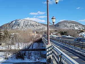
Jordi-Bonet Bridge
Bridge on Richelieu River, Quebec, Canada
Distance: Approx. 8806 meters
Latitude and longitude: 45.56388889,-73.20055556
The Jordi-Bonet Bridge (French: pont Jordi-Bonet) is a road bridge linking Beloeil and Mont-Saint-Hilaire and spanning the Richelieu River, in La Vallée-du-Richelieu Regional County Municipality, in Montérégie, Québec, Canada. This bridge mainly serves residents of the Beloeil-Mont-Saint-Hilaire region, as well as traffic connecting Saint-Bruno to Saint-Hyacinthe, along Sir-Wilfrid-Laurier Boulevard. The bridge serves as a crossing for Quebec Route 116 and 229.
Weather in this IP's area
clear sky
-17 Celsius
-24 Celsius
-17 Celsius
-15 Celsius
1026 hPa
64 %
1026 hPa
1022 hPa
10000 meters
4.02 m/s
5.81 m/s
311 degree
4 %