Country:
 Puerto Rico
Region:
City:
Latitude and Longitude:
Time Zone:
Postal Code:
IP information under different IP Channel
ip-api
Country
Region
City
ASN
Time Zone
ISP
Blacklist
Proxy
Latitude
Longitude
Postal
Route
IPinfo
Country
Region
City
ASN
Time Zone
ISP
Blacklist
Proxy
Latitude
Longitude
Postal
Route
MaxMind
Country
Region
City
ASN
Time Zone
ISP
Blacklist
Proxy
Latitude
Longitude
Postal
Route
Luminati
Country
PRCity
sabanaseca
ASN
Time Zone
America/Puerto_Rico
ISP
NUSTREAM-COMMUNICATIONS
Latitude
Longitude
Postal
db-ip
Country
Region
City
ASN
Time Zone
ISP
Blacklist
Proxy
Latitude
Longitude
Postal
Route
ipdata
Country
Region
City
ASN
Time Zone
ISP
Blacklist
Proxy
Latitude
Longitude
Postal
Route
Popular places and events near this IP address

Luis Muñoz Rivera Park
Park in San Juan, Puerto Rico
Distance: Approx. 687 meters
Latitude and longitude: 18.46416667,-66.09055556
The Luis Muñoz Rivera Park (or Parque Luis Muñoz Rivera in Spanish) is a 27.2 acre (110,000 m2) recreational public space located in Puerta de Tierra in San Juan, Puerto Rico. The park was named in honor of Puerto Rican statesman Luis Muñoz Rivera. It is the largest public square in the San Juan metropolitan area.

Puerta de Tierra, San Juan
Subbarrio of San Juan Antiguo in Puerto Rico
Distance: Approx. 377 meters
Latitude and longitude: 18.46166667,-66.09638889
Puerta de Tierra is a subbarrio (subdistrict) occupying the eastern portion of the Islet of San Juan and the barrio of San Juan Antiguo in the municipality of San Juan, Puerto Rico. The name Puerta de Tierra (Spanish for land gate) derives from the former eastern gated entrance to the walled city of San Juan where Plaza Colón (formerly Santiago Square, named after the Puerta de Santiago) is today. With a population of 2,924 as of 2010, this is the most populated area of San Juan Antiguo.

Casa Rosa
Historic house in Old San Juan, Puerto Rico
Distance: Approx. 724 meters
Latitude and longitude: 18.46805556,-66.10305556
Casa Rosa or Casa Rosada, also known as the Pink House, is a historic house located in Old San Juan, Puerto Rico. The house was built in 1812 as a barrack for the troops assigned to the San Agustin Bastion. It was converted to an officers quarters in 1881 by the Spanish Army.

School of Tropical Medicine (Puerto Rico)
Historic place in San Juan, Puerto Rico
Distance: Approx. 773 meters
Latitude and longitude: 18.467003,-66.104005
The School of Tropical Medicine (Spanish: Escuela de Medicina Tropical), was an educational institution created in 1926 by an act of the Puerto Rican Legislature, to further the research initiated by the Anemia Commissions and the Institute of Tropical Medicine on anemia and its causes. The institution existed as an independent entity until 1949, when it was integrated into the School of Medicine of the University of Puerto Rico.

Puerto Rico National Library
Library in San Juan, Puerto Rico
Distance: Approx. 514 meters
Latitude and longitude: 18.4638,-66.0923
The Puerto Rico National Library (Spanish: Biblioteca Nacional de Puerto Rico) is the national library of Puerto Rico. It was created in 1967 as the Biblioteca General de Puerto Rico (Puerto Rico General Library) by Joint Resolution No. 44 of the Puerto Rico Legislature.
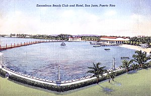
El Escambrón Beach
Beach in Puerto Rico
Distance: Approx. 770 meters
Latitude and longitude: 18.46694444,-66.09
El Escambrón Beach (Spanish: Balneario del Escambrón) is a public-access beach located in the San Juan Antiguo sub-district (subbarrio) of Puerta de Tierra, next to the Luis Muñoz Rivera Park in San Juan, Puerto Rico. The beach and recreational complex are located on the grounds of the former Escambrón Beach Club and Hotel which featured a large swimming pool enclosed by breakwaters. Although the pool no longer exists, the beach is still enclosed by a series of coral reefs and other natural breakwaters, such as the Peñón de San Jorge reef, making it popular for swimmers and families.

El Falansterio de Puerta de Tierra
Historic place in San Juan, Puerto Rico
Distance: Approx. 196 meters
Latitude and longitude: 18.46333333,-66.09638889
The Puerta de Tierra Phalanstery (Spanish: Falansterio de Puerta de Tierra), simply known as El Falansterio and originally known as the Puerta de Tierra Tenement Group Project A, is a historic district and Art Deco public housing building complex from 1937 located in the Puerta de Tierra sub-district of San Juan, Puerto Rico. The district is located in the eastern section of the Islet of San Juan, close to the Capitol of Puerto Rico, and it is bounded by the Manuel Fernández Juncos Avenue to the south, San Juan Bautista Street to the east, and the del Tren and Matías Ledesma Streets to the north and west, respectively. The construction was a New Deal investment from the Puerto Rico Reconstruction Administration with funding from the Federal Emergency Relief Administration.

Church, School, Convent and Parish House of San Agustín
United States historic place
Distance: Approx. 195 meters
Latitude and longitude: 18.4656953,-66.0986962
The Church, School, Convent and Parish House of San Agustín is a National Register of Historic Places (NRHP)-listed historic religious complex located in the Puerta de Tierra historic district of San Juan Antiguo in the city of San Juan, Puerto Rico. The complex consists of the Church of St. Augustine (Spanish: Iglesia de San Agustín), its adjacent Augustinian convent (also housing the Catholic school) and the parish house.

Escuela Brambaugh
United States historic place
Distance: Approx. 106 meters
Latitude and longitude: 18.4654155,-66.0960993
Brambaugh School (Spanish: Escuela Brambaugh), officially the Dr. Martin Grove Brumbaugh School but better known today as Puerta de Tierra Public School (Escuela Pública de Puerta de Tierra), is an early 20th-century historic school building located in the Puerta de Tierra historic district in the city of San Juan, Puerto Rico. The school was built in 1913 by Frank B. Hatch based on designs by architect G.R. Gilmour and named after the first Education Commissioner of Puerto Rico Martin Grove Brumbaugh.

José Celso Barbosa Graded School
United States historic place
Distance: Approx. 466 meters
Latitude and longitude: 18.4659954,-66.101282
The José Celso Barbosa Graded School (Spanish: Escuela Graduada José Celso Barbosa) is a historic school building located in the Puerta de Tierra historic district in the city of San Juan, Puerto Rico. The school is named after Puerto Rico statehood movement founder Dr. José Celso Barbosa and has been listed in the National Register of Historic Places since 1989, and on the Puerto Rico Register of Historic Sites and Zones since 2000.

Templo del Maestro
United States historic place
Distance: Approx. 777 meters
Latitude and longitude: 18.4628977,-66.0899807
Templo del Maestro (Spanish for 'Temple of the Teacher') is a historic Beaux Arts building from 1937 that originally served as the seat of the Puerto Rico Teachers Association (Spanish: Asociación de Maestros de Puerto Rico). The building faces the Luis Muñoz Rivera Park and Supreme Court Building across Juan Ponce de León Avenue in the Puerta de Tierra historic district, a sequence of historically and culturally significant buildings and monuments that includes the Puerto Rico National Library, the Athenaeum and El Capitolio.

Arsenal de San Juan
Historic site in San Juan, Puerto Rico
Distance: Approx. 508 meters
Latitude and longitude: 18.46611111,-66.10166667
The former Spanish Navy Arsenal of San Juan (Spanish: Arsenal de la Marina Española), historically known as the San Juan Naval Station and also known as the Navy Arsenal of La Puntilla (Arsenal de la Marina de la Puntilla), the Arsenal of San Juan (Arsenal de San Juan) or simply El Arsenal, is a historic building complex and former Spanish Navy armory located in La Puntilla, a former neighborhood of the Old San Juan historic district in San Juan, Puerto Rico. It was built in 1800 at the site of the old main port of San Juan, today the Old San Juan marine and cruise piers area between the former United States Custom House and the Coast Guard Station.
Weather in this IP's area
light rain
27 Celsius
30 Celsius
25 Celsius
29 Celsius
1011 hPa
91 %
1011 hPa
1011 hPa
10000 meters
1.72 m/s
2.11 m/s
97 degree
38 %
06:12:54
18:23:14