Country:
 USA
USARegion:
City:
Latitude and Longitude:
Time Zone:
Postal Code:
IP information under different IP Channel
ip-api
Country
Region
City
ASN
Time Zone
ISP
Blacklist
Proxy
Latitude
Longitude
Postal
Route
IPinfo
Country
Region
City
ASN
Time Zone
ISP
Blacklist
Proxy
Latitude
Longitude
Postal
Route
MaxMind
Country
Region
City
ASN
Time Zone
ISP
Blacklist
Proxy
Latitude
Longitude
Postal
Route
Luminati
Country
USASN
Time Zone
America/Chicago
ISP
TVC-AS1
Latitude
Longitude
Postal
db-ip
Country
Region
City
ASN
Time Zone
ISP
Blacklist
Proxy
Latitude
Longitude
Postal
Route
ipdata
Country
Region
City
ASN
Time Zone
ISP
Blacklist
Proxy
Latitude
Longitude
Postal
Route
Popular places and events near this IP address

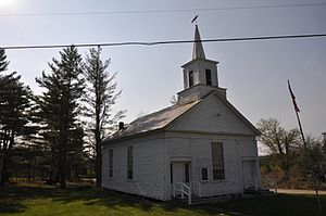
Marlboro College
Private coeducational liberal arts college in Marlboro, Vermont
Distance: Approx. 40 meters
Latitude and longitude: 42.83916667,-72.73527778
Marlboro College was a private college in Marlboro, Vermont. Founded in 1946, it remained intentionally small, operating as a self-governing community with students following self-designed degree plans culminating in a thesis. In 1998, the college added a graduate school.
Halifax, Vermont
Town in Vermont, United States
Distance: Approx. 6474 meters
Latitude and longitude: 42.78194444,-72.74944444
Halifax is a town in Windham County, Vermont, in the United States. As of the 2020 census, the town population was 771.
Jacksonville, Vermont
Village in Vermont, United States
Distance: Approx. 8505 meters
Latitude and longitude: 42.79694444,-72.82166667
Jacksonville is a village in the town of Whitingham, Windham County, Vermont, United States. The population was 213 at the 2020 census.

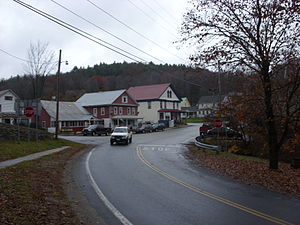
Marlboro, Vermont
Town in Vermont, United States
Distance: Approx. 2675 meters
Latitude and longitude: 42.86305556,-72.73222222
Marlboro is a town in Windham County, Vermont, United States. The population was 1,722 at the 2020 census. The town is home to both the Southern Vermont Natural History Museum and Potash Hill, the campus that was formerly Marlboro College.

Marlboro Music School and Festival
Music training program in Marlboro, Vermont, United States since 1951
Distance: Approx. 210 meters
Latitude and longitude: 42.839049,-72.732234
The Marlboro Music School and Festival is a retreat for advanced classical training and musicianship held for seven weeks each summer in Marlboro, Vermont, in the United States. Public performances are held each weekend while the school is in session, with the programs chosen only a week or so in advance from the sixty to eighty works being currently rehearsed. Marlboro Music was conceived as a retreat where young musicians could collaborate and learn alongside master artists in an environment removed from the pressures of performance deadlines or recording.
Windham-2 Vermont Representative District, 2002–2012
Distance: Approx. 7135 meters
Latitude and longitude: 42.81666667,-72.81666667
The Windham-2 Representative District is a one-member state Representative district in the U.S. state of Vermont. It is one of the 108 one or two member districts into which the state was divided by the redistricting and reapportionment plan developed by the Vermont General Assembly following the 2000 U.S. Census. The plan applies to legislatures elected in 2002, 2004, 2006, 2008, and 2010.
Marlboro School
Distance: Approx. 3508 meters
Latitude and longitude: 42.86861111,-72.71972222
The Marlboro School is a small public school in Marlboro, Vermont. Marlboro is a member of the Coalition of Essential Schools Marlboro has an enrollment of 79 students. It is one of six k-8 schools in Vermont with an enrollment of less than 80.
WRSY
Radio station in Marlboro, Vermont
Distance: Approx. 3917 meters
Latitude and longitude: 42.84611111,-72.68777778
WRSY (101.5 MHz) is a commercial FM radio station licensed to Marlboro, Vermont. The station is owned by Saga Communications, and operates as part of its Monadnock Broadcasting Group. WRSY airs an adult album alternative radio format, via a simulcast of 93.9 WRSI in Turners Falls, Massachusetts.
Hogback Mountain (Vermont)
Mountain in Vermont, United States
Distance: Approx. 5301 meters
Latitude and longitude: 42.86694444,-72.7875
Hogback Mountain is a mountain in southern Vermont, United States, in the town of Marlboro, Vermont, just north of Vermont Route 9. Its main peak is 2,409 feet (734 m) high. The area is well known for expansive views from Route 9.

Southern Vermont Natural History Museum
Distance: Approx. 3406 meters
Latitude and longitude: 42.861049,-72.763871
The Southern Vermont Natural History Museum is a natural history museum, at the Hogback Mountain Scenic Overlook on Route 9 in West Marlboro, Vermont. The museum is surrounded by the Hogback Mountain Conservation Area, over 600 acres of protected forest land, with views of three states. The Museum was established in 1996 around the Luman Ranger Nelson Natural History Collection, one of the largest collections of native birds and mammals in the northeast, with 250 species represented.

Molly Stark State Park
State park in Bennington County, Vermont, United States
Distance: Approx. 6258 meters
Latitude and longitude: 42.8508,-72.8098
Molly Stark State Park is a 148-acre state park in Wilmington, Vermont. The park is named for Molly Stark, the famous wife of General John Stark of the American Revolutionary War, and is located along the Molly Stark Byway. Activities includes camping, hiking, picnicking, mountain biking, wildlife watching, and winter sports.

West Halifax, Vermont
Village in Vermont, United States
Distance: Approx. 6471 meters
Latitude and longitude: 42.78722222,-72.77055556
West Halifax is an unincorporated village in the town of Halifax, Windham County, Vermont, United States. The community is 2.7 miles (4.3 km) east-southeast of Jacksonville. West Halifax has a post office with ZIP code 05358.
Weather in this IP's area
broken clouds
10 Celsius
10 Celsius
9 Celsius
11 Celsius
1010 hPa
95 %
1010 hPa
954 hPa
10000 meters
0.45 m/s
4.47 m/s
145 degree
70 %
06:23:45
19:13:31