Country:
 USA
USARegion:
City:
Latitude and Longitude:
Time Zone:
Postal Code:
IP information under different IP Channel
ip-api
Country
Region
City
ASN
Time Zone
ISP
Blacklist
Proxy
Latitude
Longitude
Postal
Route
IPinfo
Country
Region
City
ASN
Time Zone
ISP
Blacklist
Proxy
Latitude
Longitude
Postal
Route
MaxMind
Country
Region
City
ASN
Time Zone
ISP
Blacklist
Proxy
Latitude
Longitude
Postal
Route
Luminati
Country
USASN
Time Zone
America/Chicago
ISP
SEABORN
Latitude
Longitude
Postal
db-ip
Country
Region
City
ASN
Time Zone
ISP
Blacklist
Proxy
Latitude
Longitude
Postal
Route
ipdata
Country
Region
City
ASN
Time Zone
ISP
Blacklist
Proxy
Latitude
Longitude
Postal
Route
Popular places and events near this IP address

Beverly, Massachusetts
City in the United States
Distance: Approx. 811 meters
Latitude and longitude: 42.558,-70.88
Beverly is a city in Essex County, Massachusetts, United States, and a suburb of Boston. The population was 42,670 at the time of the 2020 United States Census. A resort, residential, and manufacturing community on the Massachusetts North Shore, Beverly includes Ryal Side, North Beverly, Montserrat, Beverly Farms and Prides Crossing.

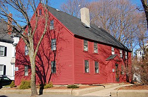
John Balch House
Historic house in Massachusetts, United States
Distance: Approx. 352 meters
Latitude and longitude: 42.56222222,-70.88438889
The John Balch House, located at 448 Cabot Street, Beverly, Massachusetts, is one of the oldest wood-frame houses in the United States. It is now operated as one of the historic house museums of Historic Beverly, and open seasonally.

Beverly School for the Deaf
School in Beverly, Massachusetts, United States
Distance: Approx. 652 meters
Latitude and longitude: 42.55638889,-70.89222222
The Children's Center for Communication/Beverly School for the Deaf (CCCBSD) is a school, established in 1876, for students from birth to age twenty-two who are Deaf, Hard-of-Hearing, or hearing with complex communication needs by providing language that is visually accessible via American Sign Language, written English, speech, and AAC/Assistive Technology.
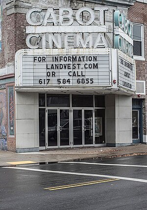
Cabot Street Cinema Theatre
Theatre in Massachusetts, US
Distance: Approx. 1393 meters
Latitude and longitude: 42.55139444,-70.878775
The Cabot Performing Arts Center is located at 286 Cabot Street in Beverly, Massachusetts.

United Shoe Machinery Corporation Clubhouse
United States historic place
Distance: Approx. 632 meters
Latitude and longitude: 42.56444444,-70.89527778
The United Shoe Machinery Corporation Clubhouse is a historic clubhouse at 134 McKay Street in Beverly, Massachusetts. The building is now known as Beverly Golf and Tennis Clubhouse. The English Revival building was designed by Boston architect Henry Bailey Alden, and built in 1910 as a gift from the senior management of the United Shoe Machinery Corporation to its local employees.
Hazadiah Smith House
Historic house in Massachusetts, United States
Distance: Approx. 1143 meters
Latitude and longitude: 42.55444444,-70.87861111
The Hazadiah Smith House is a historic First Period house in Beverly, Massachusetts. The 2.5-story wood-frame house was built c. 1686, probably by Hazadiah Smith, whose profession is frequently listed in contemporary records as a builder or housewright.
Beverly Cotton Manufactory
Historic cotton mill in Beverly, Massachusetts, US
Distance: Approx. 1286 meters
Latitude and longitude: 42.57264444,-70.89318333
Beverly Cotton Manufactory was the first cotton mill built in America, and the largest cotton mill to be built during its era. It was built hoping for economic success, but reached a downturn due to technical limitations of the then early production process and limitations of the machines being used. Being the birthplace and testing grounds of the cotton milling industry at the time, it has been called the birthplace of the American Industrial Revolution.
Northshore Academy, Beverly
Alternative high school in Beverly, Massachusetts, United States
Distance: Approx. 1153 meters
Latitude and longitude: 42.5693,-70.8792
Northshore Academy Upper School is a public alternative high school in Beverly, Massachusetts, United States, serving students in grades 7–12. It is a school for the specials.

Beverly High School
Public high school in Beverly, Massachusetts, United States
Distance: Approx. 691 meters
Latitude and longitude: 42.56444444,-70.88111111
Beverly High School is one of two four-year public high schools in Beverly, Massachusetts, United States, the other being the smaller Northshore Academy. It has an enrollment of approximately 1,300 students and is accredited by the Massachusetts Department of Education and by the New England Association of Schools and Colleges. The staff consists of a Principal, three assistant principals, an Athletic Director, six Guidance Counselors and about a hundred teachers including six department heads.

Shore Country Day School
Private elementary and middle school in US
Distance: Approx. 792 meters
Latitude and longitude: 42.5687,-70.888
Shore Country Day School is an independent elementary and middle school, founded in 1936 following the tenets of the Country Day School movement. The private school educates students in grade levels ranging from a Pre-Kindergarten program through to Grade 9. It is accredited by the Association of Independent Schools of New England (AISNE) with the most recent accreditation review in 2008.

Beverly Powder House
United States historic place
Distance: Approx. 1428 meters
Latitude and longitude: 42.55333333,-70.87527778
The Beverly Powder House is a historic military storage magazine on Powder House Lane in Beverly, Massachusetts. Built in 1809, this small brick building housed the community's military supplies during the War of 1812, and is one of a few such structures to survive in the state. It is the town's only surviving Federal-period municipal structure.
Beverly rooming house fire
1984 arson attack in Beverly, Massachusetts
Distance: Approx. 954 meters
Latitude and longitude: 42.55472222,-70.88166667
The Beverly rooming house fire took place at the Elliott Chambers, a low-rent rooming house in Beverly, Massachusetts, on July 4, 1984. Prosecutors alleged that the fire was set by a man whose ex-girlfriend dated someone who lived in the building, eventually convicting James Carver of second-degree murder and arson. It was the deadliest arson fire in Massachusetts, the deadliest fire in the state since the Cocoanut Grove fire in 1942, and the deadliest fire in Beverly's history.
Weather in this IP's area
overcast clouds
17 Celsius
17 Celsius
15 Celsius
18 Celsius
1009 hPa
84 %
1009 hPa
1008 hPa
10000 meters
4.47 m/s
8.94 m/s
302 degree
100 %
06:15:31
19:07:41