207.113.185.118 - IP Lookup: Free IP Address Lookup, Postal Code Lookup, IP Location Lookup, IP ASN, Public IP
Country:
Region:
City:
Location:
Time Zone:
Postal Code:
IP information under different IP Channel
ip-api
Country
Region
City
ASN
Time Zone
ISP
Blacklist
Proxy
Latitude
Longitude
Postal
Route
Luminati
Country
Region
in
City
plymouth
ASN
Time Zone
America/Indiana/Indianapolis
ISP
SURFAIRWIRELESS-IN-02
Latitude
Longitude
Postal
IPinfo
Country
Region
City
ASN
Time Zone
ISP
Blacklist
Proxy
Latitude
Longitude
Postal
Route
IP2Location
207.113.185.118Country
Region
indiana
City
plymouth
Time Zone
America/Indiana/Indianapolis
ISP
Language
User-Agent
Latitude
Longitude
Postal
db-ip
Country
Region
City
ASN
Time Zone
ISP
Blacklist
Proxy
Latitude
Longitude
Postal
Route
ipdata
Country
Region
City
ASN
Time Zone
ISP
Blacklist
Proxy
Latitude
Longitude
Postal
Route
Popular places and events near this IP address
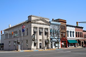
Plymouth, Indiana
City in Indiana, United States
Distance: Approx. 235 meters
Latitude and longitude: 41.34388889,-86.3125
Plymouth is a city and the county seat of Marshall County, Indiana, United States. The population is 10,214 in the 2020 census. Plymouth was the site of the first retail outlet of defunct U.S. retailer Montgomery Ward in 1926.
WTCA
Radio station in Indiana, United States
Distance: Approx. 2822 meters
Latitude and longitude: 41.31837778,-86.31139444
WTCA (1050 AM) is a radio station broadcasting a hot adult contemporary format. Licensed to Plymouth, Indiana, United States, the station is owned by Kathy and Jim Bottorff, through licensee Community Service Broadcasters, Inc.

Hoham-Klinghammer-Weckerle House and Brewery Site
Historic house in Indiana, United States
Distance: Approx. 1834 meters
Latitude and longitude: 41.33541667,-86.32866667
The Hoham-Klinghammer-Weckerle House and Brewery Site, located in Plymouth, Marshall County, Indiana is connected to three German families, all related through marriage, that settled in the area in 1844–1865. The Hoham, Klinghammer, and Weckerle families established and operated the Plymouth Brewery from 1857 to 1888. Among several buildings that existed at brewery site was a Stick/Queen Anne style house, now the only remaining building at the site.
Plymouth Municipal Airport (Indiana)
Airport
Distance: Approx. 2498 meters
Latitude and longitude: 41.365,-86.30027778
Plymouth Municipal Airport (IATA: PLY, FAA LID: C65) is a public use airport located two nautical miles (4 km) north of the central business district of Plymouth, a city in Marshall County, Indiana, United States. It is owned by the Plymouth Board of Aviation of Commissioners. This airport is included in the National Plan of Integrated Airport Systems for 2011–2015, which categorized it as a general aviation facility.
Plymouth High School (Indiana)
Public high school in Plymouth, Marshall County, Indiana, United States
Distance: Approx. 715 meters
Latitude and longitude: 41.347405,-86.302708
Plymouth High School is a public high school located in Plymouth, Indiana, United States.
Plymouth Downtown Historic District
Historic district in Indiana, United States
Distance: Approx. 320 meters
Latitude and longitude: 41.34083333,-86.30944444
Plymouth Downtown Historic District is a national historic district located in Plymouth, Marshall County, Indiana, United States. The district encompasses 47 contributing buildings and one contributing structure in the central business district of Plymouth. It developed between about 1870 and 1940, and includes examples of Italianate, Romanesque Revival, and Colonial Revival style architecture.

Plymouth Northside Historic District
Historic district in Indiana, United States
Distance: Approx. 187 meters
Latitude and longitude: 41.345,-86.31111111
Plymouth Northside Historic District is a national historic district located at Plymouth, Marshall County, Indiana. The district encompasses 141 contributing buildings, 2 contributing sites, 6 contributing structures, and 3 contributing objects in a predominantly residential section of Plymouth. It developed between about 1870 and 1940, and includes examples of Italianate, Gothic Revival, Queen Anne, Colonial Revival, Tudor Revival, Neoclassical, and Renaissance Revival style architecture.

Plymouth Southside Historic District
Historic district in Indiana, United States
Distance: Approx. 187 meters
Latitude and longitude: 41.345,-86.31111111
Plymouth Southside Historic District is a national historic district located at Plymouth, Marshall County, Indiana. The district encompasses 91 contributing buildings, 2 contributing structures, and 1 contributing object in a predominantly residential section of Plymouth. It developed between about 1853 and 1953, and includes examples of Italianate, Greek Revival, Queen Anne, Colonial Revival, and Tudor Revival style architecture.

Marshall County Courthouse (Indiana)
United States historic place
Distance: Approx. 118 meters
Latitude and longitude: 41.34361111,-86.31111111
Marshall County Courthouse is a historic courthouse located at Plymouth, Marshall County, Indiana. It was built between 1870 and 1872, and is a two-story, brick and limestone building in a combination of Italianate and Renaissance Revival styles. It is rectangular in form and has a hipped roof with central bell tower.: 2 It was listed in the National Register of Historic Places in 1983.
Plymouth Fire Station
United States historic place
Distance: Approx. 262 meters
Latitude and longitude: 41.34138889,-86.31027778
Plymouth Fire Station is a historic fire station located at Plymouth, Marshall County, Indiana. It was built in 1875, and is a two-story, painted brick building with a 59-foot tall bell tower. It features round-arched pedestrian entrances and bays, parapet with tile coping, and a round window in the bell tower.: 2 It was listed on the National Register of Historic Places in 1981.

Heminger Travel Lodge
United States historic place
Distance: Approx. 834 meters
Latitude and longitude: 41.34361111,-86.29972222
Heminger Travel Lodge is a historic hotel located on the Lincoln Highway at Plymouth, Marshall County, Indiana. It was built in 1937, and is a two-story, Colonial Revival style brown brick building with a red clay tile gable roof. Attached to the building is a one-story "sun porch" with a hipped roof.: 5 It was listed on the National Register of Historic Places in 2000.

East LaPorte Street Footbridge
United States historic place
Distance: Approx. 599 meters
Latitude and longitude: 41.34027778,-86.30416667
East LaPorte Street Footbridge is a historic footbridge located at Plymouth, Marshall County, Indiana. It was built in 1898 by the Rochester Bridge Company and spans the Yellow River. It is a two-span, Kingpost truss bridge measuring 100 feet long and 6 feet wide.
Weather in this IP's area
overcast clouds
-3 Celsius
-8 Celsius
-3 Celsius
-2 Celsius
1022 hPa
78 %
1022 hPa
992 hPa
10000 meters
5.14 m/s
10.29 m/s
250 degree
100 %


