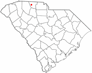
Country:
 USA
USARegion:
City:
Latitude and Longitude:
Time Zone:
Postal Code:
IP information under different IP Channel
ip-api
Country
Region
City
ASN
Time Zone
ISP
Blacklist
Proxy
Latitude
Longitude
Postal
Route
IPinfo
Country
Region
City
ASN
Time Zone
ISP
Blacklist
Proxy
Latitude
Longitude
Postal
Route
MaxMind
Country
Region
City
ASN
Time Zone
ISP
Blacklist
Proxy
Latitude
Longitude
Postal
Route
Luminati
Country
USRegion
sc
City
cowpens
ASN
Time Zone
America/New_York
ISP
ROCK-HILL-TELEPHONE
Latitude
Longitude
Postal
db-ip
Country
Region
City
ASN
Time Zone
ISP
Blacklist
Proxy
Latitude
Longitude
Postal
Route
ipdata
Country
Region
City
ASN
Time Zone
ISP
Blacklist
Proxy
Latitude
Longitude
Postal
Route
Popular places and events near this IP address

Cowpens, South Carolina
Town in South Carolina, United States
Distance: Approx. 2975 meters
Latitude and longitude: 35.01611111,-81.80416667
Cowpens is a town in Spartanburg County, South Carolina, United States. The population was 2,162 at the 2010 census. The town was chartered February 20, 1880, and was incorporated in 1900.

Mayo, South Carolina
CDP in South Carolina, United States
Distance: Approx. 6116 meters
Latitude and longitude: 35.08805556,-81.85111111
Mayo is a census-designated place (CDP) in Spartanburg County, South Carolina, United States. The population was 1,592 at the 2010 census.
WYFG
Radio station in Gaffney, South Carolina
Distance: Approx. 9143 meters
Latitude and longitude: 35.116,-81.778
WYFG (91.1 FM) is a radio station simulcasting the Bible Broadcasting Network for the Gaffney, Spartanburg, and Greenville areas of South Carolina as well as some of the western suburbs of the Charlotte area. The transmitter is located off South Carolina Highway 11 atop Thicketty Mountain (which is about 5 miles east of Chesnee).
Thicketty, South Carolina
Unincorporated community in South Carolina, United States
Distance: Approx. 8873 meters
Latitude and longitude: 35.01638889,-81.72472222
Thicketty (also spelled Thickety) is an unincorporated community in Cherokee County, South Carolina, United States. It lies between Gaffney and Cowpens along U.S. Route 29. Thicketty is located approximately 12 miles (19 km) northeast of Spartanburg.
Lake Blalock
Reservoir in South Carolina, United States
Distance: Approx. 6756 meters
Latitude and longitude: 35.075,-81.8785
Lake Blalock (formally, the H. Taylor Blalock Reservoir) is a reservoir in Spartanburg County, South Carolina, located on the Pacolet River about five miles north of Spartanburg. After its creation was authorized in 1976 by the Commissioners of Spartanburg Water System, Blalock Dam was constructed in 1983. The existing earthen dam is approximately 700 ft (210 m).

Spartanburg High School
Public school in Spartanburg, South Carolina, United States
Distance: Approx. 8850 meters
Latitude and longitude: 34.97942,-81.879639
Spartanburg High School is a public high school in Spartanburg, South Carolina, United States. It is part of Spartanburg County School District 7. The current principal is Andrew McMillan, former principal of Chapman High School in Inman, South Carolina.
Cherokee Springs, South Carolina
Unincorporated community in South Carolina, US
Distance: Approx. 6762 meters
Latitude and longitude: 35.04972222,-81.89083333
Cherokee Springs is an unincorporated community in Spartanburg County, in the U.S. state of South Carolina.
Clifton, South Carolina
CDP in South Carolina, United States
Distance: Approx. 6060 meters
Latitude and longitude: 34.98611111,-81.82027778
Clifton is a Census-designated place located in Spartanburg County in the U.S. State of South Carolina. According to the 2010 United States Census, the population was 541.
Converse, South Carolina
CDP in South Carolina, United States
Distance: Approx. 5519 meters
Latitude and longitude: 34.99555556,-81.84305556
Converse is a Census-designated place located in Spartanburg County in the U.S. State of South Carolina. According to the 2010 United States Census, the population was 608.

Cowpens Depot
United States historic place
Distance: Approx. 3084 meters
Latitude and longitude: 35.01555556,-81.80277778
Cowpens Depot, also known as Cowpens Depot Museum and Civic Center, is a historic train station located at Cowpens, Spartanburg County, South Carolina. It was built in 1896 by the Southern Railway. It is a one-story, rectangular frame building painted gray, with a gable roof and freight loading platform.

Converse Mill
United States historic place
Distance: Approx. 5479 meters
Latitude and longitude: 34.99416667,-81.83777778
The Converse Mill, also known as Clifton Mill #3, is a historic textile mill at 200 High Street in Spartanburg, South Carolina. The main mill building is a four-story brick building with smaller additions, sited on 11 acres (4.5 ha) overlooking the Pacolet River to the east. The mill was built in 1903 on the site of Clifton Mill #3, then the largest textile mill in the world, which had been destroyed by flood.
Broome High School
Public high school in Spartanburg County, South Carolina
Distance: Approx. 6460 meters
Latitude and longitude: 34.986111,-81.842222
Gettys D. Broome High School is a public high school in Spartanburg, South Carolina, United States. A part of Spartanburg County School District 3, it was constructed in 1975 after the consolidation of multiple other high schools in the surrounding area. It has a student population of approximately 900.
Weather in this IP's area
clear sky
20 Celsius
19 Celsius
18 Celsius
22 Celsius
1020 hPa
42 %
1020 hPa
990 hPa
10000 meters
07:30:07
18:57:17