Country:
 USA
USARegion:
City:
Latitude and Longitude:
Time Zone:
Postal Code:
IP information under different IP Channel
ip-api
Country
Region
City
ASN
Time Zone
ISP
Blacklist
Proxy
Latitude
Longitude
Postal
Route
IPinfo
Country
Region
City
ASN
Time Zone
ISP
Blacklist
Proxy
Latitude
Longitude
Postal
Route
MaxMind
Country
Region
City
ASN
Time Zone
ISP
Blacklist
Proxy
Latitude
Longitude
Postal
Route
Luminati
Country
USRegion
or
City
portland
ASN
Time Zone
America/Los_Angeles
ISP
STERLING
Latitude
Longitude
Postal
db-ip
Country
Region
City
ASN
Time Zone
ISP
Blacklist
Proxy
Latitude
Longitude
Postal
Route
ipdata
Country
Region
City
ASN
Time Zone
ISP
Blacklist
Proxy
Latitude
Longitude
Postal
Route
Popular places and events near this IP address

Cedar Mill, Oregon
Unincorporated community in the state of Oregon, United States
Distance: Approx. 2733 meters
Latitude and longitude: 45.53555556,-122.80055556
Cedar Mill is a suburb in the Portland, Oregon metropolitan area of the United States; it is a census-designated place and an unincorporated community in Washington County, north of U.S. Route 26 and west of the Willamette Stone. It received its name from a sawmill on Cedar Mill Creek, which cut Western Redcedars that were once the dominant tree in the area. The mill's pond was near the intersection of 119th and Cornell Road, and could still be seen into the 1960s, although the mill itself had ceased operating in 1891.

Oak Hills, Oregon
Unincorporated community in the state of Oregon, United States
Distance: Approx. 1402 meters
Latitude and longitude: 45.54027778,-122.84138889
Oak Hills is a census-designated place (CDP) and neighborhood in Washington County, Oregon, United States. The CDP population was 11,903 at the 2020 census. It is on unincorporated land north of Beaverton, west of Cedar Mill, and south/southeast of Bethany.
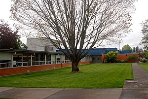
Sunset High School (Beaverton, Oregon)
Public school in Portland, , Oregon, United States
Distance: Approx. 2456 meters
Latitude and longitude: 45.5285,-122.8201
Sunset High School (SHS) is a public high school in Beaverton, Oregon, United States. The school currently offers the International Baccalaureate Diploma Programme. It opened in 1959 and is the second oldest of the six high schools in the Beaverton School District.

Columbia Sportswear
American company that manufactures and distributes outerwear and sportswear
Distance: Approx. 2272 meters
Latitude and longitude: 45.52938,-122.82535
The Columbia Sportswear Company is an American company that manufactures and distributes outerwear, sportswear, and footwear, as well as headgear, camping equipment, ski apparel, and outerwear accessories. It was founded in 1938 by Paul Lamfrom, the father of Gert Boyle. The company is headquartered in Cedar Mill, an unincorporated area in Washington County, Oregon, in the Portland metropolitan area near Beaverton.
Five Oaks Museum
History museum in Washington County, Oregon, United States
Distance: Approx. 2881 meters
Latitude and longitude: 45.566232,-122.857615
Five Oaks Museum, formerly known as the Washington County Museum, is a history museum in Washington County, Oregon, United States. It is located at the Rock Creek campus of Portland Community College (PCC), north of Beaverton, Oregon. From 2012 to 2017, its public exhibit space was located in downtown Hillsboro, Oregon, before it was moved back to PCC, its pre-2012 location and where the museum's research facility had already been located.

Historic Washington County Jail (Oregon)
United States historic place
Distance: Approx. 2885 meters
Latitude and longitude: 45.56638889,-122.8575
The Historic Washington County Jail is a log, one-room jail previously used in Oregon. It was built in 1853 and was used until 1870. In 1986, it was listed on the National Register of Historic Places (NRHP), and is preserved by the Washington County Museum in Washington County, Oregon, United States and is exhibited outside of the museum near its entrance.

Bethany, Oregon
Unincorporated community in the state of Oregon, United States
Distance: Approx. 1441 meters
Latitude and longitude: 45.56138889,-122.83694444
Bethany is an unincorporated community and census-designated place in Washington County, Oregon, United States. It is situated north of U.S. Route 26 and Oak Hills, near Beaverton, approximately four miles northwest of Cedar Mill, and is within the Portland metropolitan area.
Columbia Montrail
Sub-brand of Columbia Sportswear
Distance: Approx. 2272 meters
Latitude and longitude: 45.52938,-122.82535
Columbia Montrail is a sub-brand of Columbia Sportswear that manufactures and distributes shoes for trail running, hiking, and general long-distance running.
Leupold & Stevens
American eyewear manufacturer
Distance: Approx. 2922 meters
Latitude and longitude: 45.5238,-122.82243
Leupold & Stevens, Inc. is an American manufacturer of telescopic sights, red dot sights, binoculars, rangefinders, spotting scopes, and eyewear located in Beaverton, Oregon, United States. The company, started in 1907, is on its fifth generation of family ownership.
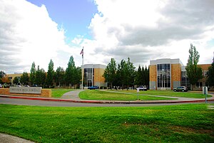
Westview High School (Portland, Oregon)
Public school in Portland, Oregon, United States
Distance: Approx. 2783 meters
Latitude and longitude: 45.55,-122.865
Westview High School (WHS) is a public high school in an unincorporated part of Washington County, Oregon, United States, within the Portland metropolitan area, and in the Beaverton School District. It opened in 1994 and its first graduating class was in June 1996.

Enli Health Intelligence
Distance: Approx. 2513 meters
Latitude and longitude: 45.531261,-122.8481
Enli Health Intelligence was a privately held software company based in Beaverton, Oregon, and previously in Hillsboro, Oregon. Founded in 2001 as Kryptiq Corporation, the company specialized in electronic medical records and secure communications between physicians and patients. The 125-employee company was purchased by Surescripts in 2012, which was a previous investor in the company.

Howard M. Terpenning Recreation Complex
Distance: Approx. 3329 meters
Latitude and longitude: 45.5201,-122.8363
The Howard M. Terpenning Recreation Complex, often called the Terpenning Recreation Complex or simply the THPRD recreation complex, is a 92-acre recreation complex in Beaverton, Oregon. It is owned and operated by the Tualatin Hills Park and Recreation District (THPRD) and serves as the location of the district's administrative offices. The complex, in addition to the administrative offices, houses an indoor Olympic swimming pool, a tennis center, an athletic center, and several sports fields, as well as a natural area.
Weather in this IP's area
broken clouds
20 Celsius
19 Celsius
18 Celsius
21 Celsius
1023 hPa
66 %
1023 hPa
1014 hPa
10000 meters
4.12 m/s
90 degree
75 %
07:33:37
18:18:23