206.41.79.180 - IP Lookup: Free IP Address Lookup, Postal Code Lookup, IP Location Lookup, IP ASN, Public IP
Country:
Region:
City:
Location:
Time Zone:
Postal Code:
IP information under different IP Channel
ip-api
Country
Region
City
ASN
Time Zone
ISP
Blacklist
Proxy
Latitude
Longitude
Postal
Route
Luminati
Country
ASN
Time Zone
Europe/London
ISP
IX Reach Ltd
Latitude
Longitude
Postal
IPinfo
Country
Region
City
ASN
Time Zone
ISP
Blacklist
Proxy
Latitude
Longitude
Postal
Route
IP2Location
206.41.79.180Country
Region
england
City
cheadle
Time Zone
Europe/London
ISP
Language
User-Agent
Latitude
Longitude
Postal
db-ip
Country
Region
City
ASN
Time Zone
ISP
Blacklist
Proxy
Latitude
Longitude
Postal
Route
ipdata
Country
Region
City
ASN
Time Zone
ISP
Blacklist
Proxy
Latitude
Longitude
Postal
Route
Popular places and events near this IP address

Cheadle, Staffordshire
Town in Staffordshire, England
Distance: Approx. 279 meters
Latitude and longitude: 52.9849,-1.9865
Cheadle is a market town and civil parish in the Staffordshire Moorlands District of Staffordshire, England, with a population of 12,000 at the 2021 census. It is located between Uttoxeter, Leek, Ashbourne and Stoke-on-Trent. Dating back to Anglo-Saxon times, it lies within the historic Staffordshire Hundred of Totmonslow; for administrative purposes, it is now part of the Staffordshire Moorlands area.
Moorlands Sixth Form College
Sixth form college in Cheadle, Staffordshire, England
Distance: Approx. 669 meters
Latitude and longitude: 52.9794,-1.9909
The Moorlands Sixth Form College is a Sixth Form College located in Cheadle, a historic market town in Staffordshire, England. The college caters for years 12-13, where students can gain A-Level and AS-Level qualifications, with results above the national standards. The college is run as a partnership of 3 local high schools; Painsley Catholic College, The Cheadle Academy and Moorside High School, and acts as the sixth form for students of all partnership schools.
The Cheadle Academy
Academy in Cheadle, Stoke-on-Trent, Staffordshire, England
Distance: Approx. 487 meters
Latitude and longitude: 52.9816,-1.99
The Cheadle Academy (formerly Cheadle High School) is a coeducational secondary school with academy status located in Cheadle, Staffordshire in the Midlands area of England. It has around 790 pupils ranging from Year 7 to 13. The Cheadle Academy has its own sixth form provision that opened in September 2017.
Tean Road Sports Ground
Distance: Approx. 442 meters
Latitude and longitude: 52.9796,-1.9857
Tean Road Sports Ground is a cricket ground in Cheadle, Staffordshire. The ground is located south of the town centre along the Tean Road, which itself forms part of the A522 Road. It has played host to List A cricket matches, in addition to playing host to Staffordshire County Cricket Club in minor counties cricket.
Painsley Catholic College
Academy in Staffordshire, England
Distance: Approx. 416 meters
Latitude and longitude: 52.981714,-1.988914
Painsley Catholic College is a Roman Catholic secondary school with academy status in Cheadle, Staffordshire, England. The name comes from Painsley Hall, Draycott in the Moors, from which the Painsley and Draycott Mission served the neighbouring areas and from which grew those parishes now connected with the college. It is also part of a multi-academy company made up of Painsley and its six feeder schools.

St Giles' Catholic Church, Cheadle
Church in England
Distance: Approx. 486 meters
Latitude and longitude: 52.986,-1.989
St Giles' Church is a Roman Catholic church in the town of Cheadle, Staffordshire, England. The Grade I listed Gothic Revival church was designed by Augustus Welby Northmore Pugin and built between 1841 and 1846 for the Earl of Shrewsbury. It is in Decorated style, and is highly decorated on the outside and the inside, and has a tall steeple.

Cheadle Coalfield
Coalfield in Staffordshire, England
Distance: Approx. 2170 meters
Latitude and longitude: 53,-2
The Cheadle Coalfield is a coalfield in the United Kingdom. Centred on the town of Cheadle, Staffordshire, and its outlying villages it lies to the east of Stoke-on-Trent and the much larger North Staffordshire Coalfield. The area has been mined for many years, with documentary evidence from Croxden Abbey citing coal mining in the 13th century.

Cheadle railway station
Former station in Staffordshire 1901–1963
Distance: Approx. 706 meters
Latitude and longitude: 52.9807,-1.9929
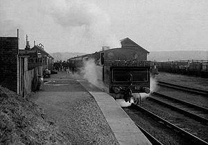
Cheadle railway station served the town of Cheadle, Staffordshire, England. It was the terminus of a branch line from Cresswell and opened in 1901.
Freehay
Distance: Approx. 1764 meters
Latitude and longitude: 52.9697,-1.9698
Freehay is a small village located 2 miles from the centre of Cheadle in Staffordshire, England.
Woodhead Hall
Country house in Cheadle, Staffordshire, UK
Distance: Approx. 2305 meters
Latitude and longitude: 53.0006,-1.9644
Woodhead Hall is a country house at Cheadle in Staffordshire. It is a Grade II listed building.
Cheadle Rural District
Former rural district in Staffordshire, England
Distance: Approx. 867 meters
Latitude and longitude: 52.99075,-1.98705
Cheadle Rural District was a rural district in the administrative county of Staffordshire, England from 1894 to 1974, covering an area in the north of the county centred on the small town of Cheadle.
Osborne House, Cheadle
Former municipal building in Cheadle, Staffordshire, England
Distance: Approx. 660 meters
Latitude and longitude: 52.9886,-1.9877
Osborne House, formerly Cheadle Town Hall, is a former municipal building in Leek Road in Cheadle, Staffordshire, a town in England. The building retains the façade of the former town hall but has been extensively redeveloped for residential use behind the façade.
Weather in this IP's area
overcast clouds
10 Celsius
10 Celsius
9 Celsius
11 Celsius
1023 hPa
100 %
1023 hPa
1004 hPa
10000 meters
2.41 m/s
7.26 m/s
262 degree
99 %
