206.40.238.92 - IP Lookup: Free IP Address Lookup, Postal Code Lookup, IP Location Lookup, IP ASN, Public IP
Country:
 USA
USARegion:
City:
Location:
Time Zone:
Postal Code:
ISP:
ASN:
language:
User-Agent:
Proxy IP:
Blacklist:
IP information under different IP Channel
ip-api
Country
Region
City
ASN
Time Zone
ISP
Blacklist
Proxy
Latitude
Longitude
Postal
Route
db-ip
Country
Region
City
ASN
Time Zone
ISP
Blacklist
Proxy
Latitude
Longitude
Postal
Route
IPinfo
Country
Region
City
ASN
Time Zone
ISP
Blacklist
Proxy
Latitude
Longitude
Postal
Route
IP2Location
206.40.238.92Country
usRegion
louisiana
City
morgan city
Time Zone
America/Chicago
ISP
Language
User-Agent
Latitude
Longitude
Postal
ipdata
Country
Region
City
ASN
Time Zone
ISP
Blacklist
Proxy
Latitude
Longitude
Postal
Route
Popular places and events near this IP address

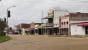
Berwick, Louisiana
Town in Louisiana, United States
Distance: Approx. 1310 meters
Latitude and longitude: 29.69805556,-91.22694444
Berwick is a town in St. Mary Parish, Louisiana, United States. The population was 4,946 at the 2010 census.
Morgan City, Louisiana
City in Louisiana, United States
Distance: Approx. 1588 meters
Latitude and longitude: 29.70083333,-91.19722222
Morgan City is a small city in St. Mary Parish, Louisiana, United States, located in the Acadiana region. The population was 11,472 at the 2020 census.

Berwick Bay
Section of lower Atchafalaya River in Louisiana, United States
Distance: Approx. 489 meters
Latitude and longitude: 29.7013,-91.2172
Berwick Bay is the section of the Lower Atchafalaya River in Louisiana from Morgan City north to Sixmile Lake. U.S. Route 90 crosses Berwick Bay connecting the town of Berwick on the west bank of the Atchafalaya to Morgan City on the east bank. There is also a Southern Pacific vertical lift bridge connecting the two municipalities.
Central Catholic High School (Morgan City, Louisiana)
School in Morgan City, United States
Distance: Approx. 1737 meters
Latitude and longitude: 29.71305556,-91.20722222
Central Catholic High School is a private, Catholic high school in Morgan City, Louisiana. It is located in the Roman Catholic Diocese of Houma-Thibodaux.

USS Kinsman
Gunboat of the United States Navy
Distance: Approx. 1333 meters
Latitude and longitude: 29.707,-91.223
USS Kinsman, sometimes called USS Colonel Kinsman, was a sidewheel steamer captured by the Union Army during the American Civil War. She was used by the Army and then by the Union Navy as a gunboat in support of the Union Navy blockade of Confederate waterways. On 23 February 1863, she hit a snag and sank.

Morgan City High School
Public school in Morgan City, Louisiana, United States
Distance: Approx. 2253 meters
Latitude and longitude: 29.71695,-91.20409
Morgan City High School is a public secondary school located in Morgan City, Louisiana, United States. It is operated by the St. Mary Parish School Board.
E. J. "Lionel" Grizzaffi Bridge
Bridge in Berwick and Morgan City, Louisiana
Distance: Approx. 304 meters
Latitude and longitude: 29.6957,-91.2139
The E. J. "Lionel" Grizzaffi Bridge is a cantilever bridge in the U.S. state of Louisiana which carries US 90 over the Atchafalaya River between Berwick and Morgan City. Before the 1975 opening, US 90 followed the Long–Allen Bridge. The bridge will eventually be part of the I-49 extension between Lafayette and New Orleans once the highway is brought up to interstate highway standards.

Berwick Bay Bridge
Bridge in Berwick and Morgan City, Louisiana
Distance: Approx. 663 meters
Latitude and longitude: 29.6925,-91.2125
The Berwick Bay Bridge is a vertical lift bridge in the U.S. state of Louisiana which carries the BNSF Railway over the Atchafalaya River between Berwick and Morgan City. The bridge is primarily used for freight, but Amtrak runs the Sunset Limited three times weekly per direction over the line.

Long–Allen Bridge (Morgan City)
Bridge in the United States of America
Distance: Approx. 208 meters
Latitude and longitude: 29.6967,-91.2143
The Long–Allen Bridge is a truss bridge in the U.S. state of Louisiana which carries LA 182 over the Atchafalaya River between Berwick and Morgan City. This bridge was built by the Mt. Vernon Bridge Co.
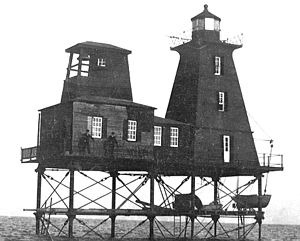
Southwest Reef Light
Lighthouse in Louisiana, US
Distance: Approx. 538 meters
Latitude and longitude: 29.69427778,-91.21630556
Southwest Reef Light is a historic lighthouse built in 1856 at the end of Southwest Reef in Atchafalaya Bay, Louisiana to replace lightships which had been stationed there for ten years. It served to guide vessels around the reef and into the main channel of the Atchafalaya River. It was discontinued in 1916 after a new, shorter and deeper, channel had been dredged across the reef, making it obsolete.

Atkinson Memorial Presbyterian Church
Historic church in Louisiana, United States
Distance: Approx. 1343 meters
Latitude and longitude: 29.69277778,-91.20111111
Atkinson Memorial Presbyterian Church is a historic Presbyterian church at 214 Fourth Street in Morgan City, Louisiana. It was built in 1916 in a Bungalow and Gothic Revival style. Its Gothic Revival features include lanced windows on either side of the nave, a pointed arch on the entrance porch, and a pitched roof supported by exposed trusses.

Pharr Chapel United Methodist Church
Church in Louisiana, United States
Distance: Approx. 789 meters
Latitude and longitude: 29.69613889,-91.20566667
Pharr Chapel United Methodist Church was established in 1878 in Morgan City, LA, through donations made by the Pharr family.
Weather in this IP's area
overcast clouds
23 Celsius
24 Celsius
23 Celsius
23 Celsius
1020 hPa
88 %
1020 hPa
1020 hPa
10000 meters
2.57 m/s
320 degree
100 %