Country:
 USA
USARegion:
City:
Latitude and Longitude:
Time Zone:
Postal Code:
IP information under different IP Channel
ip-api
Country
Region
City
ASN
Time Zone
ISP
Blacklist
Proxy
Latitude
Longitude
Postal
Route
IPinfo
Country
Region
City
ASN
Time Zone
ISP
Blacklist
Proxy
Latitude
Longitude
Postal
Route
MaxMind
Country
Region
City
ASN
Time Zone
ISP
Blacklist
Proxy
Latitude
Longitude
Postal
Route
Luminati
Country
USASN
Time Zone
America/Chicago
ISP
LIGHTEDGE-AS-02
Latitude
Longitude
Postal
db-ip
Country
Region
City
ASN
Time Zone
ISP
Blacklist
Proxy
Latitude
Longitude
Postal
Route
ipdata
Country
Region
City
ASN
Time Zone
ISP
Blacklist
Proxy
Latitude
Longitude
Postal
Route
Popular places and events near this IP address
Miramar, San Diego
Community of San Diego in California
Distance: Approx. 556 meters
Latitude and longitude: 32.88638889,-117.15777778
Miramar (Spanish for "Sea View") is a neighborhood in the northern part of San Diego, California, United States. It includes residential areas and commercial and light industrial districts. Most residents live on Marine Corps Air Station Miramar (formerly Naval Air Station Miramar).
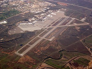
Marine Corps Air Station Miramar
USMC installation that is home to the 3rd Marine Aircraft Wing
Distance: Approx. 2227 meters
Latitude and longitude: 32.86777778,-117.14166667
Marine Corps Air Station Miramar (MCAS Miramar) (IATA: NKX, ICAO: KNKX, FAA LID: NKX) is a United States Marine Corps installation that is home to the 3rd Marine Aircraft Wing, which is the aviation element of the 1st Marine Expeditionary Force. It is located in Miramar, a community of San Diego, California, about 14 miles (23 km) north of downtown San Diego. The airfield has been named Mitscher Field since 1955, after Admiral M.A. Mitscher, who was the commander of Task Force 58 during World War II. The air station is the former location of Pacific Fleet fighter and Airborne Early Warning and Control aircraft (F-4 Phantom II, F-14 Tomcat, E-2 Hawkeye) and is best known as the former location of the United States Navy Fighter Weapons School (NFWS), its TOPGUN training program and the movie of the same name.

Miramar Air Show
San Diego air show
Distance: Approx. 2227 meters
Latitude and longitude: 32.86777778,-117.14166667
The Miramar Air Show is an annual air show in San Diego, California, held at Marine Corps Air Station Miramar. The three-day event is the largest military air show in the United States, with total annual attendance estimated at 700,000. In 2007, it was voted the "World's Best Military Air Show" by the International Council of Air Shows, the first time the award was given to a Marine Corps air station since 1994.

AleSmith Brewing Company
Craft brewery in San Diego, California
Distance: Approx. 1782 meters
Latitude and longitude: 32.89206667,-117.14468611
AleSmith Brewing Company is an American craft brewery located in San Diego, California. It specializes in handcrafted ales in a variety of styles. As of 2015 it produces about 25,000 barrels of beer a year.
California's 52nd congressional district
U.S. House district for California
Distance: Approx. 2344 meters
Latitude and longitude: 32.87,-117.18
California's 52nd congressional district is a congressional district in the U.S. state of California. The district is currently represented by Democrat Juan Vargas. The district currently includes southwestern portions of San Diego County.
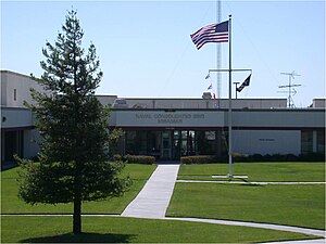
Naval Consolidated Brig, Miramar
US Navy military prison in San Diego, California
Distance: Approx. 680 meters
Latitude and longitude: 32.88,-117.15194444
Naval Consolidated Brig, Miramar (NAVCONBRIG) is a military prison operated by the U.S. Navy at Marine Corps Air Station Miramar in Miramar in San Diego, California, just under 10 miles (16 km) north of downtown San Diego. It is one of three Navy consolidated brigs and is the Pacific area regional confinement facility for the United States Department of Defense. It is also known as the Joint Regional Correctional Facility Southwest.
Illumina, Inc.
American biotechnology company
Distance: Approx. 1479 meters
Latitude and longitude: 32.8875924,-117.1730577
Illumina, Inc. is an American biotechnology company, headquartered in San Diego, California. Incorporated on April 1, 1998, Illumina develops, manufactures, and markets integrated systems for the analysis of genetic variation and biological function.
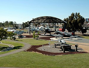
Flying Leatherneck Aviation Museum
Military aviation museum in California, United States
Distance: Approx. 2141 meters
Latitude and longitude: 32.89111111,-117.13916667
The Flying Leatherneck Aviation Museum is a United States Marine Corps aviation museum currently located at Marine Corps Air Station Miramar, San Diego, California. The museum contains exhibits and artifacts relating to the history and legacy of United States Marine Corps Aviation. The outdoor exhibits include 31 historical aircraft, multiple military vehicles and equipment.

El Camino Memorial Park
Cemetery in Sorrento Valley, California, USA
Distance: Approx. 2969 meters
Latitude and longitude: 32.8931,-117.1876
El Camino Memorial Park is a cemetery in the Sorrento Valley neighborhood of San Diego, California. Founded in 1960, it is a 220-acre (0.89 km2) property. The cemetery is noted for being the final resting site for Jonas Salk as well as several members of the well-known Kroc family.
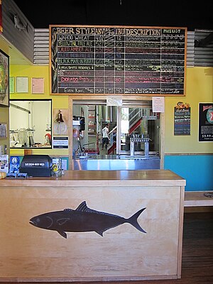
Ballast Point Brewing Company
Brewery in San Diego, California
Distance: Approx. 678 meters
Latitude and longitude: 32.88753333,-117.15803056
Ballast Point Brewing Company is an American brewery founded in 1996 by Jack White in San Diego, California. Ballast Point Brewing Co. started in the back of Home Brew Mart, a homebrew supply store White founded in 1992.
Sorrento Mesa, San Diego
Distance: Approx. 1975 meters
Latitude and longitude: 32.88916667,-117.17805556
Sorrento Mesa is a neighborhood in northwestern San Diego, California. It lies on a mesa with many ridges, north of Carrol Canyon Road, east of Interstate 805, west of Camino Santa Fe, and south of a canyon locally known as Lopez Canyon. The San Diego Police Department's neighborhood map shows Sorrento Mesa as part of the Sorrento Valley neighborhood.

Miramar National Cemetery
Veterans cemetery in San Diego County, California
Distance: Approx. 2895 meters
Latitude and longitude: 32.87388889,-117.18861111
Miramar National Cemetery is a federal military cemetery in San Diego, California. It is located in the northwest corner of Marine Corps Air Station Miramar on the grounds of former Camp Kearny (1917) and Camp Elliott (1942). The cemetery is considered an auxiliary of Fort Rosecrans National Cemetery and is administered by the United States Department of Veterans Affairs.
Weather in this IP's area
few clouds
22 Celsius
21 Celsius
19 Celsius
24 Celsius
1013 hPa
59 %
1013 hPa
998 hPa
10000 meters
5.14 m/s
250 degree
20 %
06:55:21
18:11:39