Country:
 USA
USARegion:
City:
Latitude and Longitude:
Time Zone:
Postal Code:
IP information under different IP Channel
ip-api
Country
Region
City
ASN
Time Zone
ISP
Blacklist
Proxy
Latitude
Longitude
Postal
Route
IPinfo
Country
Region
City
ASN
Time Zone
ISP
Blacklist
Proxy
Latitude
Longitude
Postal
Route
MaxMind
Country
Region
City
ASN
Time Zone
ISP
Blacklist
Proxy
Latitude
Longitude
Postal
Route
Luminati
Country
USASN
Time Zone
America/Chicago
ISP
LIGHTEDGE-AS-02
Latitude
Longitude
Postal
db-ip
Country
Region
City
ASN
Time Zone
ISP
Blacklist
Proxy
Latitude
Longitude
Postal
Route
ipdata
Country
Region
City
ASN
Time Zone
ISP
Blacklist
Proxy
Latitude
Longitude
Postal
Route
Popular places and events near this IP address

Preuss School
Charter school in La Jolla, California
Distance: Approx. 2426 meters
Latitude and longitude: 32.882855,-117.222432
The Preuss School, Preuss School UCSD, or Preuss Model School ( PROYSS) is a coeducational college-preparatory charter day school established on a $14 million campus, situated on the University of California, San Diego campus in the La Jolla community of San Diego, California. The school was named in recognition of a gift from the Preuss Family Foundation and is chartered under the San Diego Unified School District (SDUSD). Founded in 1999 in the wake of passage of California Proposition 209, Preuss uses an intensive college preparatory curriculum to educate low-income students between sixth and twelfth grade, hoping to improve their historical under-representation on the campuses of the University of California.

La Jolla Country Day School
Independent/private school
Distance: Approx. 2481 meters
Latitude and longitude: 32.87833333,-117.21694444
La Jolla Country Day School (known informally as "Country Day" or "LJCDS") is an independent school in University City, a community of San Diego, California. The school contains a lower school (consisting of nursery through fourth grade), a middle school (grades 5–8), and an upper school (grades 9–12). The school's motto is "Scientia Pacifica" (peace through knowledge).

Sorrento Valley, San Diego
Community of San Diego in California
Distance: Approx. 1755 meters
Latitude and longitude: 32.9025,-117.18527778
Sorrento Valley is a neighborhood of San Diego, California. It is roughly bounded by Interstate 5 and Interstate 805, Camino Santa Fe to the east, the Los Peñasquitos Canyon Preserve to the north and Miramar Road to the south, as shown on the San Diego Police Department's neighborhood map. It encompasses Sorrento Mesa and is part of the San Diego Unified School District.
KHHS-LP
Radio station in California, United States
Distance: Approx. 2338 meters
Latitude and longitude: 32.87777778,-117.21222222
KHHS-LP (107.5 FM) was a radio station broadcasting a Christian radio format. Licensed to San Diego, California, United States, the station was owned by Horizon Christian Fellowship. Horizon Christian Fellowship surrendered the station's license to the Federal Communications Commission (FCC) on June 19, 2015.
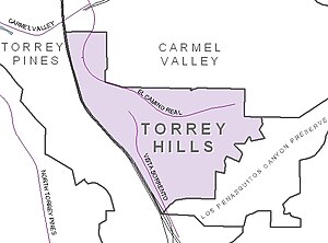
Torrey Hills, San Diego
Community of San Diego in California
Distance: Approx. 2659 meters
Latitude and longitude: 32.91126111,-117.22608889
Torrey Hills is a community of 784 acres (317 ha) located in northern San Diego, California, United States. Torrey Hills is a part of District 1 which is represented by Councilmember Joe LaCava on the San Diego City Council.

Sorrento Valley station
Passenger train station in San Diego, California, United States
Distance: Approx. 2152 meters
Latitude and longitude: 32.903,-117.225
Sorrento Valley station is a commuter rail station in the Sorrento Valley neighborhood of San Diego, California that is on the NCTD COASTER commuter rail line. The station is served by NCTD COASTER Connection shuttles to the businesses east of the station, the community of Torrey Pines, University of California, San Diego, and the Westfield UTC Mall. On October 7, 2013, the Amtrak Pacific Surfliner began stopping at four COASTER stations: Carlsbad Village, Carlsbad Poinsettia, Encinitas and Sorrento Valley.
San Diego Jewish Film Festival
Annual film festival
Distance: Approx. 2740 meters
Latitude and longitude: 32.87597222,-117.21763889
The San Diego Jewish Film Festival (SDJFF) is an annual eleven-day-long film festival held in San Diego, California. Established in 1990, the festival is managed by the San Diego Center for Jewish Culture, at the Lawrence Family Jewish Community Center in La Jolla. The festival usually consists of around fifty narrative, documentary, and short films, often with post-film audience discussions with the filmmakers.

La Jolla Institute for Immunology
Research institute near San Diego, California, U.S.
Distance: Approx. 2740 meters
Latitude and longitude: 32.87721,-117.21993
La Jolla Institute for Immunology is a non-profit research organization in La Jolla, a community of San Diego, California. The institute was founded in 1988. It is located in UC San Diego’s Research Park.

El Camino Memorial Park
Cemetery in Sorrento Valley, California, USA
Distance: Approx. 1513 meters
Latitude and longitude: 32.8931,-117.1876
El Camino Memorial Park is a cemetery in the Sorrento Valley neighborhood of San Diego, California. Founded in 1960, it is a 220-acre (0.89 km2) property. The cemetery is noted for being the final resting site for Jonas Salk as well as several members of the well-known Kroc family.
Sorrento Mesa, San Diego
Distance: Approx. 2501 meters
Latitude and longitude: 32.88916667,-117.17805556
Sorrento Mesa is a neighborhood in northwestern San Diego, California. It lies on a mesa with many ridges, north of Carrol Canyon Road, east of Interstate 805, west of Camino Santa Fe, and south of a canyon locally known as Lopez Canyon. The San Diego Police Department's neighborhood map shows Sorrento Mesa as part of the Sorrento Valley neighborhood.
Green Flash Brewing Company
Distance: Approx. 2616 meters
Latitude and longitude: 32.9068,-117.1774
Green Flash Brewing Company is an American craft brewery headquartered in the Mira Mesa neighborhood of San Diego, California, and founded in 2002. In early April 2018, the company sold to a group of investors, WC IPA LLC following a foreclosure by the company’s principal lender, Comerica Bank. Starting in 2013 it began expanding, seeking to cover all 50 US states and to export as well.

UC San Diego Health La Jolla station
San Diego Trolley station
Distance: Approx. 2581 meters
Latitude and longitude: 32.881902,-117.223638
UC San Diego Health La Jolla station is a San Diego Trolley station located on the UC San Diego East Campus, which includes the UC San Diego Health La Jolla campus of hospitals and medical facilities and the Preuss School. The station is elevated just south of Voigt Drive at Campus Point Drive. A bridge directly connects the platform level with Scripps Memorial Hospital La Jolla.
Weather in this IP's area
clear sky
26 Celsius
26 Celsius
24 Celsius
30 Celsius
1006 hPa
60 %
1006 hPa
998 hPa
10000 meters
2.24 m/s
4.92 m/s
22 degree
06:28:26
19:04:29