Country:
 USA
USARegion:
City:
Latitude and Longitude:
Time Zone:
Postal Code:
IP information under different IP Channel
ip-api
Country
Region
City
ASN
Time Zone
ISP
Blacklist
Proxy
Latitude
Longitude
Postal
Route
IPinfo
Country
Region
City
ASN
Time Zone
ISP
Blacklist
Proxy
Latitude
Longitude
Postal
Route
MaxMind
Country
Region
City
ASN
Time Zone
ISP
Blacklist
Proxy
Latitude
Longitude
Postal
Route
Luminati
Country
USASN
Time Zone
America/Chicago
ISP
LIGHTEDGE-AS-02
Latitude
Longitude
Postal
db-ip
Country
Region
City
ASN
Time Zone
ISP
Blacklist
Proxy
Latitude
Longitude
Postal
Route
ipdata
Country
Region
City
ASN
Time Zone
ISP
Blacklist
Proxy
Latitude
Longitude
Postal
Route
Popular places and events near this IP address
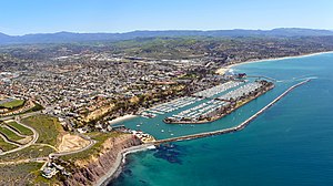
Dana Point, California
City in California, United States
Distance: Approx. 844 meters
Latitude and longitude: 33.46722222,-117.69805556
Dana Point () is a city located in southern Orange County, California, United States. The population was 33,107 at the 2020 census. It has one of the few harbors along the Orange County coast, and with ready access via State Route 1, it is a popular local destination for surfing.

Capistrano Beach, Dana Point, California
District of Dana Point in California, United States
Distance: Approx. 1673 meters
Latitude and longitude: 33.4625,-117.67166667
Capistrano Beach or Capo Beach, is a coastal neighborhood in the city of Dana Point in Orange County, California. It is bordered by San Clemente to the south and Doheny State Beach to the north. Capistrano Beach is situated along the coast on the southern end of Dana Point.

Doheny State Beach
State park in California, United States
Distance: Approx. 1202 meters
Latitude and longitude: 33.46083333,-117.67805556
Doheny State Beach (known colloquially as Doho) is known as the first state beach in the California state park system. Located on the Pacific Ocean in the city of Dana Point, the beach is adjacent to several surf spots and scenic beaches including Salt Creek Beach, Baby Beach, and Capistrano Beach. Along with its neighbors, Doheny beach is a popular surf spot located at the mouth of San Juan Creek, which flows from the Santa Ana Mountains southwest to the beach, where it forms a fresh-water lagoon.

Dana Hills High School
Public school in Dana Point, California, United States
Distance: Approx. 1643 meters
Latitude and longitude: 33.47777778,-117.70055556
Dana Hills High School is a high school in Dana Point, California opened in 1973. The school's enrollment of roughly 2,000 students is drawn from the nearby communities of Laguna Niguel, Dana Point, Capistrano Beach, and San Juan Capistrano. When Dana Hills was built in 1972–73, the area was an unincorporated area of Orange County.
Coastland University
University in California, United States
Distance: Approx. 910 meters
Latitude and longitude: 33.467652,-117.698722
Coastland University (also known as Coastland Christian Bible College and University) began holding classes in 1999. It is an unaccredited, non-denominational, non-profit, co-educational Christian Bible college located in Southern California, United States. It uses classroom space at area churches and other venues rather than a dedicated campus.

San Juan Creek
River in Orange County, California, United States
Distance: Approx. 743 meters
Latitude and longitude: 33.46166667,-117.68361111
San Juan Creek, also called the San Juan River, is a 29-mile (47 km) long stream in Orange and Riverside Counties, draining a watershed of 133.9 square miles (347 km2). Its mainstem begins in the southern Santa Ana Mountains in the Cleveland National Forest. It winds west and south through San Juan Canyon, and is joined by Arroyo Trabuco as it passes through San Juan Capistrano.

Ocean Institute
Distance: Approx. 1745 meters
Latitude and longitude: 33.4611,-117.7066
The Ocean Institute is an ocean education organization located in Dana Point, California. Founded as the Orange County Marine Institute in 1977, it offers ocean science and maritime history programs for K–12 students and their teachers. Over 100,000 students and 8,000 teachers from Orange County and the surrounding counties participate yearly in immersion-style programs in the institute's oceanfront labs and abroad.

Course of San Juan Creek
Distance: Approx. 737 meters
Latitude and longitude: 33.4616945,-117.6836625
San Juan Creek is a creek in Orange County in the U.S. state of California. It is about 29 miles (47 km) long, and along with its major tributary, Trabuco Creek, drains 133 square miles (340 km2) near the southernmost extent of Orange County. This article describes the course of San Juan Creek.
Suicide of Holly Glynn
1987 event in Dana Point, California
Distance: Approx. 2149 meters
Latitude and longitude: 33.46155,-117.71134
Holly Jo Glynn (September 11, 1966 – September 20, 1987) was a formerly unidentified American woman who committed suicide in September 1987 by jumping off a cliff in Dana Point, California. Her body remained unidentified until 2015, when concerns previously expressed by friends of Glynn that the unidentified woman may have been their childhood friend, whom they had been unable to locate for several years, were proven.
Orange County Blues Festival
Former blues festival in Dana Point, California
Distance: Approx. 865 meters
Latitude and longitude: 33.462931,-117.697216
The Orange County Blues Festival was an annual multi-day blues event held in Dana Point, California. Similar to the nearby Topanga Canyon Blues Festival, it attracted some of the major blues artists in the United States. Some of the most notable artists to have appeared there are Canned Heat, Johnny Copeland and Etta James.
The Coach House (San Juan Capistrano, California)
Distance: Approx. 2370 meters
Latitude and longitude: 33.4821,-117.6715
The Coach House is a music venue located at 33157 Camino Capistrano in San Juan Capistrano, California. The venue opened in 1980. It hosts aspiring artists as well as those established in the industry.
Doheny Desalination Plant
Distance: Approx. 735 meters
Latitude and longitude: 33.46611111,-117.68111111
The Doheny Desalination Plant is a 5-million-US-gallon per day (19 Ml) facility proposed by South Coast Water District in Dana Point, California. The 30-acre site (12 ha) is just north of State Route 1 on east side of San Juan Creek with access off Stonehill Drive. The Joint Regional Water Supply System will distribute desalinated water existing water transmission lines to South Coast Water District customers and south Orange County.
Weather in this IP's area
clear sky
23 Celsius
23 Celsius
21 Celsius
26 Celsius
1013 hPa
65 %
1013 hPa
1010 hPa
10000 meters
1.79 m/s
4.47 m/s
171 degree
2 %
06:58:01
18:13:13