Country:
 USA
USARegion:
City:
Latitude and Longitude:
Time Zone:
Postal Code:
IP information under different IP Channel
ip-api
Country
Region
City
ASN
Time Zone
ISP
Blacklist
Proxy
Latitude
Longitude
Postal
Route
IPinfo
Country
Region
City
ASN
Time Zone
ISP
Blacklist
Proxy
Latitude
Longitude
Postal
Route
MaxMind
Country
Region
City
ASN
Time Zone
ISP
Blacklist
Proxy
Latitude
Longitude
Postal
Route
Luminati
Country
USASN
Time Zone
America/Chicago
ISP
LIGHTEDGE-AS-02
Latitude
Longitude
Postal
db-ip
Country
Region
City
ASN
Time Zone
ISP
Blacklist
Proxy
Latitude
Longitude
Postal
Route
ipdata
Country
Region
City
ASN
Time Zone
ISP
Blacklist
Proxy
Latitude
Longitude
Postal
Route
Popular places and events near this IP address

Littleton Common, Massachusetts
Census-designated place in Massachusetts, United States
Distance: Approx. 2373 meters
Latitude and longitude: 42.54611111,-71.47297778
Littleton Common is a census-designated place (CDP) in the town of Littleton in Middlesex County, Massachusetts, United States. The population was 3,065 at the 2020 census, up from 2,789 in 2010.

Westford, Massachusetts
Town in Massachusetts, United States
Distance: Approx. 2873 meters
Latitude and longitude: 42.57916667,-71.43833333
Westford is a town in Middlesex County, Massachusetts, United States. The population was at 24,643 at the time of the 2020 Census.

Nashoba Valley Ski Area
Ski area in Westford, Massachusetts
Distance: Approx. 1349 meters
Latitude and longitude: 42.541975,-71.44410278
Nashoba Valley Ski Area is a ski area in Westford, Massachusetts, United States, located at 79 Powers Road. It borders on Littleton, Massachusetts and has been operating each winter since opening in 1964. It has 17 ski trails as well as a terrain park and tubing park.

Westford Academy
Public school in the United States
Distance: Approx. 2945 meters
Latitude and longitude: 42.57702778,-71.46377778
Westford Academy is the public high school for the town of Westford, Massachusetts, United States. It was incorporated in 1792 and is one of the oldest public high schools in the United States.
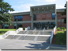
Nashoba Valley Technical High School
Public regional vocational technical school in Westford, Massachusetts, USA
Distance: Approx. 2238 meters
Latitude and longitude: 42.56721944,-71.42554167
Nashoba Valley Technical High School is a four-year, public regional vocational high school located on Route 110 in Westford, Massachusetts, United States. Following a $25 million renovation and expansion, its service area covers 14 communities including the seven District towns of Ayer, Chelmsford, Groton, Littleton, Pepperell, Shirley, Townsend and Westford.

Old Burying Ground (Littleton, Massachusetts)
Historic cemetery in Massachusetts, United States
Distance: Approx. 2687 meters
Latitude and longitude: 42.5452396,-71.4766297
The Old Burying Ground is a historic cemetery on King Street near the junction with White Street in Littleton, Massachusetts. Established in 1721, it was the town's first formal burying ground, and the only one for about one hundred years. The cemetery has 340 grave markers, dating from 1721 to 1909, although documentary evidence exists for more burials.

Westlawn Cemetery (Westford, Massachusetts)
Historic cemetery in Massachusetts, United States
Distance: Approx. 2574 meters
Latitude and longitude: 42.57111111,-71.46722222
Westlawn Cemetery is a historic cemetery on Concord Road at Country Road in Westford, Massachusetts. Established in 1761 as the West Burying Ground, it is one of the town's oldest cemeteries. It occupies a roughly triangular plot of 1.7 acres (0.69 ha).

Henry Fletcher House
Historic house in Massachusetts, United States
Distance: Approx. 1559 meters
Latitude and longitude: 42.55111111,-71.4275
The Henry Fletcher House is a historic house at 224 Concord Road in Westford, Massachusetts. Built c. 1810–13, it is a rare example of very late Georgian style timber-frame construction, with a large central chimney characteristic of colonial-era houses.

Reed-Wood Place
Historic house in Massachusetts, United States
Distance: Approx. 2304 meters
Latitude and longitude: 42.54638889,-71.47222222
The Reed—Wood Place is a historic farmstead at 20 Meetinghouse Road in Littleton, Massachusetts.

Parker Village Historic District
Historic district in Massachusetts, United States
Distance: Approx. 2458 meters
Latitude and longitude: 42.54888889,-71.41694444
The Parker Village Historic District of Westford, Massachusetts encompasses a historic rural village center. The district extends from the junction of Carlisle Road and Griffin Road, westward along Carlisle Road to a triangular green where it meets Concord Road and Old Lowell Road. The oldest building in the village is the Parker Village Schoolhouse, built in 1787 out of brick and wood, and restored in the 1990s.

John Proctor House (Westford, Massachusetts)
Historic house in Massachusetts, United States
Distance: Approx. 1430 meters
Latitude and longitude: 42.55194444,-71.42888889
The John Proctor House is a historic house at 218 Concord Road in Westford, Massachusetts. It is one of the oldest houses in Westford. Its main block was probably built between 1720 and 1740 by John Proctor II, although deed evidence surrounding the house's construction is scanty.

Littleton mill
Building in Littleton, Massachusetts, USA
Distance: Approx. 2462 meters
Latitude and longitude: 42.5468,-71.47449
The Littleton mill is a building located at 410 Great Road and 450 King street in Littleton, Massachusetts. It is notable as having the highest concentration of federally-licensed firearms dealers (between seventy-five or eighty-three vendors) in one building in the entire United States.
Weather in this IP's area
clear sky
15 Celsius
14 Celsius
13 Celsius
17 Celsius
1030 hPa
49 %
1030 hPa
1021 hPa
10000 meters
2.57 m/s
07:02:42
17:58:38