Country:
 USA
USARegion:
City:
Latitude and Longitude:
Time Zone:
Postal Code:
IP information under different IP Channel
ip-api
Country
Region
City
ASN
Time Zone
ISP
Blacklist
Proxy
Latitude
Longitude
Postal
Route
IPinfo
Country
Region
City
ASN
Time Zone
ISP
Blacklist
Proxy
Latitude
Longitude
Postal
Route
MaxMind
Country
Region
City
ASN
Time Zone
ISP
Blacklist
Proxy
Latitude
Longitude
Postal
Route
Luminati
Country
USASN
Time Zone
America/Chicago
ISP
LIGHTEDGE-AS-02
Latitude
Longitude
Postal
db-ip
Country
Region
City
ASN
Time Zone
ISP
Blacklist
Proxy
Latitude
Longitude
Postal
Route
ipdata
Country
Region
City
ASN
Time Zone
ISP
Blacklist
Proxy
Latitude
Longitude
Postal
Route
Popular places and events near this IP address
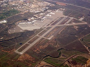
Marine Corps Air Station Miramar
USMC installation that is home to the 3rd Marine Aircraft Wing
Distance: Approx. 4034 meters
Latitude and longitude: 32.86777778,-117.14166667
Marine Corps Air Station Miramar (MCAS Miramar) (IATA: NKX, ICAO: KNKX, FAA LID: NKX) is a United States Marine Corps installation that is home to the 3rd Marine Aircraft Wing, which is the aviation element of the 1st Marine Expeditionary Force. It is located in Miramar, a community of San Diego, California, about 14 miles (23 km) north of downtown San Diego. The airfield has been named Mitscher Field since 1955, after Admiral M.A. Mitscher, who was the commander of Task Force 58 during World War II. The air station is the former location of Pacific Fleet fighter and Airborne Early Warning and Control aircraft (F-4 Phantom II, F-14 Tomcat, E-2 Hawkeye) and is best known as the former location of the United States Navy Fighter Weapons School (NFWS), its TOPGUN training program and the movie of the same name.

Miramar Air Show
San Diego air show
Distance: Approx. 4034 meters
Latitude and longitude: 32.86777778,-117.14166667
The Miramar Air Show is an annual air show in San Diego, California, held at Marine Corps Air Station Miramar. The three-day event is the largest military air show in the United States, with total annual attendance estimated at 700,000. In 2007, it was voted the "World's Best Military Air Show" by the International Council of Air Shows, the first time the award was given to a Marine Corps air station since 1994.

Tierrasanta, San Diego
Community of San Diego in California
Distance: Approx. 3202 meters
Latitude and longitude: 32.82083333,-117.09638889
Tierrasanta, Spanish for "holy land," or "holy ground", is a community in San Diego, California. The symbol of Tierrasanta is an encircled Conquistador cross, similar to one atop Montserrat mountain near Barcelona, Spain, though it no longer holds any religious meaning. The community is referred to as "The Island in the Hills" by locals and on welcome signs, as there are only four roads that lead to Tierrasanta, all which end within the community.

Montgomery-Gibbs Executive Airport
Airport in San Diego, California
Distance: Approx. 2305 meters
Latitude and longitude: 32.81583333,-117.13944444
Montgomery-Gibbs Executive Airport (IATA: MYF, ICAO: KMYF, FAA LID: MYF) is a public airport in San Diego, California, United States, six miles (10 km) north of downtown San Diego. The airport covers 456 acres (185 ha) and has three runways, one public helipad, and two private helipads. The runways are 28R/10L and 28L/10R (parallel) and 5/23.

Camp Kearny
U.S. military base in California
Distance: Approx. 4235 meters
Latitude and longitude: 32.8659831,-117.1030354
Camp Kearny was a U.S. military base (first Army, later Navy) in San Diego County, California, on the site of the current Marine Corps Air Station Miramar. It operated from 1917 to 1946. The base was named in honor of Brigadier General Stephen W. Kearny.

Kearny Mesa, San Diego
Community of San Diego in California
Distance: Approx. 1494 meters
Latitude and longitude: 32.825,-117.13916667
Kearny Mesa is a community in the central part of San Diego, California. It is bounded by State Route 52 to the north, Interstate 805 to the west, Aero Drive to the south, and Interstate 15 to the east. Adjacent communities include Serra Mesa, Clairemont and Tierrasanta.
Canyon Hills High School (San Diego)
Public school in California, United States
Distance: Approx. 2189 meters
Latitude and longitude: 32.82583333,-117.10555556
Canyon Hills High School is a public high school in the community of Tierrasanta in San Diego, California. Previously known as Junipero Serra High School, it was named for Junípero Serra, a Spanish missionary who founded Mission San Diego and other settlements in what is now California. It is a traditional school in the San Diego Unified School District and is the high school for students from Tierrasanta and the adjacent Murphy Canyon military housing community.
Western Sierra Law School
Distance: Approx. 3049 meters
Latitude and longitude: 32.81,-117.14333333
Western Sierra Law School (WSLS) is a private law school in Oceanside, California. The school was founded in 1979. It offers an affordable and accessible option to those looking to study the law, earn a Juris Doctor (J.D.) degree and qualify to sit for the California Bar Exam.

Coleman University
Private university in San Diego, California
Distance: Approx. 1574 meters
Latitude and longitude: 32.82166667,-117.13583333
Coleman University (1963–2018) was a private university in San Diego, California, focused on Information Technology education. Coleman had a technology-based curriculum with undergraduate, graduate, and distance education academic programs and was accredited by the Accrediting Council for Independent Colleges and Schools. The university closed on August 5, 2018.
Jewish Federation of San Diego County
Distance: Approx. 865 meters
Latitude and longitude: 32.8285657,-117.1200579
The Jewish Federation of San Diego County (officially United Jewish Federation of San Diego) is a 501(c)(3) nonprofit organization whose primary function is to broker fundraising and volunteer work in support of Jewish causes within the San Diego Jewish community. It also works in partnership with various affiliated organizations, who share a similar mission in supporting Jewish causes nationally and internationally, including the Jewish Federations of North America. The organization was incorporated on February 3, 1939.
Forbes School of Business & Technology
American online business school
Distance: Approx. 1573 meters
Latitude and longitude: 32.82722222,-117.14194444
The Forbes School of Business & Technology, also known as FSBT and Forbes Business School, is an online business school within The University of Arizona Global Campus. It offers degree programs at bachelor's and master's levels in business administration and information technology.
Minato School
Japanese weekend school in California, US
Distance: Approx. 710 meters
Latitude and longitude: 32.8389,-117.1314
The San Diego Japanese School (Japanese: サンディエゴ補習授業校, romanized: San Diego Hoshū Jugyō Kō), also known as Minato School (Japanese: みなと学園, romanized: Minato Gakuen), is a Japanese weekend school in San Diego, California. Classes are held at James Madison High School in Clairemont, while the school office is in another location in San Diego.
Weather in this IP's area
clear sky
21 Celsius
21 Celsius
19 Celsius
24 Celsius
1013 hPa
59 %
1013 hPa
997 hPa
10000 meters
5.66 m/s
230 degree
06:55:11
18:11:35