Country:
 USA
USARegion:
City:
Latitude and Longitude:
Time Zone:
Postal Code:
IP information under different IP Channel
ip-api
Country
Region
City
ASN
Time Zone
ISP
Blacklist
Proxy
Latitude
Longitude
Postal
Route
IPinfo
Country
Region
City
ASN
Time Zone
ISP
Blacklist
Proxy
Latitude
Longitude
Postal
Route
MaxMind
Country
Region
City
ASN
Time Zone
ISP
Blacklist
Proxy
Latitude
Longitude
Postal
Route
Luminati
Country
USRegion
tx
City
amarillo
ASN
Time Zone
America/Chicago
ISP
NTS-ONLINE
Latitude
Longitude
Postal
db-ip
Country
Region
City
ASN
Time Zone
ISP
Blacklist
Proxy
Latitude
Longitude
Postal
Route
ipdata
Country
Region
City
ASN
Time Zone
ISP
Blacklist
Proxy
Latitude
Longitude
Postal
Route
Popular places and events near this IP address

Amarillo College
Community college in Amarillo, Texas, U.S.
Distance: Approx. 4336 meters
Latitude and longitude: 35.188336,-101.847089
Amarillo College (AC) is a public community college in Amarillo, Texas. It enrolls over 9,100 students and was established in 1929 as Amarillo Junior College. Amarillo College has a total of six campuses as of August 2023.

Amarillo High School
Public school in the United States
Distance: Approx. 1771 meters
Latitude and longitude: 35.16661667,-101.90511111
Amarillo High School is a school located in the city of Amarillo, Texas, United States and is one of four high schools in the Amarillo Independent School District and classified as a 5A school by the University Interscholastic League (UIL). In 2015, the school was rated "Met Standard" by the Texas Education Agency.

Tascosa High School
Public school in Amarillo, Texas, United States
Distance: Approx. 3177 meters
Latitude and longitude: 35.19376389,-101.88082222
Tascosa High School is a public high school located in Amarillo, Texas (USA) and classified as a 5A school by the UIL. It is one of four high schools in the Amarillo Independent School District located in southern Potter County. The school was opened in 1958. In 2015, the school was rated "Met Standard" by the Texas Education Agency.
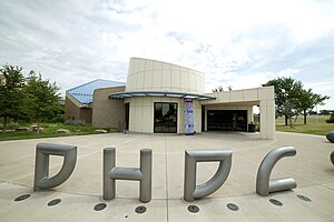
Don Harrington Discovery Center
Science museum in Amarillo, Texas
Distance: Approx. 4583 meters
Latitude and longitude: 35.199943,-101.913297
Don Harrington Discovery Center is a nonprofit interactive science center and planetarium in Amarillo, Texas, U.S. The Discovery Center is located in the city's hospital district and is named after philanthropist Don Harrington. Located in front of the Discovery Center is the Helium Centennial Time Columns Monument. The planetarium was renovated in 2003 and was implemented with the Digistar 3, fulldome video projection technology.
Western Crossing
Distance: Approx. 2691 meters
Latitude and longitude: 35.18944444,-101.88166667
Western Crossing, formerly known as Western Plaza, is a shopping mall in Amarillo, Texas, United States. It opened in 1968 with a construction cost of approximately US$13 million. Western Plaza was once a main shopping point in Amarillo, but from the 1980s to 2000s has suffered stores leaving its complex.
Holy Cross Catholic Academy (Amarillo, Texas)
Private, coeducational school in Amarillo, , Texas, United States
Distance: Approx. 2413 meters
Latitude and longitude: 35.17083333,-101.86
Holy Cross Catholic Academy is a private, Roman Catholic high school in Amarillo, Texas. It is the only Catholic high school in the Roman Catholic Diocese of Amarillo.

St. Andrew's Episcopal School (Amarillo, Texas)
Private school in Amarillo, Potter County, Texas, United States
Distance: Approx. 4040 meters
Latitude and longitude: 35.197988,-101.865908
St. Andrew's Episcopal School is a private school located in Amarillo, Texas, United States, providing education from primer to grade 8. The school was founded in 1951.

Amarillo Museum of Art
Distance: Approx. 4576 meters
Latitude and longitude: 35.18922,-101.844631
The Amarillo Museum of Art is located at 2200 S. Van Buren Street on the grounds of Amarillo College in the city of Amarillo, in the county of Potter, in the U.S. state of Texas.
Westgate Mall (Texas)
Shopping mall in Texas, United States
Distance: Approx. 4368 meters
Latitude and longitude: 35.18398,-101.92805
Westgate Mall is an indoor shopping mall located in Amarillo, Texas, United States. It has over 100 mainline stores and 3 anchor stores, two Dillard's locations, with the men's store originally a Mervyn's and the women’s store originally a Sears, JCPenney, with 1 vacant anchor last occupied by the former Dillard’s. The mall opened in October 1982 and cost $40 million to construct.

U.S. Route 66-Sixth Street Historic District
United States historic place
Distance: Approx. 5152 meters
Latitude and longitude: 35.21111111,-101.87611111
The US Route 66-Sixth Street Historic District is a historic district in Amarillo, Texas. The district is centered around the main section of the historic Route 66 in the San Jacinto Heights district of the city, which includes the Amarillo Natatorium. The district was added to the National Register of Historic Places on August 23, 1994.

Amarillo Globe Dream House
United States historic place
Distance: Approx. 4181 meters
Latitude and longitude: 35.18055556,-101.84361111
The Amarillo Globe Dream House is a historic house in Amarillo, Texas. The building was added to the National Register of Historic Places on December 8, 1997. The house also became a Recorded Texas Historic Landmark in 2008.

Amarillo Botanical Gardens
Botanical gardens in Amarillo, TX
Distance: Approx. 4417 meters
Latitude and longitude: 35.1972,-101.9149
The Amarillo Botanical Gardens (4.4 acres) includes botanical gardens and Mary E. Bivins Tropical conservatory. The gardens are located in Medical Center Park at 1400 Streit Drive, Amarillo, Texas. The gardens were established on November 17, 1968, after a number of years of fundraising.
Weather in this IP's area
clear sky
32 Celsius
31 Celsius
31 Celsius
33 Celsius
1010 hPa
36 %
1010 hPa
893 hPa
10000 meters
6.17 m/s
10.8 m/s
210 degree
07:31:33
19:53:02