206.248.98.86 - IP Lookup: Free IP Address Lookup, Postal Code Lookup, IP Location Lookup, IP ASN, Public IP
Country:
Region:
City:
Location:
Time Zone:
Postal Code:
IP information under different IP Channel
ip-api
Country
Region
City
ASN
Time Zone
ISP
Blacklist
Proxy
Latitude
Longitude
Postal
Route
Luminati
Country
City
bayamon
ASN
Time Zone
America/Puerto_Rico
ISP
LCPRL
Latitude
Longitude
Postal
IPinfo
Country
Region
City
ASN
Time Zone
ISP
Blacklist
Proxy
Latitude
Longitude
Postal
Route
IP2Location
206.248.98.86Country
Region
bayamon
City
bayamon
Time Zone
America/Puerto_Rico
ISP
Language
User-Agent
Latitude
Longitude
Postal
db-ip
Country
Region
City
ASN
Time Zone
ISP
Blacklist
Proxy
Latitude
Longitude
Postal
Route
ipdata
Country
Region
City
ASN
Time Zone
ISP
Blacklist
Proxy
Latitude
Longitude
Postal
Route
Popular places and events near this IP address

Bayamón City Hall
Building in Bayamón, Puerto Rico
Distance: Approx. 256 meters
Latitude and longitude: 18.396297,-66.155647
Bayamón City Hall is a building in Bayamón, Puerto Rico. As the name suggests, it serves as city hall to that city. It is named after Don Ángel Rivera Rodríguez, who was mayor of Bayamón from 1934 to 1944.

Juan Ramón Loubriel Stadium
Soccer stadium in Bayamón, Puerto Rico
Distance: Approx. 771 meters
Latitude and longitude: 18.393425,-66.15085
Juan Ramón Loubriel Stadium (Spanish: Estadio Juan Ramón Loubriel) is a soccer-specific stadium located in Bayamón, Puerto Rico. It is best known as the former home of the Puerto Rico Islanders of the North American Soccer League and current home of the Bayamón FC of the Liga Puerto Rico. The stadium can seat up to 12,500 people.

Coliseo Rubén Rodríguez
Multi-purpose arena in Bayamón, Puerto Rico
Distance: Approx. 655 meters
Latitude and longitude: 18.39495833,-66.15083333
Coliseo Rubén Rodríguez (English: Ruben Rodríguez Coliseum) is an indoor sporting arena in Puerto Rico. The coliseum was dedicated to Rubén Rodríguez (former player of the Vaqueros de Bayamón). It is located in Bayamón, Puerto Rico.
Farmacia Serra
United States historic place
Distance: Approx. 76 meters
Latitude and longitude: 18.399238,-66.155442
Farmacia Serra is a building close to the plaza of Bayamón, Puerto Rico which was built in 1910. It was listed on the National Register of Historic Places in 1989, and on the Puerto Rico Register of Historic Sites and Zones in 2000. It was the first in a chain of Serra drugstores eventually opened by Luis Serra.
Hondo River (Bayamón, Puerto Rico)
River of Puerto Rico
Distance: Approx. 476 meters
Latitude and longitude: 18.4024481,-66.1576669
The Río Hondo (Bayamón, Puerto Rico) is a river of Puerto Rico. The river lends its name to a neighborhood, the Rio Hondo neighborhood, or "Urbanizacion Rio Hondo", also in Bayamón, and to the neighborhood's mall, Plaza Rio Hondo (Plaza Rio Hondo).

Bayamón barrio-pueblo
Historical and administrative center (seat) of Bayamón, Puerto Rico
Distance: Approx. 462 meters
Latitude and longitude: 18.394672,-66.15429
Bayamón is a barrio and the administrative center (seat) of Bayamón, a municipality of Puerto Rico. Its population in 2010 was 4,746. As was customary in Spain, in Puerto Rico, the municipality has a barrio called pueblo which contains a central plaza, the municipal buildings (city hall), and a Catholic church.

Dr. Agustín Stahl Stamm House
Historic residence in Bayamón, Puerto Rico
Distance: Approx. 57 meters
Latitude and longitude: 18.398781,-66.1552
The Dr. Agustín Stahl Stamm House (Spanish: Casa Dr. Agustín Stahl Stamm) is a historic residence in Bayamón, Puerto Rico.

José Celso Barbosa House Museum
Historic house in Bayamón, Puerto Rico
Distance: Approx. 138 meters
Latitude and longitude: 18.399036,-66.15448
The José Celso Barbosa House Museum (Spanish: Casa Museo José Celso Barbosa) is a historic house museum in Bayamón municipality, Puerto Rico. The house was added to the U.S. National Register of Historic Places in 1984, under the name Casa Natal Dr. José Celso Barbosa (English: Dr.

Bayamón station
Rail station of the Tren Urbano system in San Juan, Puerto Rico
Distance: Approx. 247 meters
Latitude and longitude: 18.4,-66.15388889
Bayamón is a rapid transit station in the San Juan agglomeration, Puerto Rico. It is the western terminus of the Tren Urbano system, located after Deportivo station. The station is located in Bayamón, just outside of its downtown (Bayamón Pueblo).

Invención de la Santa Cruz Parish
Church located in Bayamón, Puerto Rico
Distance: Approx. 462 meters
Latitude and longitude: 18.394672,-66.15429
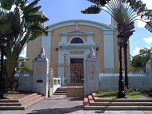
Invención de la Santa Cruz (Spanish for Invention of the Holy Cross) is a historic Catholic parish church located in Bayamón Pueblo, the historic and administrative downtown area of Bayamón, Puerto Rico. The church is located on the Plaza de Hostos, the main town square of Bayamón, at 12 Degetau Street, in front of the former city hall and current Francisco Oller Museum building. The establishment of the current church dates to 1750 when construction of the structure began with plans to move the main Catholic parish of the area from its former location next to Hacienda Santa Cruz to the current location, then known as Alto del Embarcadero, a small hill located close to the Bayamón River.

Marqués de la Serna Bridge
United States historic place
Distance: Approx. 465 meters
Latitude and longitude: 18.40277778,-66.15583333
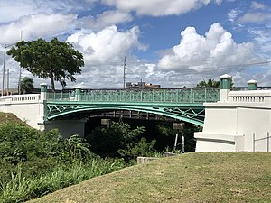
Marqués de la Serna Bridge (Spanish: Puente Marqués de la Serna), also known as Bayamón Bridge (Puente de Bayamón) and Bridge #379, is a historic rolled iron segmented arch bridge that crosses the Bayamón River, located between the barrios of Bayamón Pueblo and Juan Sánchez in the Puerto Rican municipality of Bayamón. Its lowered arches, similar to those of the Pont d'Arcole in Paris, are unique in Puerto Rico. The bridge was added to the United States National Register of Historic Places on July 19, 1995, and to the Puerto Rico Register of Historic Sites and Zones in 2000.

El Cantón Mall
Shopping mall in Bayamón, Puerto Rico
Distance: Approx. 309 meters
Latitude and longitude: 18.40111111,-66.15694444
El Cantón Mall is an enclosed shopping mall in Bayamón, Puerto Rico. It houses stores such as Rent-A-Center, Rainbow, Grand Way, Donato, All Ways 99, Claro, T-Mobile, La Gloría, Me Salvé, and many others. The mall was formerly anchored by Tiendas Capri, which left in 2017 and was later replaced with government offices.
Weather in this IP's area
heavy intensity rain
24 Celsius
25 Celsius
22 Celsius
24 Celsius
1015 hPa
95 %
1015 hPa
996 hPa
10000 meters
0.45 m/s
0.45 m/s
105 degree
13 %