Country:
 Benin
BeninRegion:
City:
Latitude and Longitude:
Time Zone:
Postal Code:
IP information under different IP Channel
ip-api
Country
Region
City
ASN
Time Zone
ISP
Blacklist
Proxy
Latitude
Longitude
Postal
Route
IPinfo
Country
Region
City
ASN
Time Zone
ISP
Blacklist
Proxy
Latitude
Longitude
Postal
Route
MaxMind
Country
Region
City
ASN
Time Zone
ISP
Blacklist
Proxy
Latitude
Longitude
Postal
Route
Luminati
Country
 US
USASN
Time Zone
America/Chicago
ISP
LLNW
Latitude
Longitude
Postal
db-ip
Country
Region
City
ASN
Time Zone
ISP
Blacklist
Proxy
Latitude
Longitude
Postal
Route
ipdata
Country
Region
City
ASN
Time Zone
ISP
Blacklist
Proxy
Latitude
Longitude
Postal
Route
Popular places and events near this IP address

Atakora Department
Department of Benin
Distance: Approx. 494 meters
Latitude and longitude: 10.3,1.38333333
Atakora [a.ta.kɔ.ʁa] (also spelled Atacora, named for the Atakora Mountains) is the northwesternmost department of Benin. Externally it borders Togo to the west and Burkina Faso to the north; internally it borders the departments of Alibori, Borgou and Donga. Major towns in the Atakora include Natitingou and Tanguiéta, and the major tourist areas include the Tata Somba houses, Pendjari National Park, and various waterfalls.
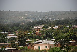
Natitingou
Commune and city in Atakora Department, Benin
Distance: Approx. 1587 meters
Latitude and longitude: 10.3,1.36666667
Natitingou [na.ti.tɛ̃ŋ.gu], informally referred to as Nati [na.ti], is a city and commune in north western Benin and the capital of Atakora Department. The commune covers an area of 3045 square kilometres and as of 2013 had a population of 104,010 people. Natitingou, like many areas of Benin, is home to a constituent monarchy.
Roman Catholic Diocese of Natitingou
Roman Catholic diocese in Benin
Distance: Approx. 1587 meters
Latitude and longitude: 10.3,1.36666667
The Roman Catholic Diocese of Natitingou (Latin: Dioecesis Natitinguensis) is a Latin Church diocese of the Catholic Church, located in the city of Natitingou in the ecclesiastical province of Cotonou in Benin.
Boundétingou Airport
Airport in Benin
Distance: Approx. 9238 meters
Latitude and longitude: 10.37697222,1.3605
Boundétingou Airport (IATA: NAE, ICAO: DBBN) is a public use airport located near Natitingou, Atakora, Benin.
Natitingou I
Urban Arrondissement in Atakora Department, Benin
Distance: Approx. 1584 meters
Latitude and longitude: 10.3,1.3667
Natitingou I is an arrondissement in the Atakora Department of northwestern Benin. It is an administrative division under the jurisdiction of the commune of Natitingou, and makes up part of the urban area. According to the population census conducted by the Institut National de la Statistique Benin on February 15, 2002, the arrondissement had a total population of 10,012.
Natitingou II
Urban Arrondissement in Atakora Department, Benin
Distance: Approx. 1584 meters
Latitude and longitude: 10.3,1.3667
Natitingou II is an arrondissement in the Atakora Department of northwestern Benin. It is an administrative division under the jurisdiction of the commune of Natitingou, and makes up part of the urban area. According to the population census conducted by the Institut National de la Statistique Benin on February 15, 2002, the arrondissement had a total population of 10,458.
Natitingou III
Urban Arrondissement in Atakora Department, Benin
Distance: Approx. 1584 meters
Latitude and longitude: 10.3,1.3667
Natitingou III is an arrondissement in the Atakora Department of northwestern Benin. It is an administrative division under the jurisdiction of the commune of Natitingou, and makes up part of the urban area. According to the population census conducted by the Institut National de la Statistique Benin on February 15, 2002, the arrondissement had a total population of 14,559.
Natitingou IV
Urban Arrondissement in Atakora Department, Benin
Distance: Approx. 1584 meters
Latitude and longitude: 10.3,1.3667
Natitingou IV or Péporiyakou is an arrondissement in the Atakora Department of northwestern Benin. It is an administrative division under the jurisdiction of the commune of Natitingou, and makes up part of the urban area. According to the population census conducted by the Institut National de la Statistique Benin on February 15, 2002, the arrondissement had a total population of 5,414.
Koundata
Arrondissement and town in Atakora Department, Benin
Distance: Approx. 5387 meters
Latitude and longitude: 10.28333333,1.33333333
Koundata is a town and arrondissement in the Atakora Department of northwestern Benin. It is an administrative division under the jurisdiction of the commune of Natitingou. According to the population census conducted by the Institut National de la Statistique Benin on February 15, 2002, the arrondissement had a total population of 3,590.
Weather in this IP's area
overcast clouds
21 Celsius
22 Celsius
21 Celsius
21 Celsius
1013 hPa
96 %
1013 hPa
964 hPa
10000 meters
1.23 m/s
1.36 m/s
140 degree
98 %
06:43:59
18:53:13