Country:
 USA
USARegion:
City:
Latitude and Longitude:
Time Zone:
Postal Code:
IP information under different IP Channel
ip-api
Country
Region
City
ASN
Time Zone
ISP
Blacklist
Proxy
Latitude
Longitude
Postal
Route
IPinfo
Country
Region
City
ASN
Time Zone
ISP
Blacklist
Proxy
Latitude
Longitude
Postal
Route
MaxMind
Country
Region
City
ASN
Time Zone
ISP
Blacklist
Proxy
Latitude
Longitude
Postal
Route
Luminati
Country
USASN
Time Zone
America/Chicago
ISP
SYNOPTEK
Latitude
Longitude
Postal
db-ip
Country
Region
City
ASN
Time Zone
ISP
Blacklist
Proxy
Latitude
Longitude
Postal
Route
ipdata
Country
Region
City
ASN
Time Zone
ISP
Blacklist
Proxy
Latitude
Longitude
Postal
Route
Popular places and events near this IP address

81st Street–Museum of Natural History station
New York City Subway station in Manhattan
Distance: Approx. 132 meters
Latitude and longitude: 40.781971,-73.971763
The 81st Street–Museum of Natural History station is a local station on the IND Eighth Avenue Line of the New York City Subway. It is served by the B on weekdays, the C train at all times except nights, and the A train during late nights only.
Seneca Village
Former settlement in Manhattan, New York
Distance: Approx. 226 meters
Latitude and longitude: 40.784002,-73.968892
Seneca Village was a 19th-century settlement of mostly African American landowners in the borough of Manhattan in New York City, within what would become present-day Central Park. The settlement was located near the current Upper West Side neighborhood, approximately bounded by Central Park West and the axes of 82nd Street, 89th Street, and Seventh Avenue, had they been constructed through the park. Seneca Village was founded in 1825 by free Black Americans, the first such community in the city, although under Dutch rule there was a "half-free" community of African-owned farms north of New Amsterdam.

Rose Center for Earth and Space
Part of the American Museum of Natural History
Distance: Approx. 239 meters
Latitude and longitude: 40.78153611,-73.97324722
The Rose Center for Earth and Space is a part of the American Museum of Natural History in New York City. The Center's complete name is The Frederick Phineas and Sandra Priest Rose Center for Earth and Space. The main entrance is located on the northern side of the museum on 81st Street near Central Park West in Manhattan's Upper West Side.

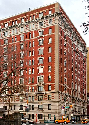
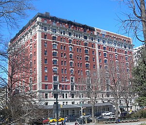
The Beresford
Residential skyscraper in Manhattan, New York
Distance: Approx. 86 meters
Latitude and longitude: 40.7825,-73.97194444
The Beresford is a cooperative apartment building at 211 Central Park West, between 81st and 82nd Streets, on the Upper West Side of Manhattan in New York City. It was constructed in 1929 and was designed by architect Emery Roth. The Beresford is 22 stories tall and is topped by octagonal towers on its northeast, southwest, and southeast corners.

Diana Ross Playground
Playground in Central Park, New York City
Distance: Approx. 96 meters
Latitude and longitude: 40.7822725,-73.97097429
The Diana Ross Playground is located in New York City's Central Park, inside the park at West 81st Street and Central Park West.

Central Park West Historic District
Historic district in Manhattan, New York
Distance: Approx. 216 meters
Latitude and longitude: 40.78444444,-73.96944444
The Central Park West Historic District is located along Central Park West, between 61st and 97th Streets, on the Upper West Side of Manhattan in New York City, United States. The district was added to the National Register of Historic Places on November 9, 1982. The district encompasses a portion of the Upper West Side-Central Park West Historic District as designated by the New York City Landmarks Preservation Commission, and contains a number of prominent New York City designated landmarks, including the Dakota, a National Historic Landmark.

A Photographer's Gallery
Distance: Approx. 227 meters
Latitude and longitude: 40.78513,-73.97152
A Photographer's Gallery (March 1955 – 1957), 48 West 85th Street, on the Upper West Side of Manhattan in New York City, founded and opened by Roy DeCarava, was an early effort to gain recognition for photography as an art form. It exhibited art photography intended for walls in homes, and offices, along with paintings.

Congregation Rodeph Sholom (Manhattan)
Reform synagogue in New York City
Distance: Approx. 93 meters
Latitude and longitude: 40.78388889,-73.97166667
Congregation Rodeph Sholom is a Reform Jewish synagogue at 7 West 83rd Street on the Upper West Side of Manhattan in New York City, New York. Founded in 1842 by German Jewish immigrants, it is one of the oldest synagogues in the United States.
81st Street station (IRT Ninth Avenue Line)
Former Manhattan Railway elevated station (closed 1940)
Distance: Approx. 273 meters
Latitude and longitude: 40.78324167,-73.97453056
The 81st Street station was a local station on the demolished IRT Ninth Avenue Line in Manhattan, New York City. It had two levels. The lower level was built first and had two tracks and two side platforms and served local trains.
257 Central Park West
Co-op apartment building in Manhattan, New York
Distance: Approx. 250 meters
Latitude and longitude: 40.785,-73.96972222
257 Central Park West (also known as the Orwell House) is a co-op apartment building on the southwest corner of 86th Street and Central Park West in the Upper West Side of Manhattan in New York City. It was designed by the firm of Mulliken and Moeller and built by Gotham Building & Construction between 1905 and 1906. The structure was constructed as a luxury apartment house originally called the Central Park View.
Rossleigh Court
Apartment building in Manhattan, New York
Distance: Approx. 211 meters
Latitude and longitude: 40.78472222,-73.97
Rossleigh Court, constructed between 1906 and 1907, currently is a rental apartment building located on the northwest corner of 85th Street and Central Park West in the Upper West Side of Manhattan in New York City. Like the similarly designed and adjoining building to its north, 257 Central Park West, Rossleigh Court was designed by Mulliken and Moeller and built by Gotham Building and Construction. Opening one year after its "twin" to the north, both buildings followed the popular "French Flat" model in a Beaux-Arts style.
Eighty One
Defunct restaurant in New York City, U.S.
Distance: Approx. 218 meters
Latitude and longitude: 40.78313889,-73.97388889
Eighty One was a restaurant in New York City. The restaurant had received a Michelin star, before closing.
Weather in this IP's area
clear sky
17 Celsius
16 Celsius
13 Celsius
19 Celsius
1021 hPa
57 %
1021 hPa
1017 hPa
10000 meters
4.12 m/s
10 degree
06:56:50
18:31:12