206.201.156.129 - IP Lookup: Free IP Address Lookup, Postal Code Lookup, IP Location Lookup, IP ASN, Public IP
Country:
Region:
City:
Location:
Time Zone:
Postal Code:
IP information under different IP Channel
ip-api
Country
Region
City
ASN
Time Zone
ISP
Blacklist
Proxy
Latitude
Longitude
Postal
Route
Luminati
Country
Region
mi
City
grandblanc
ASN
Time Zone
America/Detroit
ISP
CMCS
Latitude
Longitude
Postal
IPinfo
Country
Region
City
ASN
Time Zone
ISP
Blacklist
Proxy
Latitude
Longitude
Postal
Route
IP2Location
206.201.156.129Country
Region
michigan
City
flint
Time Zone
America/Detroit
ISP
Language
User-Agent
Latitude
Longitude
Postal
db-ip
Country
Region
City
ASN
Time Zone
ISP
Blacklist
Proxy
Latitude
Longitude
Postal
Route
ipdata
Country
Region
City
ASN
Time Zone
ISP
Blacklist
Proxy
Latitude
Longitude
Postal
Route
Popular places and events near this IP address

Genesee Towers
Office , Parking in Michigan, United States
Distance: Approx. 207 meters
Latitude and longitude: 43.01614,-83.68972
The Genesee Towers was the tallest building in Flint, Michigan, United States. It was demolished on December 22, 2013 after a period of inactivity and loss of occupancy.

Flint Local 432
Flint, Michigan music venue
Distance: Approx. 206 meters
Latitude and longitude: 43.01561111,-83.69188889
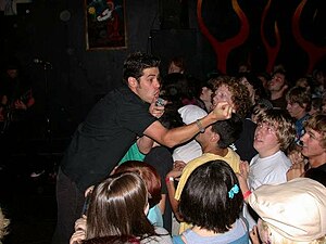
The Flint Local 432 (or "the Local") is a non-profit 501(c)(3), all-ages, substance free music venue located in downtown Flint, Michigan. The Local's name is a reference to the autoworker unions located in the area. It was founded in the mid-1980s by Joel Rash, for the purpose of providing the Flint area with an all-ages venue for local and national bands to play that was focused on the music.

Elks Lodge Building (Flint, Michigan)
United States historic place
Distance: Approx. 94 meters
Latitude and longitude: 43.01388889,-83.69111111
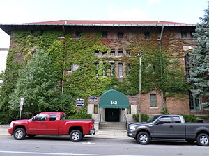
The Elks Lodge Building in Flint, Michigan, also known as Old Elks Building, was built in 1913. It was listed on the National Register of Historic Places in 1978.

The Paterson Building
Distance: Approx. 98 meters
Latitude and longitude: 43.0144,-83.6889
The Paterson Building is a historic structure located at 653 South Saginaw Street and Third Street in Flint, Michigan. It was built by William A. Paterson of the W. A. Paterson Company who first built carriages there starting in 1869. He switched to manufacturing automobiles in 1909, and the company built well-regarded automobiles until 1923.

Capitol Theatre Building (Flint, Michigan)
United States historic place
Distance: Approx. 151 meters
Latitude and longitude: 43.0153,-83.68885
The Capitol Theatre Building is a cinema and concert venue located at 140 E. 2nd St. in Flint, Michigan. Designed by John Eberson, it is an atmospheric theater designed to look like a Roman garden.

William A. Paterson Factory Complex
United States historic place
Distance: Approx. 167 meters
Latitude and longitude: 43.01416667,-83.68805556
The William A. Paterson Factory Complex was a factory located at 126 East 3rd Street in Flint, Michigan. It was listed on the National Register of Historic Places in 1984. The building was demolished in 1996.
Genesee County Courthouse (Michigan)
United States historic place
Distance: Approx. 337 meters
Latitude and longitude: 43.01166667,-83.68805556
The Genesee County Courthouse is a government building located at 920 South Saginaw Street in Flint, Michigan. It was listed on the National Register of Historic Places in 1990.

First Street Lofts
United States historic place
Distance: Approx. 189 meters
Latitude and longitude: 43.01583333,-83.69111111
The First Street Lofts (formerly the First National Bank and Trust Company Building) is a converted office building located at 460 South Saginaw Street in Flint, Michigan. It was listed on the National Register of Historic Places in 2007.

Federal Building (Flint, Michigan)
United States historic place
Distance: Approx. 204 meters
Latitude and longitude: 43.01333333,-83.69222222
The Federal Building (also known as the United States Post Office) is a US government office building located at 600 Church Street in Flint, Michigan. It was listed on the National Register of Historic Places in 2013.

Flint Journal Building
United States historic place
Distance: Approx. 253 meters
Latitude and longitude: 43.01638889,-83.68888889
The Flint Journal Building is an office building located at 200 East First Street in Flint, Michigan. It was listed on the National Register of Historic Places in 2013. It is now used by the Michigan State University College of Human Medicine.

Charles Stewart Mott Foundation Building
High rise building in Flint, Michigan
Distance: Approx. 186 meters
Latitude and longitude: 43.01597222,-83.69022222
The Charles Stewart Mott Foundation Building (formerly the Union Industrial Bank Building) is a 16-story office high-rise building in downtown Flint, Michigan. It is the tallest building in the city. Designed by Wirt C. Rowland in 1928 and opened in 1930, it was built as the Union Industrial Bank Building to serve as the headquarters for Union Industrial Bank.

City of Flint Municipal Center
Government office complex in Michigan, US
Distance: Approx. 253 meters
Latitude and longitude: 43.01638889,-83.68888889
The City of Flint Municipal Center is a complex of seven government office buildings located at 1101 Saginaw Street, 210 East Fifth Street, 310 East Fifth Street in Flint, Michigan. The area was listed on the National Register of Historic Places in 2019.
Weather in this IP's area
broken clouds
-1 Celsius
-4 Celsius
-1 Celsius
-1 Celsius
1013 hPa
69 %
1013 hPa
982 hPa
10000 meters
2.57 m/s
240 degree
75 %
