Country:
 USA
USARegion:
City:
Latitude and Longitude:
Time Zone:
Postal Code:
IP information under different IP Channel
ip-api
Country
Region
City
ASN
Time Zone
ISP
Blacklist
Proxy
Latitude
Longitude
Postal
Route
IPinfo
Country
Region
City
ASN
Time Zone
ISP
Blacklist
Proxy
Latitude
Longitude
Postal
Route
MaxMind
Country
Region
City
ASN
Time Zone
ISP
Blacklist
Proxy
Latitude
Longitude
Postal
Route
Luminati
Country
USRegion
or
City
florence
ASN
Time Zone
America/Los_Angeles
ISP
AS-WAVE-1
Latitude
Longitude
Postal
db-ip
Country
Region
City
ASN
Time Zone
ISP
Blacklist
Proxy
Latitude
Longitude
Postal
Route
ipdata
Country
Region
City
ASN
Time Zone
ISP
Blacklist
Proxy
Latitude
Longitude
Postal
Route
Popular places and events near this IP address
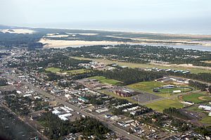
Florence, Oregon
City in Oregon, United States
Distance: Approx. 1230 meters
Latitude and longitude: 43.99166667,-124.10833333
Florence is a coastal city in Lane County, in the U.S. state of Oregon. It lies at the mouth of the Siuslaw River on the Pacific Ocean and about midway between Newport to the north and Coos Bay to the south along U.S. Route 101. As of August 14, 2023, the city had a total population of 9,553.
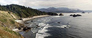
Oregon Coast
Coastal region of the U.S. state of Oregon
Distance: Approx. 1148 meters
Latitude and longitude: 44,-124.1
The Oregon Coast is a coastal region of the U.S. state of Oregon. It is bordered by the Pacific Ocean to its west and the Oregon Coast Range to the east, and stretches approximately 362 miles (583 km) from the California state border in the south to the Columbia River in the north. The region is not a specific geological, environmental, or political entity, and includes the Columbia River Estuary.

Florence Municipal Airport
Airport in Florence, Oregon
Distance: Approx. 1730 meters
Latitude and longitude: 43.98281667,-124.11136944
Florence Municipal Airport (IATA: FMU, FAA LID: 6S2), is a public airport located in the city of Florence in Lane County, Oregon, United States. It is mostly used for general aviation.
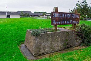
Siuslaw High School
High school in Oregon
Distance: Approx. 1047 meters
Latitude and longitude: 43.992,-124.106
Siuslaw High School is a public high school in the northwest United States, located in Florence, Oregon. It is named after the local Siuslaw River, and the current principal is Michael Harklerode.
Glenada, Oregon
Unincorporated community in the state of Oregon, United States
Distance: Approx. 3478 meters
Latitude and longitude: 43.96055556,-124.10277778
Glenada is an unincorporated community in Lane County, Oregon, United States, across the Siuslaw River from the city of Florence on U.S. Route 101.
Peace Harbor Hospital
Hospital in Oregon, United States
Distance: Approx. 2702 meters
Latitude and longitude: 43.9752,-124.1186
Peace Harbor Hospital is a 21-bed acute care facility and a Level IV Trauma Center. It is located in Florence, Oregon, and serves western Lane County, Oregon.
Sandpines Golf Links
Public golf course in Oregon, United States
Distance: Approx. 1858 meters
Latitude and longitude: 44.00277778,-124.10944444
Sandpines Golf Links is a public golf course in Florence, Oregon, United States, on the central Oregon Coast.

Ocean Dunes High School
Public school in Florence, , Oregon, United States
Distance: Approx. 4220 meters
Latitude and longitude: 43.955562,-124.111691
Ocean Dunes High School is a public high school in Florence, Oregon, United States. It is located at Camp Florence, operated by the Oregon Youth Authority.
Cushman, Oregon
Unincorporated community in the state of Oregon, United States
Distance: Approx. 3958 meters
Latitude and longitude: 43.98555556,-124.04416667
Cushman is an unincorporated community in Lane County, Oregon, United States. It is located on the north bank of the Siuslaw River on Oregon Route 126, between Tiernan and Florence. Cushman was a station on the Coos Bay Branch of the Southern Pacific Railroad (today the Coos Bay Rail Link), named for local residents C. C. and I. B. Cushman.

Edwin E. Benedict House
Historic house in Oregon, United States
Distance: Approx. 2716 meters
Latitude and longitude: 43.975279,-124.067069
The Edwin E. Benedict House was a historic house located on Cox Island in the Siuslaw River, near Florence, Oregon, United States. The house was listed on the National Register of Historic Places in 1979.

North Fork Siuslaw River
River in Oregon, the United States of America
Distance: Approx. 1896 meters
Latitude and longitude: 43.97638889,-124.08083333
The North Fork Siuslaw River is a tributary of the Siuslaw River in Lane County in the United States state of Oregon. It is formed by the confluence of Sam Creek and West Branch in the Siuslaw National Forest of the Central Oregon Coast Range. The former community of Pawn was once at the juncture of the two creeks.
Siuslaw Pioneer Museum
American history museum
Distance: Approx. 2730 meters
Latitude and longitude: 43.96832,-124.10596
The Siuslaw Pioneer Museum documents the local history of the Siuslaw Region and Florence, Oregon, from times of indigenous peoples preceding White settlement in the late 1800's to the present.
Weather in this IP's area
clear sky
8 Celsius
7 Celsius
8 Celsius
10 Celsius
1021 hPa
48 %
1021 hPa
1019 hPa
10000 meters
2.75 m/s
2.97 m/s
78 degree
1 %
07:19:19
18:49:37