206.168.85.128 - IP Lookup: Free IP Address Lookup, Postal Code Lookup, IP Location Lookup, IP ASN, Public IP
Country:
 USA
USARegion:
City:
Location:
Time Zone:
Postal Code:
ISP:
ASN:
language:
User-Agent:
Proxy IP:
Blacklist:
IP information under different IP Channel
ip-api
Country
Region
City
ASN
Time Zone
ISP
Blacklist
Proxy
Latitude
Longitude
Postal
Route
db-ip
Country
Region
City
ASN
Time Zone
ISP
Blacklist
Proxy
Latitude
Longitude
Postal
Route
IPinfo
Country
Region
City
ASN
Time Zone
ISP
Blacklist
Proxy
Latitude
Longitude
Postal
Route
IP2Location
206.168.85.128Country
usRegion
alaska
City
dutch harbor
Time Zone
America/Adak
ISP
Language
User-Agent
Latitude
Longitude
Postal
ipdata
Country
Region
City
ASN
Time Zone
ISP
Blacklist
Proxy
Latitude
Longitude
Postal
Route
Popular places and events near this IP address
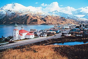
Unalaska, Alaska
Town in Alaska
Distance: Approx. 1006 meters
Latitude and longitude: 53.88888889,-166.52722222
The City of Unalaska (Aleut: Iluulux̂; Russian: Уналашка) is the main population center in the Aleutian Islands. The city is in the Aleutians West Census Area, a regional component of the Unorganized Borough in the U.S. state of Alaska. Unalaska is located on Unalaska Island and neighboring Amaknak Island in the Aleutian Islands off mainland Alaska.
Dutch Harbor
Harbor in the United States
Distance: Approx. 2662 meters
Latitude and longitude: 53.90291667,-166.51838889
Dutch Harbor is a harbor on Amaknak Island in Unalaska, Alaska. It was the location of the Battle of Dutch Harbor in June, 1942 when the Imperial Japanese Navy attacked it just seven months after the attack on Pearl Harbor in Hawaii. To this day, it remains one of the few sites in the United States to be subjected to an aerial bombardment by a foreign power.

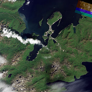
Amaknak Island
Most populous of the Aleutian Islands, Alaska, United States
Distance: Approx. 3399 meters
Latitude and longitude: 53.91027778,-166.53666667
Amaknak Island (Russian: Амакнак) or Umaknak Island (Aleut: Amaxnax̂; Russian: Умакнак) is the most populated island in the Aleutian Islands, an archipelago which is part of the U.S. state of Alaska.
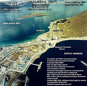
Unalaska Airport
Airport in Amaknak Island
Distance: Approx. 2322 meters
Latitude and longitude: 53.89888889,-166.545
Tom Madsen (Dutch Harbor) Airport (IATA: DUT, ICAO: PADU, FAA LID: DUT) is a state-owned public-use airport in City of Unalaska, on Amaknak Island in the Aleutian Islands, off the coast of the U.S. state of Alaska. It is located near the Bering Sea coast of Unalaska Island, 800 miles (1,300 km) southwest of Anchorage and 1,950 miles (3,140 km) from Seattle. The official name of the City of Unalaska's port is Dutch Harbor.

Aleutian World War II National Historic Area
Distance: Approx. 1006 meters
Latitude and longitude: 53.88888889,-166.52722222
The Aleutian World War II National Historic Area is a U.S. National Historic Site on Amaknak Island in the Aleutian Island Chain of Alaska. It offers visitors a glimpse of both natural and cultural history, and traces the historic footprints of the U.S. Army Base, Fort Schwatka, located at the Ulakta Head on Mount Ballyhoo. The fort, 800 miles west of Anchorage, the nearest large urban center, was one of four coastal defense posts built to protect Dutch Harbor (crucial back door to the United States) during World War II; Fort Schwatka is also the highest coastal battery ever constructed in the United States.
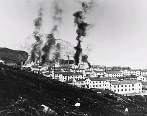
Battle of Dutch Harbor
1942 aerial bombing of a U.S. Army base on Amaknak Island, Alaska by the Japanese Navy
Distance: Approx. 1158 meters
Latitude and longitude: 53.8875,-166.54222222
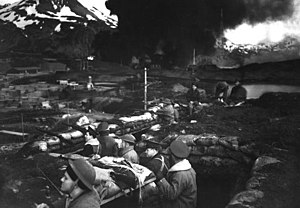
The Battle of Dutch Harbor took place on 3-4 June 1942, when the Imperial Japanese Navy launched two aircraft carrier raids on the Dutch Harbor Naval Operating Base and U.S. Army Fort Mears at Dutch Harbor on Amaknak Island, opening the Aleutian Islands campaign of World War II. The bombing marked the first aerial attack by an enemy on the continental United States and was the second time in history that the continental U.S. was bombed by someone working for a foreign power, the first being the accidental bombing of Naco, Arizona, in 1929.

Church of the Holy Ascension
Historic church in Alaska, United States
Distance: Approx. 649 meters
Latitude and longitude: 53.87555556,-166.53638889
The Church of the Holy Ascension (Russian: Церковь Вознесения Господня), also known as the Holy Ascension Orthodox Church, is a prominent landmark in Unalaska, the major community of the western Aleutian Islands in southwestern Alaska. The current church was built in 1894, probably on the site of an 1826 church, and likely using timbers and other elements (including one iconostasis) from the older church. It is one of the oldest churches in Alaska, and is significant as the site from which missionaries brought their religion to the local Aleut people.

Sitka Spruce Park
United States historic place
Distance: Approx. 1305 meters
Latitude and longitude: 53.88805556,-166.54444444
Sitka Spruce Park is a public park in the city of Unalaska, Alaska. The roughly 5-acre (2.0 ha) park is located on Biorka Drive on Amaknak Island, south of Unalaska Airport. It is one of the few places on the island where there are a significant number of trees.
Dutch Harbor Naval Operating Base and Fort Mears, U.S. Army
United States historic place
Distance: Approx. 1191 meters
Latitude and longitude: 53.88805556,-166.54194444
The Dutch Harbor Naval Operating Base and Fort Mears were the two military installations built next to each other in Dutch Harbor, on Amaknak Island of the Aleutian Islands in Alaska, by the United States in response to the growing war threat with Imperial Japan during World War II. In 1938, the Navy Board recommended the construction which began in July 1940. The first United States Army troops arrived in June 1941 and an air base constructed by the United States Navy was finished in September 1941. At the time of the surprise attack on Pearl Harbor, these were the only military installations in the Aleutian Islands.

PenAir Flight 3296
2019 aviation accident
Distance: Approx. 1630 meters
Latitude and longitude: 53.894,-166.5373
PenAir Flight 3296 (marketed as Alaska Airlines Flight 3296 under a codeshare agreement with Alaska Airlines) was a domestic scheduled flight from Ted Stevens Anchorage International Airport in Anchorage, Alaska, to Unalaska Airport on Amaknak Island in the Aleutian Chain of Alaska. On October 17, 2019, the Saab 2000 operating the flight overran the runway after landing at its destination airport. Of the 42 passengers and crew on board, one passenger (identified as David Allan Oltman) was fatally injured when a propeller blade penetrated the fuselage, one was seriously injured and ten suffered minor injuries.

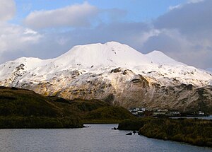
Mount Ballyhoo
Mountain in Alaska, United States
Distance: Approx. 3804 meters
Latitude and longitude: 53.9141729,-166.5303972
Mount Ballyhoo is a 1,650-foot-elevation (503-meter) summit in Alaska, United States.
Mount Newhall
Summit in Alaska, United States
Distance: Approx. 3141 meters
Latitude and longitude: 53.8730556,-166.4836111
Mount Newhall is a 1,916-foot-elevation (584-meter) summit in Alaska, United States.
Weather in this IP's area
mist
6 Celsius
2 Celsius
6 Celsius
6 Celsius
1026 hPa
81 %
1026 hPa
1026 hPa
8047 meters
7.2 m/s
12.35 m/s
120 degree
100 %