Country:
 USA
USARegion:
City:
Latitude and Longitude:
Time Zone:
Postal Code:
IP information under different IP Channel
ip-api
Country
Region
City
ASN
Time Zone
ISP
Blacklist
Proxy
Latitude
Longitude
Postal
Route
IPinfo
Country
Region
City
ASN
Time Zone
ISP
Blacklist
Proxy
Latitude
Longitude
Postal
Route
MaxMind
Country
Region
City
ASN
Time Zone
ISP
Blacklist
Proxy
Latitude
Longitude
Postal
Route
Luminati
Country
USASN
Time Zone
America/Chicago
ISP
Afr-ix Telecom Sau
Latitude
Longitude
Postal
db-ip
Country
Region
City
ASN
Time Zone
ISP
Blacklist
Proxy
Latitude
Longitude
Postal
Route
ipdata
Country
Region
City
ASN
Time Zone
ISP
Blacklist
Proxy
Latitude
Longitude
Postal
Route
Popular places and events near this IP address
Elmhurst, Delaware
Unincorporated community in Delaware, United States
Distance: Approx. 994 meters
Latitude and longitude: 39.73055556,-75.59
Elmhurst is an unincorporated community in New Castle County, Delaware, United States. It was founded in the late 1910s and consists of about 500 houses.
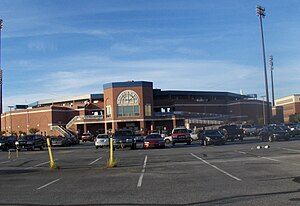
Daniel S. Frawley Stadium
Stadium in Wilmington, Delaware, US
Distance: Approx. 1204 meters
Latitude and longitude: 39.73222222,-75.56444444
Daniel S. Frawley Stadium is a stadium in Wilmington, Delaware. It is primarily used for baseball, and is the home field of the Wilmington Blue Rocks minor league baseball team. The park was originally known as Legends Stadium when it was built in 1993.

St. Elizabeth High School (Delaware)
Private, coeducational school in Wilmington, Delaware, United States
Distance: Approx. 851 meters
Latitude and longitude: 39.73833333,-75.57333333
St. Elizabeth High School is a coeducational Catholic high school in Wilmington, Delaware. It is part of the Roman Catholic Diocese of Wilmington.

Delaware Military Academy
Charter school in Wilmington, Delaware, United States
Distance: Approx. 1328 meters
Latitude and longitude: 39.721,-75.5851
The Delaware Military Academy (DMA) is a publicly-funded charter high school in unincorporated New Castle County, Delaware and has a Wilmington postal address. The Academy was founded in 2003 by Charles Baldwin, a retired Master Chief Petty Officer from the United States Navy, and Jack Wintermantel, a retired Colonel from the United States Army. All students are required to participate in the Naval Junior Reserve Officers Training Corps, or NJROTC; DMA is the first successful all-JROTC military charter school in the US. DMA offers grades nine through twelve and has been designated a Blue Ribbon School.
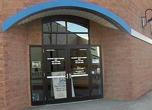
Delaware Sports Museum and Hall of Fame
Sports museum in Delaware, United States
Distance: Approx. 1259 meters
Latitude and longitude: 39.732,-75.5638
The Delaware Sports Museum and Hall of Fame was founded in 1976. Al Cartwright, who helped found it, was its first president and was inducted to its hall of fame in 1980. The current museum building was constructed in 1993.
Cleland Heights, Delaware
Unincorporated community in Delaware, United States
Distance: Approx. 459 meters
Latitude and longitude: 39.73472222,-75.57472222
Cleland Heights is an unincorporated community in New Castle County, Delaware, United States. It was established in 1952 and consists of about 450 houses.

St. Hedwig's Roman Catholic Church
Historic church in Delaware, United States
Distance: Approx. 1420 meters
Latitude and longitude: 39.74027778,-75.56611111
St. Hedwig's Roman Catholic Church is a historic Roman Catholic church located at Linden and S. Harrison Streets in Wilmington, New Castle County, Delaware. St.
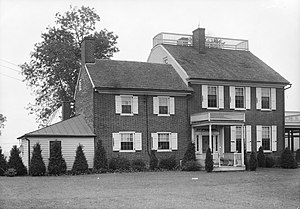
Woodstock (Wilmington, Delaware)
Historic house in Delaware, United States
Distance: Approx. 1483 meters
Latitude and longitude: 39.72182,-75.58997
Woodstock, also known as Banning Park, is a historic home located at Wilmington, New Castle County, Delaware. The house was restored in 1929. The "Woodstock" house stands at the highest point of the park.

Public School No. 19
United States historic place
Distance: Approx. 1054 meters
Latitude and longitude: 39.73744,-75.568606
Public School No. 19, also known as St. Hedwig's High School, is a historic elementary school building located at Wilmington, New Castle County, Delaware.

Glynrich
Historic house in Delaware, United States
Distance: Approx. 327 meters
Latitude and longitude: 39.7321,-75.5823
Glynrich is the site for two historic homes: the Richard Richardson House and the Brick Mill House. They are located at Wilmington, New Castle County, Delaware. The Brick Mill House, also known as the John Richardson House, was built about 1723, and is a two-story, three-bay, gable roof brick structure with Flemish bond and glazed headers on the facade rising from a full raised basement.

Union Park Gardens, Wilmington, Delaware
Historic site in Wilmington, Delaware
Distance: Approx. 1470 meters
Latitude and longitude: 39.745,-75.578
Union Park Gardens is a neighborhood located between Union Street and Lancaster Avenue in Wilmington, Delaware, United States. It was designed by landscape architect John Nolen and the architect Emile G. Perrot of the firm Ballinger & Perrot during the First World War. Union Park Gardens first served as housing for shipyard workers of the United States Shipping Board's Emergency Fleet Corporation.
Chase Center on the Riverfront
Convention center in Wilmington, Delaware
Distance: Approx. 1324 meters
Latitude and longitude: 39.731148,-75.56306
Chase Center on the Riverfront is a 92,000 square foot convention center in Wilmington, Delaware, United States. It hosts various local concerts, conventions, and banquets for the Wilmington area.
Weather in this IP's area
broken clouds
20 Celsius
20 Celsius
19 Celsius
21 Celsius
1015 hPa
82 %
1015 hPa
1012 hPa
10000 meters
2.57 m/s
30 degree
75 %
06:46:38
19:06:04