Country:
Region:
City:
Latitude and Longitude:
Time Zone:
Postal Code:
IP information under different IP Channel
ip-api
Country
Region
City
ASN
Time Zone
ISP
Blacklist
Proxy
Latitude
Longitude
Postal
Route
IPinfo
Country
Region
City
ASN
Time Zone
ISP
Blacklist
Proxy
Latitude
Longitude
Postal
Route
MaxMind
Country
Region
City
ASN
Time Zone
ISP
Blacklist
Proxy
Latitude
Longitude
Postal
Route
Luminati
Country
ASN
Time Zone
America/Chicago
ISP
Viewqwest Pte Ltd
Latitude
Longitude
Postal
db-ip
Country
Region
City
ASN
Time Zone
ISP
Blacklist
Proxy
Latitude
Longitude
Postal
Route
ipdata
Country
Region
City
ASN
Time Zone
ISP
Blacklist
Proxy
Latitude
Longitude
Postal
Route
Popular places and events near this IP address

Stanford Stadium
College stadium in California, USA
Distance: Approx. 489 meters
Latitude and longitude: 37.43444444,-122.16111111
Stanford Stadium is an outdoor college football stadium on the west coast of the United States, located on the campus of Stanford University in Stanford, California. It is the home of the Stanford Cardinal and hosts the university's commencement exercises. Opened 103 years ago in 1921 as a football and track and field stadium, it was an earthen horseshoe with wooden bleacher seating and flooring upon a steel frame.
Palo Alto High School
Comprehensive high school in Palo Alto, Santa Clara, California, United States
Distance: Approx. 243 meters
Latitude and longitude: 37.437,-122.157
Palo Alto Senior High School, commonly referred to locally as "Paly", is a comprehensive public high school in Palo Alto, California. Operated by the Palo Alto Unified School District, the school is one of two high schools in the district, the other being across town: Gunn High School, with which Paly has a rivalry. Palo Alto High School was originally established as a private school in 1894.

Castilleja School
Private, college-prep school in Palo Alto, California, United States
Distance: Approx. 646 meters
Latitude and longitude: 37.4388,-122.1517
Castilleja School is an independent school for girls in grades six through twelve, located in Palo Alto, California. Castilleja is the only non-sectarian all-girls middle and high school in the San Francisco Bay Area. The faculty consists of approximately 70 full-time and part-time women and men.

HP Garage
United States historic place
Distance: Approx. 629 meters
Latitude and longitude: 37.44307,-122.15481
The HP Garage is a private museum where the company Hewlett-Packard (HP) was founded. It is located at 367 Addison Avenue in Palo Alto, California. It is considered to be the "Birthplace of Silicon Valley".
Professorville
Historic district in Palo Alto, California, United States
Distance: Approx. 552 meters
Latitude and longitude: 37.4416057,-122.1541309
Professorville is a registered historic district in Palo Alto, California containing homes that were built by Stanford University professors. The historic district is bounded by Addison Avenue, Waverley Street, Kingsley Avenue, and Ramona Street. The community considers the district to be larger and bounded by Addison Avenue on the northwest, Cowper Street on the northeast, Embarcadero Road on the southeast, and Emerson Street on the southwest.
Stanford station
Train station in Palo Alto, California, U.S.
Distance: Approx. 207 meters
Latitude and longitude: 37.43861111,-122.15666667
Stanford station is a Caltrain station in Palo Alto, California, near the stadium on the Stanford University campus. It is not a regular service stop; instead, it is only in service for Stanford football home games and other large events at the stadium. The usual stop for the university is the Palo Alto station.

Bike Arc
Distance: Approx. 661 meters
Latitude and longitude: 37.4433,-122.1634
Bike Arc LLC, located in downtown Palo Alto, California, is a Silicon Valley startup that designs secure bicycle parking racks and systems. It was founded by Joseph Bellomo and Jeff Selzer in 2008. Jeff Selzer sits on the board of directors of the Silicon Valley Bicycle Coalition and is the General Manager of Palo Alto Bicycles.

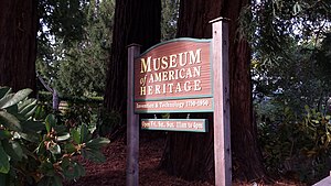
Museum of American Heritage
Palo Alto museum for 1750s-1950s electrical and mechanical technology and inventions
Distance: Approx. 670 meters
Latitude and longitude: 37.444411,-122.157543
The Museum of American Heritage (MOAH) is a museum in Palo Alto, California. It is dedicated to the preservation and display of electrical and mechanical technology and inventions from the 1750s through the 1950s. The museum has a large collection of artifacts that are generally not accessible to the public.
Maloney Field at Laird Q. Cagan Stadium
Distance: Approx. 607 meters
Latitude and longitude: 37.4331017,-122.1580511
Maloney Field at Laird Q. Cagan Stadium is a soccer-specific stadium on the campus of Stanford University in Stanford, California. The stadium hosts the Stanford Cardinal men's and women's soccer teams, as well as the women's lacrosse team. The facility opened in 1973, and featured renovations in 1997 and 2011.
Fraternal Hall Building
United States historic place
Distance: Approx. 609 meters
Latitude and longitude: 37.44333333,-122.16222222
The Fraternal Hall Building is a historic building in Palo Alto, California. It was built in 1898 for the Fraternal Hall Association. The founding members included Knights of Pythias and Freemasons.

Pacific Art League
Distance: Approx. 607 meters
Latitude and longitude: 37.44388889,-122.16005556
The Pacific Art League (PAL), formally known as the Palo Alto Art Club was founded in 1921 in Palo Alto, California and is a membership-run nonprofit arts organization, school, and gallery. The group is located in a historic building at 668 Ramona Street in downtown Palo Alto.
Palo Alto Medical Clinic
United States historic place
Distance: Approx. 590 meters
Latitude and longitude: 37.44361111,-122.15722222
Palo Alto Medical Clinic, also known as the Roth Building (structure built in 1932) was a former medical clinic. The building is located at 300 Homer street, at the corner of Bryant street in Palo Alto, California. It is listed on the National Register of Historic Places listings in Santa Clara County, California since 2010.
Weather in this IP's area
clear sky
26 Celsius
26 Celsius
21 Celsius
29 Celsius
1010 hPa
53 %
1010 hPa
1008 hPa
10000 meters
4.63 m/s
330 degree
07:09:44
18:42:32


