206.152.37.165 - IP Lookup: Free IP Address Lookup, Postal Code Lookup, IP Location Lookup, IP ASN, Public IP
Country:
Region:
City:
Location:
Time Zone:
Postal Code:
ISP:
ASN:
language:
User-Agent:
Proxy IP:
Blacklist:
IP information under different IP Channel
ip-api
Country
Region
City
ASN
Time Zone
ISP
Blacklist
Proxy
Latitude
Longitude
Postal
Route
db-ip
Country
Region
City
ASN
Time Zone
ISP
Blacklist
Proxy
Latitude
Longitude
Postal
Route
IPinfo
Country
Region
City
ASN
Time Zone
ISP
Blacklist
Proxy
Latitude
Longitude
Postal
Route
IP2Location
206.152.37.165Country
Region
missouri
City
town and country
Time Zone
America/Chicago
ISP
Language
User-Agent
Latitude
Longitude
Postal
ipdata
Country
Region
City
ASN
Time Zone
ISP
Blacklist
Proxy
Latitude
Longitude
Postal
Route
Popular places and events near this IP address

Chesterfield, Missouri
City in Missouri, United States
Distance: Approx. 3372 meters
Latitude and longitude: 38.65888889,-90.58027778
Chesterfield is a city in St. Louis County, Missouri, United States. It is a western suburb of St.

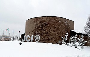
Junior Chamber International
Organization
Distance: Approx. 1417 meters
Latitude and longitude: 38.6555556,-90.5566667
Junior Chamber International, commonly referred to as JCI, is a non-profit international non-governmental organization of young people between 18 and 40 years old. It has members in about 127 countries, and regional or national organizations in most of them. The first local Junior Chamber chapter was founded in 1915, but the international umbrella organization Junior Chamber International (JCI) was founded in Mexico in 1944.
Parkway West High School (Missouri)
Public comprehensive high school in Ballwin, Missouri, United States
Distance: Approx. 2830 meters
Latitude and longitude: 38.62277778,-90.53472222
Parkway West High School is a public comprehensive high school in Chesterfield, Missouri, US, that is part of the Parkway School District.

Logan University
Chiropractice college in Chesterfield, Missouri, US
Distance: Approx. 1732 meters
Latitude and longitude: 38.6316,-90.5418
Logan University is a private university focused on chiropractic and the health sciences and located in Chesterfield, Missouri, United States.
United Hebrew Congregation (Chesterfield, Missouri)
Reform synagogue in St. Louis, Missouri, United States
Distance: Approx. 3041 meters
Latitude and longitude: 38.64779,-90.50964
The United Hebrew Congregation (also Congregation Achdut Yisroel) is a Reform Jewish synagogue located at 13788 Conway Road in Chesterfield, a western suburb of St. Louis, Missouri, in the United States. It was the first Jewish Congregation established west of the Mississippi River.
Burkhardt Historic District
Historic district in Missouri, United States
Distance: Approx. 3545 meters
Latitude and longitude: 38.66388889,-90.57916667
The Burkhardt Historic District, in Chesterfield, Missouri not far from the Missouri River, was listed on the National Register of Historic Places in 2000, and the listed area was expanded in 2006 to extend further down the south side of Chesterfield Airport Road. The district consists entirely or mostly of buildings built by or for businessman Edward Burkhardt along what was then known as Olive Street Road (sic) and later became Chesterfield Airport Road. It includes the [Farmers State Bank of Chesterfield (1914), a two-story commercial building which was individually listed on the National Register in 1999.

Chesterfield Mall
Shopping center in Chesterfield, Missouri, U.S.
Distance: Approx. 1937 meters
Latitude and longitude: 38.654,-90.565
Chesterfield Mall was a shopping mall in Chesterfield, Missouri, at the intersection of Interstate 64/U.S. Routes 40-61 and Clarkson Road (Route 340). The mall opened in 1976, built by Richard Jacobs. With the closing of Northwest Plaza in St.

Butterfly House, Missouri Botanical Garden
Butterfly zoo in Missouri
Distance: Approx. 1971 meters
Latitude and longitude: 38.66465,-90.54286
The Sophia M. Sachs Butterfly House is a butterfly zoo operated by the Missouri Botanical Gardens, and located in Faust Park in Chesterfield, Missouri, United States. The Butterfly House is accredited by the Association of Zoos and Aquariums (AZA).
Old Stone Church (Chesterfield, Missouri)
Historic church in Chesterfield, Missouri
Distance: Approx. 1811 meters
Latitude and longitude: 38.6496,-90.52404
The Old Stone Church in Chesterfield, Missouri, United States, is a historic church on Conway Road, across from Hoffman Road. It has also been known as Bonhomme Presbyterian Church and as Old Bonhomme Church. It was built in 1841 and added to the National Register of Historic Places in 1973.

Mercy Virtual
Hospital in Missouri, United States
Distance: Approx. 1300 meters
Latitude and longitude: 38.6504,-90.5589
Mercy Virtual is a virtual care center (also called a "virtual hospital") in Chesterfield, Missouri, a suburb of St. Louis, which operates solely through the use of telemedicine—the first facility of its kind in the world. Mercy Virtual provides remote services to patients in Mercy system hospitals and medical offices, and to other partner hospitals, by providing diagnosis, prognosis and treatment suggestions and remotely monitors individual patient health.
Lafayette Township, St. Louis County, Missouri
Township in St. Louis County, Missouri, U.S.
Distance: Approx. 3316 meters
Latitude and longitude: 38.61722222,-90.54361111
Lafayette Township is a township in St. Louis County, in the U.S. state of Missouri. Its population was 33,513 as of the 2010 census.

Faust Park
Park in Chesterfield, Missouri
Distance: Approx. 2570 meters
Latitude and longitude: 38.67,-90.542
Faust Park is a 200-acre public park in Chesterfield, Missouri.
Weather in this IP's area
clear sky
-5 Celsius
-11 Celsius
-6 Celsius
-4 Celsius
1030 hPa
58 %
1030 hPa
1008 hPa
10000 meters
4.63 m/s
290 degree

