Country:
 Australia
Region:
City:
Latitude and Longitude:
Time Zone:
Postal Code:
IP information under different IP Channel
ip-api
Country
Region
City
ASN
Time Zone
ISP
Blacklist
Proxy
Latitude
Longitude
Postal
Route
IPinfo
Country
Region
City
ASN
Time Zone
ISP
Blacklist
Proxy
Latitude
Longitude
Postal
Route
MaxMind
Country
Region
City
ASN
Time Zone
ISP
Blacklist
Proxy
Latitude
Longitude
Postal
Route
Luminati
Country
AURegion
vic
City
melbourne
ASN
Time Zone
Australia/Melbourne
ISP
Virtutel Pty Ltd
Latitude
Longitude
Postal
db-ip
Country
Region
City
ASN
Time Zone
ISP
Blacklist
Proxy
Latitude
Longitude
Postal
Route
ipdata
Country
Region
City
ASN
Time Zone
ISP
Blacklist
Proxy
Latitude
Longitude
Postal
Route
Popular places and events near this IP address

Surrey Hills, Victoria
Suburb of Melbourne, Victoria, Australia
Distance: Approx. 1422 meters
Latitude and longitude: -37.83,145.106
Surrey Hills is a suburb of Melbourne, Victoria, Australia, 11 km east of Melbourne's Central Business District, located within the Cities of Boroondara and Whitehorse local government areas. Surrey Hills recorded a population of 13,655 at the 2021 census. Surrey Hills was settled in the late 19th century and evolved with slightly smaller blocks and slightly simpler housing than its neighbour Canterbury.
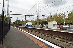
Surrey Hills railway station
Former railway station in Melbourne, Australia
Distance: Approx. 1821 meters
Latitude and longitude: -37.8239,145.099
Surrey Hills railway station was located on the Lilydale and Belgrave lines in Victoria, Australia, serving the eastern Melbourne suburb of Surrey Hills. Located between Chatham and Mont Albert, it opened on 13 August 1883 and closed on 17 February 2023, due to project works associated with the Level Crossing Removal Project.

Hartwell railway station
Railway station in Victoria, Australia
Distance: Approx. 1856 meters
Latitude and longitude: -37.8441,145.0756
Hartwell railway station is a commuter railway station on the Alamein line, serving the eastern Melbourne suburb of Camberwell in Victoria, Australia. Hartwell is a ground-level unstaffed station, featuring an island platform with two faces. It opened on 7 May 1906, with the current station provided in 1938.

Burwood railway station, Melbourne
Railway station in Melbourne, Australia
Distance: Approx. 1876 meters
Latitude and longitude: -37.8516,145.0805
Burwood railway station is a commuter railway station on the Alamein line, serving the eastern Melbourne suburb of Glen Iris in Victoria, Australia. Burwood is a ground-level unstaffed station, featuring two side platforms. It opened on 30 May 1890, with the current station provided in 1954.

Wattle Park, Melbourne
Park in Burwood, Melbourne, Victoria, Australia
Distance: Approx. 749 meters
Latitude and longitude: -37.839,145.1045
Wattle Park is a public park in Melbourne, Australia, located in the suburb of Burwood. It is known for its plantation of 12,000 wattle trees. It is currently maintained by Parks Victoria.
Presbyterian Ladies' College, Melbourne
School in Burwood, Victoria, Australia
Distance: Approx. 1244 meters
Latitude and longitude: -37.84777778,145.10638889
Presbyterian Ladies' College, Melbourne (PLC), is an independent, private, Presbyterian, day and boarding school for girls, located in Burwood, an eastern suburb of Melbourne, Victoria, Australia. Founded in 1875 at East Melbourne, PLC was one of the first independent schools for girls in Australia. The College has a non-selective enrolment policy and in 2007 catered for approximately 1,550 students from the Early Learning Centre (ELC) to Year 12, including 100 boarders.

South Surrey Park
Distance: Approx. 748 meters
Latitude and longitude: -37.8340106,145.092495
South Surrey Park is a park in Melbourne, Australia, located in the suburb of Surrey Hills. The park is progressively being replanted with indigenous native species. It is currently maintained by the City of Boroondara and the Friends of South Surrey Park.
Surrey Gardens
Distance: Approx. 1470 meters
Latitude and longitude: -37.826897,145.095862
Surrey Gardens is a park in Melbourne, Australia, located in the suburb of Surrey Hills. The park is situated high in Surrey Hills on sloping land from Union Road in the east to Norfolk Road in the west and contains many mature trees. It is maintained by the City of Boroondara.

Deakin Business School
Distance: Approx. 1386 meters
Latitude and longitude: -37.84555556,145.11027778
Deakin Graduate School of Business provides Deakin University's major postgraduate business programs covering Master of Business Administration, Master of Commerce, Master of International Business, Master of Marketing, and Doctor of Business Administration courses as well as Executive Development programs. A range of graduate certificate and diploma courses is offered as well. Approximately 3000 students are engaged in higher degrees by coursework or research, and other courses at the business school.
Strathcona Baptist Girls Grammar School
Baptist girl school in Melbourne, Australia
Distance: Approx. 1827 meters
Latitude and longitude: -37.82972222,145.08
Strathcona Girls Grammar School is an independent, Baptist, day school for girls, located in Canterbury, an inner-eastern suburb of Melbourne, Victoria, Australia. Established in 1924 by Florence Livingstone and Henrietta Hughes, the school currently caters for approximately 800 students from Preparatory to Year 12, over three campuses. Year nine girls attend 'Tay Creggan', a historic building on the Yarra River in Hawthorn.
Siena College (Camberwell)
Catholic, day school in Camberwell, Victoria, Australia
Distance: Approx. 1408 meters
Latitude and longitude: -37.8333,145.0826
Siena College is a Roman Catholic secondary school for girls in Camberwell, a suburb of Melbourne, Australia. It was founded by the Dominican Sisters in 1940. It is a member of Girls Sport Victoria and the Alliance of Girls' Schools Australasia.
Burwood Cemetery
Cemetery in Victoria, Australia
Distance: Approx. 1371 meters
Latitude and longitude: -37.85202,145.10004
Burwood Cemetery is a cemetery in Burwood, Victoria in Australia. It dates back to 1858, and was originally known as Nunawading General Cemetery. It is known as a resting place of notable figures from Melbourne.
Weather in this IP's area
overcast clouds
13 Celsius
13 Celsius
12 Celsius
14 Celsius
1016 hPa
77 %
1016 hPa
1008 hPa
10000 meters
0.89 m/s
4.92 m/s
310 degree
85 %
06:31:01
18:04:02