Country:
Region:
City:
Latitude and Longitude:
Time Zone:
Postal Code:
IP information under different IP Channel
ip-api
Country
Region
City
ASN
Time Zone
ISP
Blacklist
Proxy
Latitude
Longitude
Postal
Route
IPinfo
Country
Region
City
ASN
Time Zone
ISP
Blacklist
Proxy
Latitude
Longitude
Postal
Route
MaxMind
Country
Region
City
ASN
Time Zone
ISP
Blacklist
Proxy
Latitude
Longitude
Postal
Route
Luminati
Country
Region
vic
City
melbourne
ASN
Time Zone
Australia/Melbourne
ISP
Virtutel Pty Ltd
Latitude
Longitude
Postal
db-ip
Country
Region
City
ASN
Time Zone
ISP
Blacklist
Proxy
Latitude
Longitude
Postal
Route
ipdata
Country
Region
City
ASN
Time Zone
ISP
Blacklist
Proxy
Latitude
Longitude
Postal
Route
Popular places and events near this IP address

ABC Radio Melbourne
Radio station in Melbourne, Victoria
Distance: Approx. 928 meters
Latitude and longitude: -37.72055,144.784034
ABC Radio Melbourne (official callsign: 3LO) is an ABC Local Radio station in Melbourne, Australia. It began transmission on 13 October 1924 and was Melbourne's second licensed radio station after 3AR. ABC Local Radio stations in Victoria simulcast ABC Radio Melbourne's programming when not airing local shows for their areas.
Delahey, Victoria
Suburb of Melbourne, Victoria, Australia
Distance: Approx. 340 meters
Latitude and longitude: -37.719,144.777
Delahey is a suburb in Melbourne, Victoria, Australia, 20 km (12 mi) north-west of Melbourne's Central Business District, located within the City of Brimbank local government area. Delahey recorded a population of 8,077 at the 2021 census.

Sydenham, Victoria
Suburb of Melbourne, Victoria, Australia
Distance: Approx. 2116 meters
Latitude and longitude: -37.702,144.767
Sydenham is a suburb in Melbourne, Victoria, Australia, 22 km (14 mi) north-west of Melbourne's Central Business District, located within the City of Brimbank local government area. Sydenham recorded a population of 10,578 at the 2021 census.

Keilor Plains railway station
Railway station in Melbourne, Australia
Distance: Approx. 2054 meters
Latitude and longitude: -37.7294,144.7938
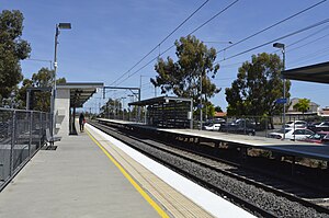
Keilor Plains railway station is a commuter railway station on the Sunbury line, which is part of the Melbourne railway network. It serves the western suburb of St Albans, in Melbourne, Victoria, Australia. Keilor Plains station is a ground level unstaffed station, featuring two side platforms.

Watergardens railway station
Railway station in Melbourne, Australia
Distance: Approx. 2171 meters
Latitude and longitude: -37.7008,144.7738
Watergardens railway station is a commuter railway station on the Sunbury line, which is part of the Melbourne railway network. It serves the western suburb of Sydenham, in Melbourne, Victoria, Australia. Watergardens station is a ground level premium station, featuring three platforms, an island platform with two faces and one side platform.
Taylors Lakes Secondary College
Secondary school in Taylors Lakes, Victoria, Australia
Distance: Approx. 2312 meters
Latitude and longitude: -37.70722222,144.79388889
Taylors Lakes Secondary College (TLSC) is a school situated in Melbourne's north western suburbs on Parmelia Drive, Taylors Lakes, Victoria, Australia.
Kings Park, Victoria
Suburb of Melbourne, Victoria, Australia
Distance: Approx. 1531 meters
Latitude and longitude: -37.734,144.772
Kings Park is a suburb in Melbourne, Victoria, Australia, 19 km (12 mi) north-west of Melbourne Central Business District, located within the City of Brimbank local government area. Kings Park recorded a population of 8,203 at the 2021 census. Kings Park was named after the King family, whose farm formed of the land the estate was developed on.

Taylors Hill, Victoria
Suburb of Melbourne, Victoria, Australia
Distance: Approx. 2067 meters
Latitude and longitude: -37.715,144.751
Taylors Hill is a suburb in Melbourne, Victoria, Australia, 22 km (14 mi) north-west of Melbourne's Central Business District, located within the City of Melton local government area. Taylors Hill recorded a population of 19,539 at the 2021 census. The boundaries are Gourlay Road to the west and Taylors Road to the south, while the eastern limit aligns with Overton Lea Boulevard and the northern limit aligns Chervil Close and Hume Drive.
Copperfield College
Distance: Approx. 199 meters
Latitude and longitude: -37.71888889,144.77211111
Copperfield College is a public school, located in the Western Suburbs of Melbourne, Victoria, Australia. It is a college comprising two junior campuses at year 7 to 10 and one senior campus at year 11 and 12. The junior campuses are located in Kings Park and Sydenham and the senior campus is located at Delahey.
Burnside Heights, Victoria
Suburb of Melbourne, Victoria, Australia
Distance: Approx. 1403 meters
Latitude and longitude: -37.727,144.76
Burnside Heights is a suburb in Melbourne, Victoria, Australia, 21 km (13 mi) north-west of Melbourne's Central Business District, located within the City of Melton local government area. Burnside Heights recorded a population of 6,377 at the 2021 census. Burnside Heights is separated from the suburb of Burnside to the south by Kororoit Creek and Caroline Springs.
Gilson College
School in Australia
Distance: Approx. 1015 meters
Latitude and longitude: -37.72416667,144.76305556
Gilson College is a Christian school, located in the Melbourne suburbs of Mernda and Taylors Hill, Victoria, Australia. It is a private co-educational early learning, primary, and secondary day school. The College caters to students from early learning through Year 12.

Macedonian Orthodox Cathedral of the Dormition of the Virgin Mary, Sydenham
Church in Victoria, Australia
Distance: Approx. 1768 meters
Latitude and longitude: -37.7045,144.77558
The Macedonian Orthodox Cathedral of the Dormition of the Virgin Mary (Macedonian: Македонска Православна Катедрална Црква „Успение на Пресвета Богородица“, Makedonska Pravoslavna Katedralna Crkva "Uspenie na Presveta Bogorodica) is a Macedonian Orthodox cathedral church located in Sydenham, a suburb of northwestern Melbourne, Victoria, Australia.
Weather in this IP's area
broken clouds
13 Celsius
12 Celsius
12 Celsius
14 Celsius
1016 hPa
74 %
1016 hPa
1005 hPa
10000 meters
6.17 m/s
280 degree
75 %
06:32:14
18:05:23