Country:
 Australia
Region:
City:
Latitude and Longitude:
Time Zone:
Postal Code:
IP information under different IP Channel
ip-api
Country
Region
City
ASN
Time Zone
ISP
Blacklist
Proxy
Latitude
Longitude
Postal
Route
IPinfo
Country
Region
City
ASN
Time Zone
ISP
Blacklist
Proxy
Latitude
Longitude
Postal
Route
MaxMind
Country
Region
City
ASN
Time Zone
ISP
Blacklist
Proxy
Latitude
Longitude
Postal
Route
Luminati
Country
AURegion
vic
City
melbourne
ASN
Time Zone
Australia/Melbourne
ISP
Virtutel Pty Ltd
Latitude
Longitude
Postal
db-ip
Country
Region
City
ASN
Time Zone
ISP
Blacklist
Proxy
Latitude
Longitude
Postal
Route
ipdata
Country
Region
City
ASN
Time Zone
ISP
Blacklist
Proxy
Latitude
Longitude
Postal
Route
Popular places and events near this IP address
Campbellfield, Victoria
Suburb of Melbourne, Victoria, Australia
Distance: Approx. 1543 meters
Latitude and longitude: -37.673,144.957
Campbellfield is a suburb in Melbourne, Victoria, Australia, 13 km (8.1 mi) north of Melbourne's Central Business District, located within the City of Hume local government area. Campbellfield recorded a population of 4,977 at the 2021 census.

Coolaroo, Victoria
Suburb of Melbourne, Victoria, Australia
Distance: Approx. 1799 meters
Latitude and longitude: -37.657,144.927
Coolaroo is a suburb in Melbourne, Victoria, Australia, 18 km (11 mi) north of Melbourne's Central Business District, located within the City of Hume local government area. Coolaroo recorded a population of 3,193 at the 2021 census.

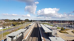
Upfield railway station
Railway station in Melbourne, Australia
Distance: Approx. 702 meters
Latitude and longitude: -37.666,144.9468
Upfield railway station is a commuter railway station and the terminus of the Upfield line, which is part of the Melbourne railway network. It serves the northern suburb of Campbellfield, in Melbourne, Victoria, Australia. Upfield station is a ground level premium station, featuring a single platform.

Dallas, Victoria
Suburb of Melbourne, Victoria, Australia
Distance: Approx. 156 meters
Latitude and longitude: -37.668,144.94
Dallas is a suburb in Melbourne, Victoria, Australia, 17 km (11 mi) north of the central business district, located within the City of Hume local government area. Dallas recorded a population of 6,762 at the 2021 census. Dallas is bounded by Barry Road in the north, the Upfield railway line in the east, Geach Street, Terang Street, Tempy Court, Dallas Drive and Riggall Street in the south, and the Craigieburn/North East railway line in the west.
Upfield, Victoria
Locality in Victoria, Melbourne, Australia
Distance: Approx. 683 meters
Latitude and longitude: -37.666259,144.946747
Upfield is a small residential and industrial locality 17 km away from the central business district in the northern suburbs of Melbourne, Victoria, Australia situated in the suburb of Campbellfield. It is in the local government area of the City of Hume. The name is descriptive of the area's open country.
Coolaroo railway station
Railway station in Coolaroo, Melbourne, Australia
Distance: Approx. 1624 meters
Latitude and longitude: -37.66,144.926
Coolaroo railway station is a commuter railway station on the North East line, which is part of the Melbourne railway network. It serves the northern suburb of Coolaroo, in Melbourne, Victoria, Australia. Coolaroo station is a ground level unstaffed station, featuring two side platforms.

Ilim College
Private school in Dallas, Victoria, Australia
Distance: Approx. 991 meters
Latitude and longitude: -37.66861111,144.92888889
Ilim College, formerly known as Islamic College North Western Region, was established in 1995 to provide Islamic education. Ilim College is a prep to year 12 VCE co-educational, private Islamic school. It is located in Dallas, Victoria, Australia.
Maygar Barracks
Distance: Approx. 1678 meters
Latitude and longitude: -37.68416667,144.94388889
Maygar Army Barracks is located in Broadmeadows, Victoria. It was the training area for the Australian Light Horse during World War I. The barracks was named after Victoria Cross winner Leslie Maygar, who received the award for his actions during the Second Boer War 1901 and later assisted in establishing the base in 1914. He was subsequently killed during the Battle of Beersheba in 1917.
The Meadows Greyhounds
Distance: Approx. 1744 meters
Latitude and longitude: -37.68194444,144.95194444
The Meadows Greyhounds is one of two metropolitan Greyhound racing tracks located in the Australian state of Victoria. The track is positioned within an industrial estate in the north western Melbourne suburb of Broadmeadows. The Meadows is one of 13 greyhound tracks located in Victoria; it has races on Saturday nights (Metropolitan meetings) and Wednesday days (Provincial meetings).
Melbourne Immigration Transit Accommodation
Australian immigration detention centre
Distance: Approx. 1813 meters
Latitude and longitude: -37.685,144.946
Melbourne Immigration Transit Accommodation (MITA) is an Australian immigration detention centre in the Melbourne suburb of Broadmeadows. It was built on part of the Maygar Barracks site. It is operated by Serco under contract to the Australian Border Force.
Broadmeadows Secondary College
School in Victoria, Australia
Distance: Approx. 1547 meters
Latitude and longitude: -37.67972222,144.92833333
Broadmeadows Secondary College was a co-educational secondary college located in Victoria, Australia. The college was located in Broadmeadows, a largely working class suburb of Melbourne. The college provided a comprehensive education from years 7 through to 12 offering both VCE and VCAL qualifications at Year 11 and 12 levels.

Scots Uniting Church, Campbellfield
Early Presbyterian church and graveyard in Victoria, Australia
Distance: Approx. 1636 meters
Latitude and longitude: -37.6758,144.9568
Scots Uniting Church, Campbellfield is a heritage-listed building at 1702 Hume Highway, Campbellfield, Victoria, Australia. It was added to the Victorian Heritage Register on 9 October 1974. It has one of the four remaining churchyards in Victoria.
Weather in this IP's area
broken clouds
13 Celsius
12 Celsius
12 Celsius
13 Celsius
1017 hPa
77 %
1017 hPa
1000 hPa
10000 meters
6.17 m/s
280 degree
75 %
06:31:32
18:04:45